Map of Zavala County - Zavala County is a county located in the U.S. state of Texas. Zavala County Map showing cities, highways, important places and water bodies. Get Where is Zavala County located in the map, major cities in Zavala county, population, areas, and places of interest.
Map of Zavala County, Texas
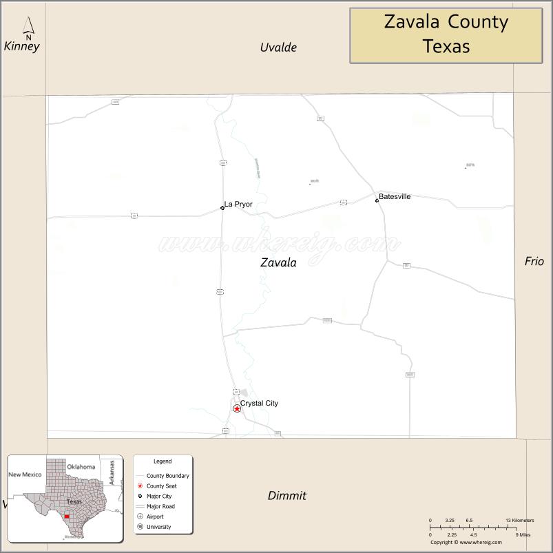
About Zavala County Map, Texas: The map showing the county boundary, county seat, major cities, highways, water bodies and neighbouring counties.
Related Texas Maps
Map of Zavala County, Texas
Zavala County is a county located in the U.S. state of Texas. It's county seat is Crystal City. As per 2020 census, the population of Zavala County is 9534 people and population density is square miles. According to the United States Census Bureau, the county has a total area of 1,299 sq mi (3,364 km2). Zavala County was established on 1846.
Facts about Zavala County, Texas
| Country | United States |
| State | Texas |
| Region | South Texas / Winter Garden Region |
| County Seat | Crystal City |
| Named After | Lorenzo de Zavala |
| Established | 1858 |
| Organized | 1884 |
| Coordinates | 28.8667° N, 99.7500° W |
| Total Area | 1,302 sq mi |
| Land Area | 1,297 sq mi |
| Water Area | 5 sq mi |
| Population (2020) | 9,670 |
| Population Rank | Sparsely populated South Texas county |
| Major City | Crystal City |
| Main Industries | Agriculture, Food Processing, Energy, Ranching |
| Major Airport | Crystal City Municipal Airport |
| Time Zone | Central Time (UTC−06:00) |
| Known For | Spinach Festival, WWII Internment Camp, Winter Garden agricultural region |
| Website | https://www.co.zavala.tx.us |
Top Attractions in Zavala County, Texas
- Fort Ewing (Historic Site) – Early frontier camp with local history significance.
- Escobar Park (Crystal City) – Community park with open space and recreation areas.
- Chacho’s Lake – Small lake popular for relaxing and outdoor activities.
- Zavala County Museum – Local exhibits on county heritage and early settlement.
- Downtown Crystal City – Historic district known for spinach-themed landmarks.
- Spinach Festival Grounds – Event area celebrating the county’s famous spinach history.
- La Pryor City Park – Neighborhood park with fields and picnic areas.
- Crystal City Golf Course – Small course offering recreational play.
- Nueces River Access Areas – Spots for fishing, wildlife viewing, and nature walks.
- Zavala County Courthouse – Historic courthouse with classic Texas architecture.
Cities and Towns in Zavala County, Texas
| Place | Type | Population (Census 2020) | Latitude & Longitude |
|---|---|---|---|
| Crystal City (county seat) | City | 6347 | 28.6775°N, 99.8281°W |
| La Pryor | Census Designated Place (CDP) | 1236 | 28.9456°N, 99.8453°W |
| Batesville | Census Designated Place (CDP) | 1090 | 28.9204°N, 99.6182°W |
| Chula Vista | Census Designated Place (CDP) | 625 | 28.6901°N, 99.7504°W |
| Loma Grande | Census Designated Place (CDP) | 165 | 28.7803°N, 99.8801°W |
| Amaya | Census Designated Place (CDP) | 51 | 28.8302°N, 99.9105°W |
| Cometa | Unincorporated Community | N/A | 28.7406°N, 99.7012°W |
| Las Colonias | Unincorporated Community | N/A | 28.7608°N, 99.7904°W |
| Palo Blanco | Unincorporated Community | N/A | 28.8011°N, 99.6509°W |
| New California | Unincorporated Community | N/A | 28.8703°N, 99.8702°W |
What are Major Roads and Highways in Zavala County
Major highways connect Zavala County with South Texas border regions and inland Texas cities.
- U.S. Highway 83 - primary north-south route connecting Crystal City with Uvalde, Laredo, and the Rio Grande Valley
- U.S. Highway 57 - connects the county with Eagle Pass and Interstate 35 corridor toward San Antonio
- State Highway 83 (Business routes and loops) - serves local access within Crystal City and nearby communities
- Farm to Market Road 117 - connects La Pryor with Crystal City and rural agricultural areas
- Farm to Market Road 1436 - serves eastern ranching and farming regions of the county
What are Neighboring Counties of Zavala County
- Uvalde County (north)
- Frio County (east)
- Dimmit County (south)
- La Salle County (southeast)
- Maverick County (west)
Distance from Zavala County to Nearby Cities
The following distances are measured by road (driving).
- Crystal City to Uvalde (Uvalde County), Texas - 40 mi (64 km)
- Crystal City to Carrizo Springs (Dimmit County), Texas - 42 mi (68 km)
- Crystal City to Eagle Pass (Maverick County), Texas - 78 mi (126 km)
- Crystal City to Laredo (Webb County), Texas - 120 mi (193 km)
- Crystal City to San Antonio (Bexar County), Texas - 94 mi (151 km)
- Crystal City to Pearsall (Frio County), Texas - 55 mi (89 km)
- Crystal City to Cotulla (La Salle County), Texas - 58 mi (93 km)
- Crystal City to Del Rio (Val Verde County), Texas - 115 mi (185 km)
- Crystal City to Austin (Travis County), Texas - 175 mi (282 km)
- Crystal City to Corpus Christi (Nueces County), Texas - 180 mi (290 km)
- Crystal City to McAllen (Hidalgo County), Texas - 210 mi (338 km)
- Crystal City to Brownsville (Cameron County), Texas - 245 mi (394 km)
- Crystal City to Houston (Harris County), Texas - 300 mi (483 km)
- Crystal City to Dallas (Dallas County), Texas - 350 mi (563 km)
- Crystal City to El Paso (El Paso County), Texas - 410 mi (660 km)
Waterbodies in Zavala County
Leona River, Nueces River tributaries, Seco Creek, Turkey Creek, Elm Creek, Chacon Creek, Las Moras Creek tributaries, seasonal arroyos, South Texas brushland ponds, Edwards Plateau watershed edges
Best Golf Courses in Zavala County, Texas
| Golf Course | Location | Latitude & Longitude |
|---|---|---|
| Crystal City Golf Course | Crystal City | 28.6792°N, 99.8310°W |
| La Pryor Golf Area (local course) | La Pryor | 28.9431°N, 99.8472°W |
Colleges and Universities in Zavala County, Texas
| Institution Name | Type (Public/Private) | Level | Notable For |
|---|---|---|---|
| Southwest Texas Junior College | Public | Community College | Main higher education provider for Zavala County |
| University of Texas Rio Grande Valley | Public | University | Regional research university serving South Texas |
| Texas A&M International University | Public | University | Border-region academic and business programs |
| Texas A&M University-Kingsville | Public | University | Engineering and agriculture programs in South Texas |
| Our Lady of the Lake University - San Antonio | Private | University | Regional liberal arts and graduate programs |
References
- U.S. Census Bureau QuickFacts - Zavala County
- Texas State Historical Association - Zavala County
- Official Zavala County Website
- Southwest Texas Junior College
- Texas Rivers & Watersheds - National Park Service
- Anderson County Map
- Andrews County Map
- Angelina County Map
- Aransas County Map
- Archer County Map
- Armstrong County Map
- Atascosa County Map
- Austin County Map
- Bailey County Map
- Bandera County Map
- Bastrop County Map
- Baylor County Map
- Bee County Map
- Bell County Map
- Bexar County Map
- Blanco County Map
- Borden County Map
- Bosque County Map
- Bowie County Map
- Brazoria County Map
- Brazos County Map
- Brewster County Map
- Briscoe County Map
- Brooks County Map
- Brown County Map
- Burleson County Map
- Burnet County Map
- Caldwell County Map
- Calhoun County Map
- Callahan County Map
- Cameron County Map
- Camp County Map
- Carson County Map
- Cass County Map
- Castro County Map
- Chambers County Map
- Cherokee County Map
- Childress County Map
- Clay County Map
- Cochran County Map
- Coke County Map
- Coleman County Map
- Collin County Map
- Collingsworth County Map
- Colorado County Map
- Comal County Map
- Comanche County Map
- Concho County Map
- Cooke County Map
- Coryell County Map
- Cottle County Map
- Crane County Map
- Crockett County Map
- Crosby County Map
- Culberson County Map
- Dallam County Map
- Dallas County Map
- Dawson County Map
- Deaf Smith County Map
- Delta County Map
- Denton County Map
- DeWitt County Map
- Dickens County Map
- Dimmit County Map
- Donley County Map
- Duval County Map
- Eastland County Map
- Ector County Map
- Edwards County Map
- Ellis County Map
- El Paso County Map
- Erath County Map
- Falls County Map
- Fannin County Map
- Fayette County Map
- Fisher County Map
- Floyd County Map
- Foard County Map
- Fort Bend County Map
- Franklin County Map
- Freestone County Map
- Frio County Map
- Gaines County Map
- Galveston County Map
- Garza County Map
- Gillespie County Map
- Glasscock County Map
- Goliad County Map
- Gonzales County Map
- Gray County Map
- Grayson County Map
- Gregg County Map
- Grimes County Map
- Guadalupe County Map
- Hale County Map
- Hall County Map
- Hamilton County Map
- Hansford County Map
- Hardeman County Map
- Hardin County Map
- Harris County Map
- Harrison County Map
- Hartley County Map
- Haskell County Map
- Hays County Map
- Hemphill County Map
- Henderson County Map
- Hidalgo County Map
- Hill County Map
- Hockley County Map
- Hood County Map
- Hopkins County Map
- Houston County Map
- Howard County Map
- Hudspeth County Map
- Hunt County Map
- Hutchinson County Map
- Irion County Map
- Jack County Map
- Jackson County Map
- Jasper County Map
- Jeff Davis County Map
- Jefferson County Map
- Jim Hogg County Map
- Jim Wells County Map
- Johnson County Map
- Jones County Map
- Karnes County Map
- Kaufman County Map
- Kendall County Map
- Kenedy County Map
- Kent County Map
- Kerr County Map
- Kimble County Map
- King County Map
- Kinney County Map
- Kleberg County Map
- Knox County Map
- Lamar County Map
- Lamb County Map
- Lampasas County Map
- La Salle County Map
- Lavaca County Map
- Lee County Map
- Leon County Map
- Liberty County Map
- Limestone County Map
- Lipscomb County Map
- Live Oak County Map
- Llano County Map
- Loving County Map
- Lubbock County Map
- Lynn County Map
- McCulloch County Map
- McLennan County Map
- McMullen County Map
- Madison County Map
- Marion County Map
- Martin County Map
- Mason County Map
- Matagorda County Map
- Maverick County Map
- Medina County Map
- Menard County Map
- Midland County Map
- Milam County Map
- Mills County Map
- Mitchell County Map
- Montague County Map
- Montgomery County Map
- Moore County Map
- Morris County Map
- Motley County Map
- Nacogdoches County Map
- Navarro County Map
- Newton County Map
- Nolan County Map
- Nueces County Map
- Ochiltree County Map
- Oldham County Map
- Orange County Map
- Palo Pinto County Map
- Panola County Map
- Parker County Map
- Parmer County Map
- Pecos County Map
- Polk County Map
- Potter County Map
- Presidio County Map
- Rains County Map
- Randall County Map
- Reagan County Map
- Real County Map
- Red River County Map
- Reeves County Map
- Refugio County Map
- Roberts County Map
- Robertson County Map
- Rockwall County Map
- Runnels County Map
- Rusk County Map
- Sabine County Map
- San Augustine County Map
- San Jacinto County Map
- San Patricio County Map
- San Saba County Map
- Schleicher County Map
- Scurry County Map
- Shackelford County Map
- Shelby County Map
- Sherman County Map
- Smith County Map
- Somervell County Map
- Starr County Map
- Stephens County Map
- Sterling County Map
- Stonewall County Map
- Sutton County Map
- Swisher County Map
- Tarrant County Map
- Taylor County Map
- Terrell County Map
- Terry County Map
- Throckmorton County Map
- Titus County Map
- Tom Green County Map
- Travis County Map
- Trinity County Map
- Tyler County Map
- Upshur County Map
- Upton County Map
- Uvalde County Map
- Val Verde County Map
- Van Zandt County Map
- Victoria County Map
- Walker County Map
- Waller County Map
- Ward County Map
- Washington County Map
- Webb County Map
- Wharton County Map
- Wheeler County Map
- Wichita County Map
- Wilbarger County Map
- Willacy County Map
- Williamson County Map
- Wilson County Map
- Winkler County Map
- Wise County Map
- Wood County Map
- Yoakum County Map
- Young County Map
- Zapata County Map
- Zavala County Map
- Alabama Counties
- Alaska boroughs
- Arizona Counties
- Arkansas Counties
- California County Map
- Colorado Counties
- Connecticut Counties
- Delaware Counties
- Florida County Map
- Georgia County Map
- Hawaii Counties
- Idaho Counties
- Illinois Counties
- Indiana Counties
- Iowa Counties
- Kansas Counties
- Kentucky Counties
- Louisiana Counties
- Maine Counties
- Maryland Counties
- Massachusetts Counties
- Michigan County Map
- Minnesota Counties
- Mississippi Counties
- Missouri Counties
- Montana Counties
- Nebraska Counties
- Nevada Counties
- New York Counties
- New Hampshire Counties
- New Jersey Counties
- New Mexico Counties
- North Carolina Counties
- North Dakota Counties
- Ohio County Map
- Oklahoma Counties
- Oregon Counties
- Pennsylvania Counties
- Rhode Island Counties
- South Carolina Counties
- South Dakota Counties
- Map of Tennessee
- Texas County Map
- Utah Counties
- Vermont Counties
- Virginia Counties
- Washington Counties
- West Virginia Counties
- Wisconsin Counties
- Wyoming Counties
References
- ^ QuickFacts: Zavala County, Texas - United States Census Bureau
- ^ United States Census Bureau - Population and Housing Data
- ^ TIGER/Line Shapefiles - United States Census Bureau
- ^ United States Geological Survey (USGS)
- ^ National Geodetic Survey (NGS), NOAA
- ^ Official Website of Zavala County, Texas
- ^ Texas Department of Transportation (TxDOT)