Map of Presidio County - Presidio County is a county located in the U.S. state of Texas. Presidio County Map showing cities, highways, important places and water bodies. Get Where is Presidio County located in the map, major cities in Presidio county, population, areas, and places of interest.
Map of Presidio County, Texas
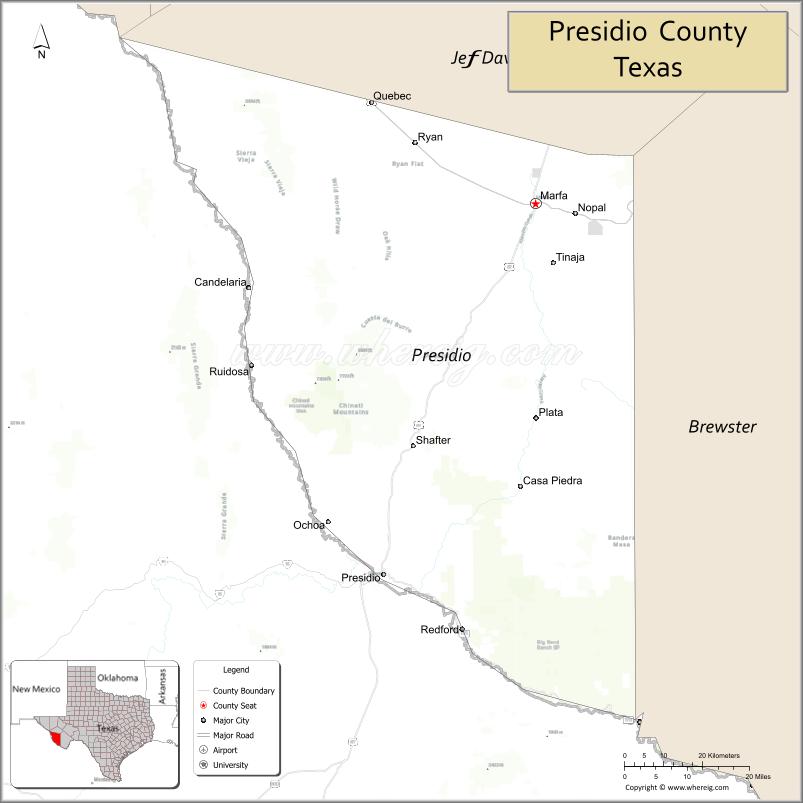
About Presidio County Map, Texas: The map showing the county boundary, county seat, major cities, highways, water bodies and neighbouring counties.
Related Texas Maps
Map of Presidio County, Texas
Presidio County is a county located in the U.S. state of Texas. It's county seat is Marfa. As per 2020 census, the population of Presidio County is 6140 people and population density is square miles. According to the United States Census Bureau, the county has a total area of 3,856 sq mi (9,987 km2). Presidio County was established on 1850.
Facts about Presidio County, Texas
| Country | United States |
| State | Texas |
| Region | Trans-Pecos / West Texas / Big Bend Region |
| County Seat | Marfa |
| Named After | Presidio del Norte, an 18th-century Spanish fort |
| Established | 1850 |
| Organized | 1875 |
| Coordinates | 29.9990° N, 104.2050° W |
| Total Area | 3,856 sq mi |
| Land Area | 3,855 sq mi |
| Water Area | <1 sq mi |
| Population (2020) | 6,131 |
| Population Rank | Sparsely populated county in the Big Bend region |
| Major City | Marfa |
| Main Industries | Tourism, Ranching, Border Trade, Arts & Culture |
| Major Airport | Marfa Municipal Airport (local) |
| Time Zone | Central Time (UTC−06:00) |
| Known For | Marfa Lights, Chinati Foundation, High desert landscapes |
| Website | https://www.co.presidio.tx.us |
Top Attractions in Presidio County, Texas
- Marfa Lights Viewing Area – Famous unexplained night lights.
- Chinati Foundation – Large-scale contemporary art installations.
- Prada Marfa – Iconic desert art installation.
- Fort D.A. Russell – Historic military site and art spaces.
- Downtown Marfa – Galleries, shops, and cafés.
- Presidio County Courthouse – Historic courthouse with panoramic views.
- Big Bend Ranch State Park (access from Presidio) – Rugged trails and desert scenery.
- Rio Grande Scenic Drive (FM 170) – Stunning river and canyon views.
- Shafter Ghost Town – Old mining town ruins and cemetery.
- Marfa Mystery Lights Center – Exhibits about the phenomenon.
Cities and Towns in Presidio County, Texas
| Place | Type | Population (Census 2020) | Latitude & Longitude |
|---|---|---|---|
| Marfa (county seat) | City | 1788 | 30.3091°N, 104.0206°W |
| Presidio | City | 3264 | 29.5607°N, 104.3721°W |
| Redford | Census Designated Place (CDP) | 90 | 29.4469°N, 104.1702°W |
| Candelaria | Unincorporated Community | N/A | 30.1408°N, 104.6825°W |
| Ruidosa | Unincorporated Community | N/A | 30.2964°N, 104.6394°W |
| Shafter | Ghost Town / Historic Community | N/A | 29.8208°N, 104.3031°W |
| Chinati | Unincorporated Community | N/A | 29.9361°N, 104.4797°W |
| Plata | Unincorporated Community | N/A | 30.0738°N, 104.5036°W |
| Valentine (partly in Jeff Davis County) | Community | 187 | 30.5880°N, 104.4966°W |
| Casa Piedra | Historic Community | N/A | 29.8008°N, 104.5855°W |
What are Major Roads and Highways in Presidio County
- U.S. Highway 67 - major north-south route connecting Presidio, Marfa, and Alpine
- U.S. Highway 90 - principal east-west corridor through Marfa and Valentine
- Texas State Highway 17 - connects Marfa with Fort Davis and Alpine
- Farm to Market Road 170 - scenic River Road following the Rio Grande between Presidio and Big Bend Ranch State Park
- Farm to Market Road 2810 - serves rural ranching areas and border communities
- Ranch Road network connecting remote desert and mountain regions
- International Bridge at Presidio-Ojinaga providing access to Chihuahua, Mexico
What are Neighboring Counties of Presidio County
- Jeff Davis County (north)
- Brewster County (east)
- State of Chihuahua, Mexico (south and west across the Rio Grande)
Distance from Presidio County to Nearby Cities
| City | Distance (km) | Distance (mi) |
|---|---|---|
| Presidio | 93 | 58 |
| Redford | 124 | 77 |
| Valentine | 48 | 30 |
| Alpine (Brewster County) | 42 | 26 |
| Fort Davis (Jeff Davis County) | 34 | 21 |
| Terlingua (Brewster County) | 149 | 93 |
| Van Horn (Culberson County) | 119 | 74 |
| Fort Stockton (Pecos County) | 246 | 153 |
| Odessa (Ector County) | 327 | 203 |
| Midland (Midland County) | 347 | 216 |
| El Paso (El Paso County) | 307 | 191 |
| Del Rio (Val Verde County) | 417 | 259 |
| San Angelo (Tom Green County) | 437 | 272 |
| Austin (Travis County) | 676 | 420 |
| Dallas (Dallas County) | 878 | 546 |
Waterbodies in Presidio County
Rio Grande, Alamito Creek, Cibolo Creek, Capote Creek, Pinto Canyon drainage, Chinati Creek, Fresno Creek tributaries, mountain springs, desert arroyos, stock tanks, reservoirs, wetlands along the Rio Grande floodplain, and seasonal waterways throughout the Chihuahuan Desert
Best Golf Courses in Presidio County, Texas
| Golf Course | Location | Latitude & Longitude |
|---|---|---|
| Black Jack's Crossing Golf Course | Lajitas | 29.2603°N, 103.7732°W |
| Alpine Country Club | Alpine | 30.3524°N, 103.6702°W |
| Fort Davis Country Club | Fort Davis | 30.5884°N, 103.9014°W |
| Nueva Vista Golf Club | Midland | 31.9687°N, 102.1036°W |
Colleges and Universities in Presidio County, Texas
| Institution Name | Type | Level | Notable For |
|---|---|---|---|
| Odessa College - Presidio Center | Public | Community College | Provides higher education and workforce training opportunities for county residents |
| Sul Ross State University | Public | University | Regional university serving the Big Bend and Trans-Pecos regions |
| Midland College | Public | Community College | Higher education opportunities for West Texas students |
| Texas A&M AgriLife Extension Service - Presidio County | Public | University | Ranching, agriculture, natural resources, and community education programs |
References
- Official Presidio County Website
- U.S. Census Bureau - Presidio County QuickFacts
- Texas State Historical Association - Presidio County
- Texas Almanac - Presidio County
- Sul Ross State University
- Anderson County Map
- Andrews County Map
- Angelina County Map
- Aransas County Map
- Archer County Map
- Armstrong County Map
- Atascosa County Map
- Austin County Map
- Bailey County Map
- Bandera County Map
- Bastrop County Map
- Baylor County Map
- Bee County Map
- Bell County Map
- Bexar County Map
- Blanco County Map
- Borden County Map
- Bosque County Map
- Bowie County Map
- Brazoria County Map
- Brazos County Map
- Brewster County Map
- Briscoe County Map
- Brooks County Map
- Brown County Map
- Burleson County Map
- Burnet County Map
- Caldwell County Map
- Calhoun County Map
- Callahan County Map
- Cameron County Map
- Camp County Map
- Carson County Map
- Cass County Map
- Castro County Map
- Chambers County Map
- Cherokee County Map
- Childress County Map
- Clay County Map
- Cochran County Map
- Coke County Map
- Coleman County Map
- Collin County Map
- Collingsworth County Map
- Colorado County Map
- Comal County Map
- Comanche County Map
- Concho County Map
- Cooke County Map
- Coryell County Map
- Cottle County Map
- Crane County Map
- Crockett County Map
- Crosby County Map
- Culberson County Map
- Dallam County Map
- Dallas County Map
- Dawson County Map
- Deaf Smith County Map
- Delta County Map
- Denton County Map
- DeWitt County Map
- Dickens County Map
- Dimmit County Map
- Donley County Map
- Duval County Map
- Eastland County Map
- Ector County Map
- Edwards County Map
- Ellis County Map
- El Paso County Map
- Erath County Map
- Falls County Map
- Fannin County Map
- Fayette County Map
- Fisher County Map
- Floyd County Map
- Foard County Map
- Fort Bend County Map
- Franklin County Map
- Freestone County Map
- Frio County Map
- Gaines County Map
- Galveston County Map
- Garza County Map
- Gillespie County Map
- Glasscock County Map
- Goliad County Map
- Gonzales County Map
- Gray County Map
- Grayson County Map
- Gregg County Map
- Grimes County Map
- Guadalupe County Map
- Hale County Map
- Hall County Map
- Hamilton County Map
- Hansford County Map
- Hardeman County Map
- Hardin County Map
- Harris County Map
- Harrison County Map
- Hartley County Map
- Haskell County Map
- Hays County Map
- Hemphill County Map
- Henderson County Map
- Hidalgo County Map
- Hill County Map
- Hockley County Map
- Hood County Map
- Hopkins County Map
- Houston County Map
- Howard County Map
- Hudspeth County Map
- Hunt County Map
- Hutchinson County Map
- Irion County Map
- Jack County Map
- Jackson County Map
- Jasper County Map
- Jeff Davis County Map
- Jefferson County Map
- Jim Hogg County Map
- Jim Wells County Map
- Johnson County Map
- Jones County Map
- Karnes County Map
- Kaufman County Map
- Kendall County Map
- Kenedy County Map
- Kent County Map
- Kerr County Map
- Kimble County Map
- King County Map
- Kinney County Map
- Kleberg County Map
- Knox County Map
- Lamar County Map
- Lamb County Map
- Lampasas County Map
- La Salle County Map
- Lavaca County Map
- Lee County Map
- Leon County Map
- Liberty County Map
- Limestone County Map
- Lipscomb County Map
- Live Oak County Map
- Llano County Map
- Loving County Map
- Lubbock County Map
- Lynn County Map
- McCulloch County Map
- McLennan County Map
- McMullen County Map
- Madison County Map
- Marion County Map
- Martin County Map
- Mason County Map
- Matagorda County Map
- Maverick County Map
- Medina County Map
- Menard County Map
- Midland County Map
- Milam County Map
- Mills County Map
- Mitchell County Map
- Montague County Map
- Montgomery County Map
- Moore County Map
- Morris County Map
- Motley County Map
- Nacogdoches County Map
- Navarro County Map
- Newton County Map
- Nolan County Map
- Nueces County Map
- Ochiltree County Map
- Oldham County Map
- Orange County Map
- Palo Pinto County Map
- Panola County Map
- Parker County Map
- Parmer County Map
- Pecos County Map
- Polk County Map
- Potter County Map
- Presidio County Map
- Rains County Map
- Randall County Map
- Reagan County Map
- Real County Map
- Red River County Map
- Reeves County Map
- Refugio County Map
- Roberts County Map
- Robertson County Map
- Rockwall County Map
- Runnels County Map
- Rusk County Map
- Sabine County Map
- San Augustine County Map
- San Jacinto County Map
- San Patricio County Map
- San Saba County Map
- Schleicher County Map
- Scurry County Map
- Shackelford County Map
- Shelby County Map
- Sherman County Map
- Smith County Map
- Somervell County Map
- Starr County Map
- Stephens County Map
- Sterling County Map
- Stonewall County Map
- Sutton County Map
- Swisher County Map
- Tarrant County Map
- Taylor County Map
- Terrell County Map
- Terry County Map
- Throckmorton County Map
- Titus County Map
- Tom Green County Map
- Travis County Map
- Trinity County Map
- Tyler County Map
- Upshur County Map
- Upton County Map
- Uvalde County Map
- Val Verde County Map
- Van Zandt County Map
- Victoria County Map
- Walker County Map
- Waller County Map
- Ward County Map
- Washington County Map
- Webb County Map
- Wharton County Map
- Wheeler County Map
- Wichita County Map
- Wilbarger County Map
- Willacy County Map
- Williamson County Map
- Wilson County Map
- Winkler County Map
- Wise County Map
- Wood County Map
- Yoakum County Map
- Young County Map
- Zapata County Map
- Zavala County Map
- Alabama Counties
- Alaska boroughs
- Arizona Counties
- Arkansas Counties
- California County Map
- Colorado Counties
- Connecticut Counties
- Delaware Counties
- Florida County Map
- Georgia County Map
- Hawaii Counties
- Idaho Counties
- Illinois Counties
- Indiana Counties
- Iowa Counties
- Kansas Counties
- Kentucky Counties
- Louisiana Counties
- Maine Counties
- Maryland Counties
- Massachusetts Counties
- Michigan County Map
- Minnesota Counties
- Mississippi Counties
- Missouri Counties
- Montana Counties
- Nebraska Counties
- Nevada Counties
- New York Counties
- New Hampshire Counties
- New Jersey Counties
- New Mexico Counties
- North Carolina Counties
- North Dakota Counties
- Ohio County Map
- Oklahoma Counties
- Oregon Counties
- Pennsylvania Counties
- Rhode Island Counties
- South Carolina Counties
- South Dakota Counties
- Map of Tennessee
- Texas County Map
- Utah Counties
- Vermont Counties
- Virginia Counties
- Washington Counties
- West Virginia Counties
- Wisconsin Counties
- Wyoming Counties
References
- ^ QuickFacts: Presidio County, Texas - United States Census Bureau
- ^ United States Census Bureau - Population and Housing Data
- ^ TIGER/Line Shapefiles - United States Census Bureau
- ^ United States Geological Survey (USGS)
- ^ National Geodetic Survey (NGS), NOAA
- ^ Official Website of Presidio County, Texas
- ^ Texas Department of Transportation (TxDOT)