Map of Denton County - Denton County is a county located in the U.S. state of Texas. Denton County Map showing cities, highways, important places and water bodies. Get Where is Denton County located in the map, major cities in Denton county, population, areas, and places of interest.
Map of Denton County, Texas
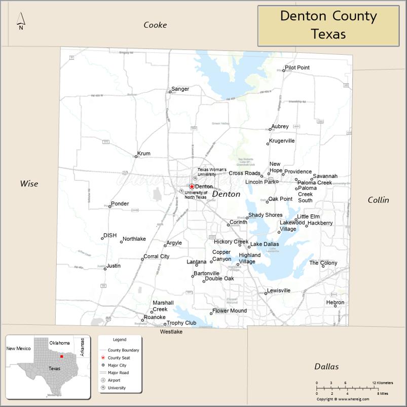
About Denton County Map, Texas: The map showing the county boundary, county seat, major cities, highways, water bodies and neighbouring counties.
Related Texas Maps
Map of Denton County, Texas
Denton County is a county located in the U.S. state of Texas. It's county seat is Denton. As per 2020 census, the population of Denton County is 941647 people and population density is square miles. According to the United States Census Bureau, the county has a total area of 888 sq mi (2,300 km2). Denton County was established on 1846.
Facts about Denton County, Texas
| Country | United States |
| State | Texas |
| Region | North Texas / Dallas–Fort Worth Metroplex |
| County Seat | Denton |
| Named After | John B. Denton |
| Established | 1846 |
| Organized | 1846 |
| Coordinates | 33.2148° N, 97.1331° W |
| Total Area | 953 sq mi |
| Land Area | 878 sq mi |
| Water Area | 75 sq mi |
| Population (2020) | 906,422 |
| Population Rank | One of the fastest-growing counties in both Texas and the U.S. |
| Major Cities | Denton, Lewisville, Flower Mound, Carrollton (part), The Colony |
| Main Industries | Education, Technology, Healthcare, Retail, Manufacturing |
| Major Airport | Denton Enterprise Airport; DFW International Airport nearby |
| Time Zone | Central Time (UTC−06:00) |
| Known For | University of North Texas, Texas Woman’s University, Music & arts scene, Lewisville Lake |
| Website | https://www.dentoncounty.gov |
Top Attractions in Denton County, Texas
- Downtown Denton Square – Lively shops, cafés, live music, and a historic courthouse.
- Denton County Courthouse-on-the-Square Museum – Exhibits on regional history and culture.
- Lewisville Lake – Boating, fishing, swimming, and lakeside parks.
- Ray Roberts Lake State Park – Isle du Bois & Johnson Branch – Trails, camping, and nature viewing.
- Little Chapel in the Woods – Beautiful historic chapel at TWU.
- University of North Texas Campus – Arts, music, and cultural attractions.
- Denton Community Market – Farmers market with local vendors and live entertainment.
- Arbor Hills Nature Preserve (Nearby in Plano) – Popular trails and scenic overlooks.
- Zone Action Park – Go-karting, mini-golf, and family fun.
- Old Alton Bridge (“Goatman’s Bridge”) – Historic iron bridge with folklore and hiking trails.
Cities and Towns in Denton County, Texas
| Place | Type | Population (Census 2020) | Latitude & Longitude |
|---|---|---|---|
| Denton (county seat) | City | 139869 | 33.2148°N, 97.1331°W |
| Lewisville | City | 111822 | 33.0462°N, 96.9942°W |
| Flower Mound | Town | 75650 | 33.0146°N, 97.0969°W |
| The Colony | City | 44275 | 33.0890°N, 96.8864°W |
| Little Elm | City | 51442 | 33.1626°N, 96.9375°W |
| Frisco (partly in Collin County) | City | 200509 | 33.1507°N, 96.8236°W |
| Carrollton (partly in Dallas and Collin counties) | City | 133434 | 32.9756°N, 96.8899°W |
| Corinth | City | 22316 | 33.1548°N, 97.0647°W |
| Highland Village | City | 15900 | 33.0918°N, 97.0619°W |
| Lake Dallas | City | 7851 | 33.1196°N, 97.0258°W |
| Sanger | City | 6916 | 33.3637°N, 97.1739°W |
| Krum | City | 5157 | 33.2612°N, 97.2389°W |
| Aubrey | City | 5595 | 33.3043°N, 96.9864°W |
| Pilot Point | City | 4381 | 33.3965°N, 96.9603°W |
| Justin | City | 3942 | 33.0848°N, 97.2969°W |
| Roanoke | City | 9430 | 33.0046°N, 97.2258°W |
| Argyle | Town | 4106 | 33.1229°N, 97.1831°W |
| Cross Roads | Town | 1744 | 33.2312°N, 97.0019°W |
| Double Oak | Town | 3054 | 33.0651°N, 97.1100°W |
| Trophy Club (partly in Tarrant County) | Town | 13688 | 32.9979°N, 97.1836°W |
| Copper Canyon | Town | 1334 | 33.0954°N, 97.0964°W |
| Corral City | Town | 33 | 33.1048°N, 97.1705°W |
| Hackberry | Town | 968 | 33.1527°N, 96.9178°W |
| Shady Shores | Town | 2518 | 33.1646°N, 96.9584°W |
| Providence Village | Town | 6847 | 33.2367°N, 96.9678°W |
| Oak Point | City | 4786 | 33.1909°N, 96.9914°W |
| Northlake | Town | 1724 | 33.0882°N, 97.2545°W |
| Bartonville | Town | 1726 | 33.0782°N, 97.1317°W |
| Krugerville | City | 1766 | 33.2815°N, 96.9895°W |
What are Major Roads and Highways in Denton County
Major highways connect the county to nearby regions and cities.
- Interstate 35E - north-south route through Denton, Lewisville, and Carrollton
- Interstate 35W - connects Denton with Fort Worth
- U.S. Highway 377 - serves Denton, Pilot Point, Krugerville, and Argyle
- U.S. Highway 380 - east-west route linking Denton, Frisco, and McKinney
- State Highway 121 - major corridor through The Colony, Lewisville, and Carrollton
- Interstate 635 - connects southern Denton County with Dallas County
- President George Bush Turnpike - serves southeastern Denton County suburbs
- State Highway 114 - links Roanoke, Trophy Club, and the DFW Airport area
- Loop 288 - bypass around the city of Denton
What are Neighboring Counties of Denton County
- Cooke County (north)
- Grayson County (northeast)
- Collin County (east)
- Dallas County (southeast)
- Tarrant County (southwest)
- Wise County (west)
Distance from Denton County to Nearby Cities
The following distances are measured by road (driving).
- Denton to Lewisville (Denton County), Texas - 18 mi (29 km)
- Denton to Flower Mound (Denton County), Texas - 15 mi (24 km)
- Denton to Little Elm (Denton County), Texas - 18 mi (29 km)
- Denton to Frisco (Denton County), Texas - 23 mi (37 km)
- Denton to Sanger (Denton County), Texas - 10 mi (16 km)
- Denton to Krum (Denton County), Texas - 8 mi (13 km)
- Denton to Pilot Point (Denton County), Texas - 20 mi (32 km)
- Denton to McKinney (Collin County), Texas - 31 mi (50 km)
- Denton to Gainesville (Cooke County), Texas - 24 mi (39 km)
- Denton to Decatur (Wise County), Texas - 26 mi (42 km)
- Denton to Fort Worth (Tarrant County), Texas - 39 mi (63 km)
- Denton to Dallas (Dallas County), Texas - 40 mi (64 km)
- Denton to Sherman (Grayson County), Texas - 48 mi (77 km)
- Denton to Arlington (Tarrant County), Texas - 45 mi (72 km)
- Denton to Plano (Collin County), Texas - 30 mi (48 km)
Waterbodies in Denton County
Lake Lewisville, Grapevine Lake, Ray Roberts Lake, Elm Fork Trinity River, Clear Creek, Hickory Creek, Little Elm Creek, Denton Creek, Pilot Knoll waterways, Stewart Creek, Timber Creek, Panther Creek, wetlands, reservoirs, flood-control lakes, springs, and seasonal streams
Best Golf Courses in Denton County, Texas
| Golf Course | Location | Latitude & Longitude |
|---|---|---|
| Tour 18 Dallas | Flower Mound | 33.0302°N, 97.0958°W |
| Bridlewood Golf Club | Flower Mound | 33.0491°N, 97.0868°W |
| Lantana Golf Club | Lantana | 33.0943°N, 97.1229°W |
| Oakmont Country Club | Corinth | 33.1497°N, 97.0846°W |
| Robson Ranch Golf Club | Denton | 33.1845°N, 97.2004°W |
| Denton Country Club | Denton | 33.2317°N, 97.1719°W |
| Timarron Country Club | Southlake | 32.9593°N, 97.1508°W |
| Trophy Club Country Club | Trophy Club | 33.0044°N, 97.1894°W |
| Lake Park Golf Course | Lewisville | 33.0681°N, 96.9802°W |
| The Lakes at Castle Hills | Lewisville | 33.0707°N, 96.9182°W |
| Old American Golf Club | The Colony | 33.1268°N, 96.9141°W |
| Frisco Lakes Golf Club | Frisco | 33.1438°N, 96.9327°W |
Colleges and Universities in Denton County, Texas
| Institution Name | Type | Level | Notable For |
|---|---|---|---|
| University of North Texas | Public | University | Major research university and largest institution in the county |
| Texas Woman's University | Public | University | Health sciences and education programs |
| North Central Texas College | Public | Community College | Primary community college district serving most of the county |
| Collin College - Frisco Campus | Public | Community College | Serves eastern Denton County residents |
| Dallas College | Public | Community College | Serves portions of southeastern Denton County |
References
- U.S. Census Bureau - Denton County QuickFacts
- Official Denton County Website
- Texas State Historical Association - Denton County
- Denton County Education and Community Data
- University of North Texas
- Anderson County Map
- Andrews County Map
- Angelina County Map
- Aransas County Map
- Archer County Map
- Armstrong County Map
- Atascosa County Map
- Austin County Map
- Bailey County Map
- Bandera County Map
- Bastrop County Map
- Baylor County Map
- Bee County Map
- Bell County Map
- Bexar County Map
- Blanco County Map
- Borden County Map
- Bosque County Map
- Bowie County Map
- Brazoria County Map
- Brazos County Map
- Brewster County Map
- Briscoe County Map
- Brooks County Map
- Brown County Map
- Burleson County Map
- Burnet County Map
- Caldwell County Map
- Calhoun County Map
- Callahan County Map
- Cameron County Map
- Camp County Map
- Carson County Map
- Cass County Map
- Castro County Map
- Chambers County Map
- Cherokee County Map
- Childress County Map
- Clay County Map
- Cochran County Map
- Coke County Map
- Coleman County Map
- Collin County Map
- Collingsworth County Map
- Colorado County Map
- Comal County Map
- Comanche County Map
- Concho County Map
- Cooke County Map
- Coryell County Map
- Cottle County Map
- Crane County Map
- Crockett County Map
- Crosby County Map
- Culberson County Map
- Dallam County Map
- Dallas County Map
- Dawson County Map
- Deaf Smith County Map
- Delta County Map
- Denton County Map
- DeWitt County Map
- Dickens County Map
- Dimmit County Map
- Donley County Map
- Duval County Map
- Eastland County Map
- Ector County Map
- Edwards County Map
- Ellis County Map
- El Paso County Map
- Erath County Map
- Falls County Map
- Fannin County Map
- Fayette County Map
- Fisher County Map
- Floyd County Map
- Foard County Map
- Fort Bend County Map
- Franklin County Map
- Freestone County Map
- Frio County Map
- Gaines County Map
- Galveston County Map
- Garza County Map
- Gillespie County Map
- Glasscock County Map
- Goliad County Map
- Gonzales County Map
- Gray County Map
- Grayson County Map
- Gregg County Map
- Grimes County Map
- Guadalupe County Map
- Hale County Map
- Hall County Map
- Hamilton County Map
- Hansford County Map
- Hardeman County Map
- Hardin County Map
- Harris County Map
- Harrison County Map
- Hartley County Map
- Haskell County Map
- Hays County Map
- Hemphill County Map
- Henderson County Map
- Hidalgo County Map
- Hill County Map
- Hockley County Map
- Hood County Map
- Hopkins County Map
- Houston County Map
- Howard County Map
- Hudspeth County Map
- Hunt County Map
- Hutchinson County Map
- Irion County Map
- Jack County Map
- Jackson County Map
- Jasper County Map
- Jeff Davis County Map
- Jefferson County Map
- Jim Hogg County Map
- Jim Wells County Map
- Johnson County Map
- Jones County Map
- Karnes County Map
- Kaufman County Map
- Kendall County Map
- Kenedy County Map
- Kent County Map
- Kerr County Map
- Kimble County Map
- King County Map
- Kinney County Map
- Kleberg County Map
- Knox County Map
- Lamar County Map
- Lamb County Map
- Lampasas County Map
- La Salle County Map
- Lavaca County Map
- Lee County Map
- Leon County Map
- Liberty County Map
- Limestone County Map
- Lipscomb County Map
- Live Oak County Map
- Llano County Map
- Loving County Map
- Lubbock County Map
- Lynn County Map
- McCulloch County Map
- McLennan County Map
- McMullen County Map
- Madison County Map
- Marion County Map
- Martin County Map
- Mason County Map
- Matagorda County Map
- Maverick County Map
- Medina County Map
- Menard County Map
- Midland County Map
- Milam County Map
- Mills County Map
- Mitchell County Map
- Montague County Map
- Montgomery County Map
- Moore County Map
- Morris County Map
- Motley County Map
- Nacogdoches County Map
- Navarro County Map
- Newton County Map
- Nolan County Map
- Nueces County Map
- Ochiltree County Map
- Oldham County Map
- Orange County Map
- Palo Pinto County Map
- Panola County Map
- Parker County Map
- Parmer County Map
- Pecos County Map
- Polk County Map
- Potter County Map
- Presidio County Map
- Rains County Map
- Randall County Map
- Reagan County Map
- Real County Map
- Red River County Map
- Reeves County Map
- Refugio County Map
- Roberts County Map
- Robertson County Map
- Rockwall County Map
- Runnels County Map
- Rusk County Map
- Sabine County Map
- San Augustine County Map
- San Jacinto County Map
- San Patricio County Map
- San Saba County Map
- Schleicher County Map
- Scurry County Map
- Shackelford County Map
- Shelby County Map
- Sherman County Map
- Smith County Map
- Somervell County Map
- Starr County Map
- Stephens County Map
- Sterling County Map
- Stonewall County Map
- Sutton County Map
- Swisher County Map
- Tarrant County Map
- Taylor County Map
- Terrell County Map
- Terry County Map
- Throckmorton County Map
- Titus County Map
- Tom Green County Map
- Travis County Map
- Trinity County Map
- Tyler County Map
- Upshur County Map
- Upton County Map
- Uvalde County Map
- Val Verde County Map
- Van Zandt County Map
- Victoria County Map
- Walker County Map
- Waller County Map
- Ward County Map
- Washington County Map
- Webb County Map
- Wharton County Map
- Wheeler County Map
- Wichita County Map
- Wilbarger County Map
- Willacy County Map
- Williamson County Map
- Wilson County Map
- Winkler County Map
- Wise County Map
- Wood County Map
- Yoakum County Map
- Young County Map
- Zapata County Map
- Zavala County Map
- Alabama Counties
- Alaska boroughs
- Arizona Counties
- Arkansas Counties
- California County Map
- Colorado Counties
- Connecticut Counties
- Delaware Counties
- Florida County Map
- Georgia County Map
- Hawaii Counties
- Idaho Counties
- Illinois Counties
- Indiana Counties
- Iowa Counties
- Kansas Counties
- Kentucky Counties
- Louisiana Counties
- Maine Counties
- Maryland Counties
- Massachusetts Counties
- Michigan County Map
- Minnesota Counties
- Mississippi Counties
- Missouri Counties
- Montana Counties
- Nebraska Counties
- Nevada Counties
- New York Counties
- New Hampshire Counties
- New Jersey Counties
- New Mexico Counties
- North Carolina Counties
- North Dakota Counties
- Ohio County Map
- Oklahoma Counties
- Oregon Counties
- Pennsylvania Counties
- Rhode Island Counties
- South Carolina Counties
- South Dakota Counties
- Map of Tennessee
- Texas County Map
- Utah Counties
- Vermont Counties
- Virginia Counties
- Washington Counties
- West Virginia Counties
- Wisconsin Counties
- Wyoming Counties
References
- ^ QuickFacts: Denton County, Texas - United States Census Bureau
- ^ United States Census Bureau - Population and Housing Data
- ^ TIGER/Line Shapefiles - United States Census Bureau
- ^ United States Geological Survey (USGS)
- ^ National Geodetic Survey (NGS), NOAA
- ^ Official Website of Denton County, Texas
- ^ Texas Department of Transportation (TxDOT)