Map of Smith County - Smith County is a county located in the U.S. state of Texas. Smith County Map showing cities, highways, important places and water bodies. Get Where is Smith County located in the map, major cities in Smith county, population, areas, and places of interest.
Map of Smith County, Texas
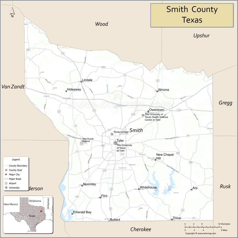
About Smith County Map, Texas: The map showing the county boundary, county seat, major cities, highways, water bodies and neighbouring counties.
Related Texas Maps
Map of Smith County, Texas
Smith County is a county located in the U.S. state of Texas. It's county seat is Tyler. As per 2020 census, the population of Smith County is 237186 people and population density is square miles. According to the United States Census Bureau, the county has a total area of 928 sq mi (2,404 km2). Smith County was established on 1846.
Facts about Smith County, Texas
| Country | United States |
| State | Texas |
| Region | East Texas / Piney Woods |
| County Seat | Tyler |
| Named After | James Smith, Texas Revolutionary officer |
| Established | 1846 |
| Organized | 1846 |
| Coordinates | 32.3750° N, 95.2690° W |
| Total Area | 928 sq mi |
| Land Area | 921 sq mi |
| Water Area | 7 sq mi |
| Population (2020) | 233,479 |
| Population Rank | Large county in East Texas |
| Major City | Tyler |
| Main Industries | Healthcare, Education, Manufacturing, Retail, Oil & Gas |
| Major Airport | Tyler Pounds Regional Airport (TYR) |
| Time Zone | Central Time (UTC−06:00) |
| Known For | Tyler Rose Garden, East Texas Oil Museum, Medical district |
| Website | https://www.smith-county.com |
Top Attractions in Smith County, Texas
- Tyler Rose Garden – Largest municipal rose garden.
- Caldwell Zoo – Family-friendly animal exhibits.
- Tyler State Park – Lake, trails, and camping.
- Downtown Tyler Square – Shops, dining, and history.
- Smith County Courthouse – Historic courthouse landmark.
- Discovery Science Place – Hands-on science museum.
- Goodman-LeGrand House – Historic home and gardens.
- Lake Palestine – Boating and fishing recreation.
- Museum of East Texas – Regional art and exhibits.
- Azalea & Spring Flower Trails – Seasonal floral displays.
Cities and Towns in Smith County, Texas
| Place | Type | Population (Census 2020) | Latitude & Longitude |
|---|---|---|---|
| Tyler (county seat) | City | 105995 | 32.3513°N, 95.3011°W |
| Lindale | City | 5818 | 32.5157°N, 95.4094°W |
| Whitehouse | City | 8545 | 32.2268°N, 95.2258°W |
| Hideaway | City | 3083 | 32.4890°N, 95.4564°W |
| Arp | City | 891 | 32.2257°N, 95.0577°W |
| New Chapel Hill | City | 594 | 32.3021°N, 95.1769°W |
| Noonday | City | 777 | 32.2260°N, 95.3905°W |
| Overton (partly in Rusk County) | City | 2554 | 32.2743°N, 94.9788°W |
| Troup (partly in Cherokee County) | City | 2006 | 32.1446°N, 95.1202°W |
| Bullard (partly in Cherokee County) | Town | 3318 | 32.1385°N, 95.3205°W |
| Winona | Town | 576 | 32.4896°N, 95.1680°W |
| Emerald Bay | Census Designated Place (CDP) | 1146 | 32.0354°N, 95.4798°W |
| Flint | Unincorporated Community | N/A | 32.2346°N, 95.3447°W |
| Gresham | Unincorporated Community | N/A | 32.2135°N, 95.3727°W |
| Garden Valley | Unincorporated Community | N/A | 32.4817°N, 95.4925°W |
| Bascom | Unincorporated Community | N/A | 32.4510°N, 95.2460°W |
| Starrville | Unincorporated Community | N/A | 32.4560°N, 95.1480°W |
What are Major Roads and Highways in Smith County
Major highways connect the county to nearby regions and cities.
- Interstate 20 - major east-west corridor connecting Tyler with Dallas, Longview, and Shreveport
- U.S. Highway 69 - north-south route linking Tyler with Lindale, Mineola, Lufkin, and Houston
- U.S. Highway 271 - connects Tyler with Gladewater, Gilmer, and Mount Pleasant
- U.S. Highway 80 - east-west route connecting Tyler with Longview and Dallas
- State Highway 31 - connects Tyler with Athens and Kilgore
- State Highway 64 - links Tyler with Henderson and Canton
- State Highway 110 - connects Tyler with Whitehouse and Jacksonville
- Loop 323 - beltway surrounding Tyler
- State Highway 155 - connects Tyler with Palestine and Gilmer
What are Neighboring Counties of Smith County
- Wood County (northwest)
- Upshur County (north)
- Gregg County (east)
- Rusk County (southeast)
- Cherokee County (south)
- Henderson County (southwest)
- Van Zandt County (west)
Distance from Smith County to Nearby Cities
The following distances are measured by road (driving).
- Tyler to Whitehouse (Smith County), Texas - 8 mi (13 km)
- Tyler to Lindale (Smith County), Texas - 14 mi (23 km)
- Tyler to Bullard (Smith County), Texas - 15 mi (24 km)
- Tyler to Troup (Smith County), Texas - 21 mi (34 km)
- Tyler to Jacksonville (Cherokee County), Texas - 27 mi (43 km)
- Tyler to Henderson (Rusk County), Texas - 35 mi (56 km)
- Tyler to Longview (Gregg County), Texas - 38 mi (61 km)
- Tyler to Mineola (Wood County), Texas - 28 mi (45 km)
- Tyler to Athens (Henderson County), Texas - 35 mi (56 km)
- Tyler to Canton (Van Zandt County), Texas - 36 mi (58 km)
- Tyler to Kilgore (Gregg County), Texas - 38 mi (61 km)
- Tyler to Palestine (Anderson County), Texas - 49 mi (79 km)
- Tyler to Marshall (Harrison County), Texas - 67 mi (108 km)
- Tyler to Dallas (Dallas County), Texas - 97 mi (156 km)
- Tyler to Shreveport, Louisiana - 98 mi (158 km)
Waterbodies in Smith County
Lake Palestine, Lake Tyler, Lake Tyler East, Sabine River, Neches River, Mud Creek, Prairie Creek, Indian Creek, Harris Creek, Flat Creek, Black Fork Creek, Bellwood Lake, Lake Tyler West, East Texas Watershed System
Best Golf Courses in Smith County, Texas
| Golf Course | Location | Latitude & Longitude |
|---|---|---|
| Cascades Golf & Country Club | Tyler | 32.3904°N, 95.2768°W |
| Hollytree Country Club | Tyler | 32.2705°N, 95.3201°W |
| Willow Brook Country Club | Tyler | 32.3435°N, 95.2504°W |
| Pine Springs Golf Course | Tyler | 32.4117°N, 95.2588°W |
| Tempest Golf Club | Gladewater | 32.5430°N, 94.9808°W |
| Hideaway Lake Club Golf Courses | Hideaway | 32.4884°N, 95.4571°W |
| Garden Valley Golf Resort | Garden Valley | 32.4920°N, 95.4842°W |
| Eagle's Bluff Country Club | Bullard | 32.0588°N, 95.4187°W |
Colleges and Universities in Smith County, Texas
Smith County is a major higher education center in East Texas. Tyler is home to public and private colleges and universities that serve students throughout the region. Smith County is also part of the Tyler metropolitan area, which supports a broad range of academic and workforce training programs. :contentReference[oaicite:0]{index=0}
| Institution Name | Type (Public/Private) | Level | Notable For |
|---|---|---|---|
| University of Texas at Tyler | Public | University | Regional public research university |
| Tyler Junior College | Public | Community College | Large community college in East Texas |
| Texas College | Private | University | Historically Black college |
| Texas A&M School of Medicine - Tyler Campus | Public | University | Medical education and health sciences |
| University Academy at UT Tyler | Public | University Affiliated | College preparatory education |
References
- U.S. Census Bureau QuickFacts - Smith County
- Smith County, Texas Overview
- Smith County Communities and Places
- Official Smith County Website
- USGS Geographic Names Information System (GNIS)
- Anderson County Map
- Andrews County Map
- Angelina County Map
- Aransas County Map
- Archer County Map
- Armstrong County Map
- Atascosa County Map
- Austin County Map
- Bailey County Map
- Bandera County Map
- Bastrop County Map
- Baylor County Map
- Bee County Map
- Bell County Map
- Bexar County Map
- Blanco County Map
- Borden County Map
- Bosque County Map
- Bowie County Map
- Brazoria County Map
- Brazos County Map
- Brewster County Map
- Briscoe County Map
- Brooks County Map
- Brown County Map
- Burleson County Map
- Burnet County Map
- Caldwell County Map
- Calhoun County Map
- Callahan County Map
- Cameron County Map
- Camp County Map
- Carson County Map
- Cass County Map
- Castro County Map
- Chambers County Map
- Cherokee County Map
- Childress County Map
- Clay County Map
- Cochran County Map
- Coke County Map
- Coleman County Map
- Collin County Map
- Collingsworth County Map
- Colorado County Map
- Comal County Map
- Comanche County Map
- Concho County Map
- Cooke County Map
- Coryell County Map
- Cottle County Map
- Crane County Map
- Crockett County Map
- Crosby County Map
- Culberson County Map
- Dallam County Map
- Dallas County Map
- Dawson County Map
- Deaf Smith County Map
- Delta County Map
- Denton County Map
- DeWitt County Map
- Dickens County Map
- Dimmit County Map
- Donley County Map
- Duval County Map
- Eastland County Map
- Ector County Map
- Edwards County Map
- Ellis County Map
- El Paso County Map
- Erath County Map
- Falls County Map
- Fannin County Map
- Fayette County Map
- Fisher County Map
- Floyd County Map
- Foard County Map
- Fort Bend County Map
- Franklin County Map
- Freestone County Map
- Frio County Map
- Gaines County Map
- Galveston County Map
- Garza County Map
- Gillespie County Map
- Glasscock County Map
- Goliad County Map
- Gonzales County Map
- Gray County Map
- Grayson County Map
- Gregg County Map
- Grimes County Map
- Guadalupe County Map
- Hale County Map
- Hall County Map
- Hamilton County Map
- Hansford County Map
- Hardeman County Map
- Hardin County Map
- Harris County Map
- Harrison County Map
- Hartley County Map
- Haskell County Map
- Hays County Map
- Hemphill County Map
- Henderson County Map
- Hidalgo County Map
- Hill County Map
- Hockley County Map
- Hood County Map
- Hopkins County Map
- Houston County Map
- Howard County Map
- Hudspeth County Map
- Hunt County Map
- Hutchinson County Map
- Irion County Map
- Jack County Map
- Jackson County Map
- Jasper County Map
- Jeff Davis County Map
- Jefferson County Map
- Jim Hogg County Map
- Jim Wells County Map
- Johnson County Map
- Jones County Map
- Karnes County Map
- Kaufman County Map
- Kendall County Map
- Kenedy County Map
- Kent County Map
- Kerr County Map
- Kimble County Map
- King County Map
- Kinney County Map
- Kleberg County Map
- Knox County Map
- Lamar County Map
- Lamb County Map
- Lampasas County Map
- La Salle County Map
- Lavaca County Map
- Lee County Map
- Leon County Map
- Liberty County Map
- Limestone County Map
- Lipscomb County Map
- Live Oak County Map
- Llano County Map
- Loving County Map
- Lubbock County Map
- Lynn County Map
- McCulloch County Map
- McLennan County Map
- McMullen County Map
- Madison County Map
- Marion County Map
- Martin County Map
- Mason County Map
- Matagorda County Map
- Maverick County Map
- Medina County Map
- Menard County Map
- Midland County Map
- Milam County Map
- Mills County Map
- Mitchell County Map
- Montague County Map
- Montgomery County Map
- Moore County Map
- Morris County Map
- Motley County Map
- Nacogdoches County Map
- Navarro County Map
- Newton County Map
- Nolan County Map
- Nueces County Map
- Ochiltree County Map
- Oldham County Map
- Orange County Map
- Palo Pinto County Map
- Panola County Map
- Parker County Map
- Parmer County Map
- Pecos County Map
- Polk County Map
- Potter County Map
- Presidio County Map
- Rains County Map
- Randall County Map
- Reagan County Map
- Real County Map
- Red River County Map
- Reeves County Map
- Refugio County Map
- Roberts County Map
- Robertson County Map
- Rockwall County Map
- Runnels County Map
- Rusk County Map
- Sabine County Map
- San Augustine County Map
- San Jacinto County Map
- San Patricio County Map
- San Saba County Map
- Schleicher County Map
- Scurry County Map
- Shackelford County Map
- Shelby County Map
- Sherman County Map
- Smith County Map
- Somervell County Map
- Starr County Map
- Stephens County Map
- Sterling County Map
- Stonewall County Map
- Sutton County Map
- Swisher County Map
- Tarrant County Map
- Taylor County Map
- Terrell County Map
- Terry County Map
- Throckmorton County Map
- Titus County Map
- Tom Green County Map
- Travis County Map
- Trinity County Map
- Tyler County Map
- Upshur County Map
- Upton County Map
- Uvalde County Map
- Val Verde County Map
- Van Zandt County Map
- Victoria County Map
- Walker County Map
- Waller County Map
- Ward County Map
- Washington County Map
- Webb County Map
- Wharton County Map
- Wheeler County Map
- Wichita County Map
- Wilbarger County Map
- Willacy County Map
- Williamson County Map
- Wilson County Map
- Winkler County Map
- Wise County Map
- Wood County Map
- Yoakum County Map
- Young County Map
- Zapata County Map
- Zavala County Map
- Alabama Counties
- Alaska boroughs
- Arizona Counties
- Arkansas Counties
- California County Map
- Colorado Counties
- Connecticut Counties
- Delaware Counties
- Florida County Map
- Georgia County Map
- Hawaii Counties
- Idaho Counties
- Illinois Counties
- Indiana Counties
- Iowa Counties
- Kansas Counties
- Kentucky Counties
- Louisiana Counties
- Maine Counties
- Maryland Counties
- Massachusetts Counties
- Michigan County Map
- Minnesota Counties
- Mississippi Counties
- Missouri Counties
- Montana Counties
- Nebraska Counties
- Nevada Counties
- New York Counties
- New Hampshire Counties
- New Jersey Counties
- New Mexico Counties
- North Carolina Counties
- North Dakota Counties
- Ohio County Map
- Oklahoma Counties
- Oregon Counties
- Pennsylvania Counties
- Rhode Island Counties
- South Carolina Counties
- South Dakota Counties
- Map of Tennessee
- Texas County Map
- Utah Counties
- Vermont Counties
- Virginia Counties
- Washington Counties
- West Virginia Counties
- Wisconsin Counties
- Wyoming Counties
References
- ^ QuickFacts: Smith County, Texas - United States Census Bureau
- ^ United States Census Bureau - Population and Housing Data
- ^ TIGER/Line Shapefiles - United States Census Bureau
- ^ United States Geological Survey (USGS)
- ^ National Geodetic Survey (NGS), NOAA
- ^ Official Website of Smith County, Texas
- ^ Texas Department of Transportation (TxDOT)