Map of Burnet County - Burnet County is a county located in the U.S. state of Texas. Burnet County Map showing cities, highways, important places and water bodies. Get Where is Burnet County located in the map, major cities in Burnet county, population, areas, and places of interest.
Map of Burnet County, Texas
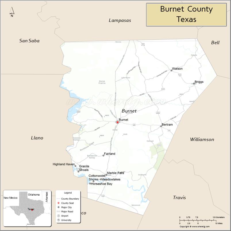
About Burnet County Map, Texas: The map showing the county boundary, county seat, major cities, highways, water bodies and neighbouring counties.
Related Texas Maps
Map of Burnet County, Texas
Burnet County is a county located in the U.S. state of Texas. It's county seat is Burnet. As per 2020 census, the population of Burnet County is 50954 people and population density is square miles. According to the United States Census Bureau, the county has a total area of 995 sq mi (2,577 km2). Burnet County was established on 1852.
Facts about Burnet County, Texas
| Country | United States |
| State | Texas |
| Region | Texas Hill Country |
| County Seat | Burnet |
| Named After | David G. Burnet, first (provisional) president of the Republic of Texas |
| Established | 1852 |
| Organized | 1854 |
| Coordinates | 30.7981° N, 98.2213° W |
| Total Area | 1,021 sq mi |
| Land Area | 995 sq mi |
| Water Area | 26 sq mi |
| Population (2020) | 49,130 |
| Population Rank | Growing Hill Country county |
| Major Cities | Burnet, Marble Falls |
| Main Industries | Tourism, Ranching, Construction, Outdoor recreation |
| Major Airport | Burnet Municipal Airport (Kate Craddock Field) |
| Time Zone | Central Time (UTC−06:00) |
| Known For | Inks Lake, Lake LBJ, Longhorn Cavern State Park, Bluebonnet trails |
| Website | https://www.burnetcountytexas.org |
Top Attractions in Burnet County, Texas
- Inks Lake State Park – Swimming, boating, hiking, and scenic Hill Country views.
- Longhorn Cavern State Park – Guided tours through dramatic underground formations.
- Lake Buchanan – Fishing, boating, and lakeside relaxation.
- Vanishing Texas River Cruise – Wildlife and waterfall cruises on Lake Buchanan.
- Downtown Burnet – Historic square with shops, cafés, and community events.
- Fort Croghan Museum – Pioneer history exhibits and preserved early structures.
- Hamilton Creek Park – Walking paths, waterfalls, and picnic areas.
- Bronte’s Books (Marble Falls) – Local bookstore in a charming historic district.
- Marble Falls Sculpture on Main – Outdoor sculpture displays along Main Street.
- Lakeside Park (Marble Falls) – Waterfront park with views of the Colorado River.
Cities and Towns in Burnet County, Texas
| Place | Type | Population (Census 2020) | Latitude & Longitude |
|---|---|---|---|
| Burnet (county seat) | City | 6436 | 30.7582°N, 98.2284°W |
| Marble Falls | City | 7956 | 30.5780°N, 98.2728°W |
| Bertram | City | 1294 | 30.7446°N, 98.0556°W |
| Cottonwood Shores | City | 1123 | 30.5560°N, 98.3251°W |
| Double Horn | City | 173 | 30.4578°N, 98.3684°W |
| Granite Shoals | City | 5863 | 30.5897°N, 98.3731°W |
| Highland Haven | City | 30.5526°N, 98.3618°W | |
| Horseshoe Bay (partly in Burnet County) | City | 4257 | 30.5438°N, 98.3614°W |
| Meadowlakes | City | 1660 | 30.5658°N, 98.2998°W |
| Briggs | Census Designated Place (CDP) | 101 | 30.8897°N, 97.9326°W |
| Fairland | Unincorporated Community | N/A | 30.6424°N, 98.2709°W |
| Joppa | Unincorporated Community | N/A | 30.8107°N, 98.1045°W |
| Lake Victor | Unincorporated Community | N/A | 30.9762°N, 98.1795°W |
| Naruna | Unincorporated Community | N/A | 31.0135°N, 98.2461°W |
| Oakalla | Unincorporated Community | N/A | 30.8118°N, 97.9274°W |
| Oatmeal | Unincorporated Community | N/A | 30.7287°N, 98.1492°W |
| Smithwick | Unincorporated Community | N/A | 30.5737°N, 98.4265°W |
| Spicewood (partly in Burnet County) | Unincorporated Community | N/A | 30.4749°N, 98.1636°W |
What are Major Roads and Highways in Burnet County
Major highways connect the county to nearby regions and cities.
- U.S. Highway 183 - north toward Lampasas and south toward Austin
- U.S. Highway 281 - north toward Lampasas and south toward Blanco
- Texas State Highway 29 - east toward Georgetown and west toward Llano
- Texas State Highway 71 - serves southern Burnet County near Spicewood
- Farm to Market Road 1431 - connects Marble Falls with Cedar Park and Lago Vista
- Farm to Market Road 963 - serves eastern Burnet County
- Farm to Market Road 1174 - links Bertram and Liberty Hill
What are Neighboring Counties of Burnet County
- Lampasas County (north)
- Bell County (northeast)
- Williamson County (east)
- Travis County (southeast)
- Blanco County (south)
- Llano County (west)
- San Saba County (northwest)
Distance from Burnet County to Nearby Cities
The following distances are measured by road (driving).
- Burnet to Marble Falls (Burnet County), Texas - 12 mi (19 km)
- Burnet to Bertram (Burnet County), Texas - 15 mi (24 km)
- Burnet to Lampasas (Lampasas County), Texas - 22 mi (35 km)
- Burnet to Llano (Llano County), Texas - 35 mi (56 km)
- Burnet to Georgetown (Williamson County), Texas - 39 mi (63 km)
- Burnet to Johnson City (Blanco County), Texas - 36 mi (58 km)
- Burnet to Liberty Hill (Williamson County), Texas - 24 mi (39 km)
- Burnet to Cedar Park (Williamson County), Texas - 43 mi (69 km)
- Burnet to Round Rock (Williamson County), Texas - 49 mi (79 km)
- Burnet to Austin (Travis County), Texas - 57 mi (92 km)
- Burnet to Killeen (Bell County), Texas - 55 mi (89 km)
- Burnet to Temple (Bell County), Texas - 67 mi (108 km)
- Burnet to Fredericksburg (Gillespie County), Texas - 64 mi (103 km)
- Burnet to Waco (McLennan County), Texas - 107 mi (172 km)
- Burnet to San Antonio (Bexar County), Texas - 104 mi (167 km)
Waterbodies in Burnet County
Lake Buchanan, Inks Lake, Lake Lyndon B. Johnson, Lake Marble Falls, Colorado River, Backbone Creek, Hamilton Creek, Delaware Creek, Cow Creek, Spring Creek, Lake Victor Creek, Inks Dam Reservoir, Buchanan Dam Reservoir, Balcones Canyonlands waterways, wetlands, springs, stock ponds, and seasonal streams
Best Golf Courses in Burnet County, Texas
| Golf Course | Location | Latitude & Longitude |
|---|---|---|
| Delaware Springs Golf Course | Burnet | 30.7731°N, 98.2469°W |
| Hidden Falls Golf Club | Meadowlakes | 30.5567°N, 98.2917°W |
| Blue Lake Golf Club | Horseshoe Bay | 30.5454°N, 98.3539°W |
| Escondido Golf and Lake Club | Horseshoe Bay | 30.5426°N, 98.3926°W |
| Horseshoe Bay Resort - Apple Rock Course | Horseshoe Bay | 30.5488°N, 98.3672°W |
| Horseshoe Bay Resort - Ram Rock Course | Horseshoe Bay | 30.5408°N, 98.3494°W |
| Horseshoe Bay Resort - Slick Rock Course | Horseshoe Bay | 30.5435°N, 98.3592°W |
| Horseshoe Bay Resort - Summit Rock Course | Horseshoe Bay | 30.5664°N, 98.3871°W |
Colleges and Universities in Burnet County, Texas
| Institution Name | Type | Level | Notable For |
|---|---|---|---|
| Central Texas College - Burnet County Service Area | Public | Community College | Academic transfer and workforce programs |
| Temple College - Burnet County Service Area | Public | Community College | Continuing education and workforce training |
| Texas A&M AgriLife Extension Service - Burnet County | Public | University | Agricultural and community education programs |
References
- U.S. Census Bureau - Burnet County QuickFacts
- Official Burnet County Website
- Texas State Historical Association - Burnet County
- Delaware Springs Golf Course
- GolfPass - Burnet Area Golf Courses
- Anderson County Map
- Andrews County Map
- Angelina County Map
- Aransas County Map
- Archer County Map
- Armstrong County Map
- Atascosa County Map
- Austin County Map
- Bailey County Map
- Bandera County Map
- Bastrop County Map
- Baylor County Map
- Bee County Map
- Bell County Map
- Bexar County Map
- Blanco County Map
- Borden County Map
- Bosque County Map
- Bowie County Map
- Brazoria County Map
- Brazos County Map
- Brewster County Map
- Briscoe County Map
- Brooks County Map
- Brown County Map
- Burleson County Map
- Burnet County Map
- Caldwell County Map
- Calhoun County Map
- Callahan County Map
- Cameron County Map
- Camp County Map
- Carson County Map
- Cass County Map
- Castro County Map
- Chambers County Map
- Cherokee County Map
- Childress County Map
- Clay County Map
- Cochran County Map
- Coke County Map
- Coleman County Map
- Collin County Map
- Collingsworth County Map
- Colorado County Map
- Comal County Map
- Comanche County Map
- Concho County Map
- Cooke County Map
- Coryell County Map
- Cottle County Map
- Crane County Map
- Crockett County Map
- Crosby County Map
- Culberson County Map
- Dallam County Map
- Dallas County Map
- Dawson County Map
- Deaf Smith County Map
- Delta County Map
- Denton County Map
- DeWitt County Map
- Dickens County Map
- Dimmit County Map
- Donley County Map
- Duval County Map
- Eastland County Map
- Ector County Map
- Edwards County Map
- Ellis County Map
- El Paso County Map
- Erath County Map
- Falls County Map
- Fannin County Map
- Fayette County Map
- Fisher County Map
- Floyd County Map
- Foard County Map
- Fort Bend County Map
- Franklin County Map
- Freestone County Map
- Frio County Map
- Gaines County Map
- Galveston County Map
- Garza County Map
- Gillespie County Map
- Glasscock County Map
- Goliad County Map
- Gonzales County Map
- Gray County Map
- Grayson County Map
- Gregg County Map
- Grimes County Map
- Guadalupe County Map
- Hale County Map
- Hall County Map
- Hamilton County Map
- Hansford County Map
- Hardeman County Map
- Hardin County Map
- Harris County Map
- Harrison County Map
- Hartley County Map
- Haskell County Map
- Hays County Map
- Hemphill County Map
- Henderson County Map
- Hidalgo County Map
- Hill County Map
- Hockley County Map
- Hood County Map
- Hopkins County Map
- Houston County Map
- Howard County Map
- Hudspeth County Map
- Hunt County Map
- Hutchinson County Map
- Irion County Map
- Jack County Map
- Jackson County Map
- Jasper County Map
- Jeff Davis County Map
- Jefferson County Map
- Jim Hogg County Map
- Jim Wells County Map
- Johnson County Map
- Jones County Map
- Karnes County Map
- Kaufman County Map
- Kendall County Map
- Kenedy County Map
- Kent County Map
- Kerr County Map
- Kimble County Map
- King County Map
- Kinney County Map
- Kleberg County Map
- Knox County Map
- Lamar County Map
- Lamb County Map
- Lampasas County Map
- La Salle County Map
- Lavaca County Map
- Lee County Map
- Leon County Map
- Liberty County Map
- Limestone County Map
- Lipscomb County Map
- Live Oak County Map
- Llano County Map
- Loving County Map
- Lubbock County Map
- Lynn County Map
- McCulloch County Map
- McLennan County Map
- McMullen County Map
- Madison County Map
- Marion County Map
- Martin County Map
- Mason County Map
- Matagorda County Map
- Maverick County Map
- Medina County Map
- Menard County Map
- Midland County Map
- Milam County Map
- Mills County Map
- Mitchell County Map
- Montague County Map
- Montgomery County Map
- Moore County Map
- Morris County Map
- Motley County Map
- Nacogdoches County Map
- Navarro County Map
- Newton County Map
- Nolan County Map
- Nueces County Map
- Ochiltree County Map
- Oldham County Map
- Orange County Map
- Palo Pinto County Map
- Panola County Map
- Parker County Map
- Parmer County Map
- Pecos County Map
- Polk County Map
- Potter County Map
- Presidio County Map
- Rains County Map
- Randall County Map
- Reagan County Map
- Real County Map
- Red River County Map
- Reeves County Map
- Refugio County Map
- Roberts County Map
- Robertson County Map
- Rockwall County Map
- Runnels County Map
- Rusk County Map
- Sabine County Map
- San Augustine County Map
- San Jacinto County Map
- San Patricio County Map
- San Saba County Map
- Schleicher County Map
- Scurry County Map
- Shackelford County Map
- Shelby County Map
- Sherman County Map
- Smith County Map
- Somervell County Map
- Starr County Map
- Stephens County Map
- Sterling County Map
- Stonewall County Map
- Sutton County Map
- Swisher County Map
- Tarrant County Map
- Taylor County Map
- Terrell County Map
- Terry County Map
- Throckmorton County Map
- Titus County Map
- Tom Green County Map
- Travis County Map
- Trinity County Map
- Tyler County Map
- Upshur County Map
- Upton County Map
- Uvalde County Map
- Val Verde County Map
- Van Zandt County Map
- Victoria County Map
- Walker County Map
- Waller County Map
- Ward County Map
- Washington County Map
- Webb County Map
- Wharton County Map
- Wheeler County Map
- Wichita County Map
- Wilbarger County Map
- Willacy County Map
- Williamson County Map
- Wilson County Map
- Winkler County Map
- Wise County Map
- Wood County Map
- Yoakum County Map
- Young County Map
- Zapata County Map
- Zavala County Map
- Alabama Counties
- Alaska boroughs
- Arizona Counties
- Arkansas Counties
- California County Map
- Colorado Counties
- Connecticut Counties
- Delaware Counties
- Florida County Map
- Georgia County Map
- Hawaii Counties
- Idaho Counties
- Illinois Counties
- Indiana Counties
- Iowa Counties
- Kansas Counties
- Kentucky Counties
- Louisiana Counties
- Maine Counties
- Maryland Counties
- Massachusetts Counties
- Michigan County Map
- Minnesota Counties
- Mississippi Counties
- Missouri Counties
- Montana Counties
- Nebraska Counties
- Nevada Counties
- New York Counties
- New Hampshire Counties
- New Jersey Counties
- New Mexico Counties
- North Carolina Counties
- North Dakota Counties
- Ohio County Map
- Oklahoma Counties
- Oregon Counties
- Pennsylvania Counties
- Rhode Island Counties
- South Carolina Counties
- South Dakota Counties
- Map of Tennessee
- Texas County Map
- Utah Counties
- Vermont Counties
- Virginia Counties
- Washington Counties
- West Virginia Counties
- Wisconsin Counties
- Wyoming Counties
References
- ^ QuickFacts: Burnet County, Texas - United States Census Bureau
- ^ United States Census Bureau - Population and Housing Data
- ^ TIGER/Line Shapefiles - United States Census Bureau
- ^ United States Geological Survey (USGS)
- ^ National Geodetic Survey (NGS), NOAA
- ^ Official Website of Burnet County, Texas
- ^ Texas Department of Transportation (TxDOT)