Map of Upshur County - Upshur County is a county located in the U.S. state of Texas. Upshur County Map showing cities, highways, important places and water bodies. Get Where is Upshur County located in the map, major cities in Upshur county, population, areas, and places of interest.
Map of Upshur County, Texas
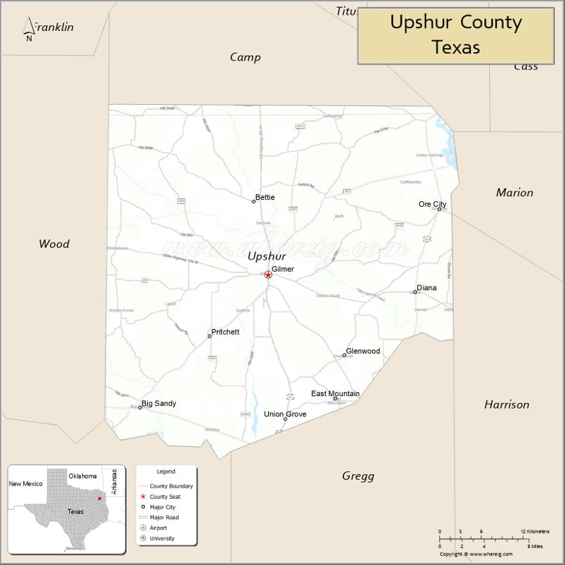
About Upshur County Map, Texas: The map showing the county boundary, county seat, major cities, highways, water bodies and neighbouring counties.
Related Texas Maps
Map of Upshur County, Texas
Upshur County is a county located in the U.S. state of Texas. It's county seat is Gilmer. As per 2020 census, the population of Upshur County is 41774 people and population density is square miles. According to the United States Census Bureau, the county has a total area of 588 sq mi (1,523 km2). Upshur County was established on 1846.
Facts about Upshur County, Texas
| Country | United States |
| State | Texas |
| Region | Northeast Texas / Piney Woods |
| County Seat | Gilmer |
| Named After | Abel Parker Upshur, U.S. Secretary of State |
| Established | 1846 |
| Organized | 1846 |
| Coordinates | 32.7360° N, 94.9410° W |
| Total Area | 587 sq mi |
| Land Area | 582 sq mi |
| Water Area | 5 sq mi |
| Population (2020) | 41,753 |
| Population Rank | Mid-sized county in Northeast Texas |
| Major City | Gilmer |
| Main Industries | Manufacturing, Forestry, Agriculture, Healthcare, Retail |
| Major Airport | Gilmer Municipal Airport (local) |
| Time Zone | Central Time (UTC−06:00) |
| Known For | East Texas Yamboree, Piney Woods scenery, Lake recreation |
| Website | https://www.co.upshur.tx.us |
Top Attractions in Upshur County, Texas
- Lake Gilmer – Fishing, boating, and scenic lake views.
- Downtown Gilmer Square – Shops, dining, and local charm.
- Upshur County Courthouse – Historic courthouse landmark.
- East Texas Yamboree Grounds – Annual festival and events.
- Gilmer Historical Museum – Local history exhibits.
- Mathis Arboretum – Native trees and walking paths.
- McClelland Creek Trail – Scenic walking trail.
- Local Fishing Ponds – Quiet outdoor recreation spots.
- Piney Woods Scenic Drives – Forested countryside routes.
- Community Parks – Green space and picnicking.
Cities and Towns in Upshur County, Texas
| Place | Type | Population (Census 2020) | Latitude & Longitude |
|---|---|---|---|
| Gilmer (county seat) | City | 5216 | 32.7287°N, 94.9424°W |
| Gladewater (partly in Gregg County) | City | 6134 | 32.5365°N, 94.9427°W |
| Big Sandy | Town | 1343 | 32.5835°N, 95.1086°W |
| Ore City | City | 1108 | 32.7993°N, 94.7208°W |
| Union Grove | City | 357 | 32.6696°N, 94.9841°W |
| East Mountain | City | 797 | 32.6685°N, 94.8616°W |
| Clarksville City | City | 830 | 32.5251°N, 94.8613°W |
| Warren City | City | 275 | 32.5682°N, 94.8924°W |
| Diana | Census Designated Place (CDP) | 1344 | 32.7568°N, 94.7522°W |
| Coffeeville | Unincorporated Community | N/A | 32.8154°N, 95.0461°W |
| Enoch | Unincorporated Community | N/A | 32.7038°N, 94.6919°W |
| Kelsey | Unincorporated Community | N/A | 32.6338°N, 94.8585°W |
| Rhonesboro | Unincorporated Community | N/A | 32.7818°N, 95.1527°W |
| Simpsonville | Unincorporated Community | N/A | 32.8307°N, 94.8838°W |
| Bettie | Unincorporated Community | N/A | 32.7031°N, 94.8896°W |
| Pritchett | Unincorporated Community | N/A | 32.6824°N, 95.0732°W |
What are Major Roads and Highways in Upshur County
Major highways connect the county to nearby regions and cities.
- U.S. Highway 80 - east-west route connecting Gladewater, Longview, and Mineola
- U.S. Highway 259 - north-south corridor connecting Ore City, Gilmer, Longview, and Oklahoma
- U.S. Highway 271 - connects Gilmer with Pittsburg, Tyler, and Mount Pleasant
- State Highway 154 - links Gilmer with Quitman and Sulphur Springs
- State Highway 155 - connects Gilmer with Tyler and Linden
- State Highway 300 - provides access between Gilmer and Longview
- Farm to Market Road 852 - serves northern Upshur County communities
- Farm to Market Road 726 - connects rural communities and agricultural areas
What are Neighboring Counties of Upshur County
- Camp County (north)
- Morris County (northeast)
- Marion County (east)
- Harrison County (southeast)
- Gregg County (south)
- Smith County (southwest)
- Wood County (west)
Distance from Upshur County to Nearby Cities
The following distances are measured by road (driving).
- Gilmer to Gladewater (Upshur County), Texas - 14 mi (23 km)
- Gilmer to Big Sandy (Upshur County), Texas - 18 mi (29 km)
- Gilmer to Ore City (Upshur County), Texas - 14 mi (23 km)
- Gilmer to Pittsburg (Camp County), Texas - 22 mi (35 km)
- Gilmer to Daingerfield (Morris County), Texas - 31 mi (50 km)
- Gilmer to Jefferson (Marion County), Texas - 34 mi (55 km)
- Gilmer to Marshall (Harrison County), Texas - 35 mi (56 km)
- Gilmer to Longview (Gregg County), Texas - 20 mi (32 km)
- Gilmer to Tyler (Smith County), Texas - 35 mi (56 km)
- Gilmer to Mineola (Wood County), Texas - 37 mi (60 km)
- Gilmer to Mount Pleasant (Titus County), Texas - 34 mi (55 km)
- Gilmer to Kilgore (Gregg County), Texas - 28 mi (45 km)
- Gilmer to Texarkana (Bowie County), Texas - 82 mi (132 km)
- Gilmer to Dallas (Dallas County), Texas - 122 mi (196 km)
- Gilmer to Shreveport, Louisiana - 66 mi (106 km)
Waterbodies in Upshur County
Big Cypress Creek, Little Cypress Creek, Lake Gilmer, Lake O' the Pines, Sabine River, Ellison Creek Reservoir, Coffeeville Creek, Kelsey Creek, Grice Creek, White Oak Creek, Little White Oak Creek, Simpsonville Creek, Cypress River Basin, Lake Gilmer Watershed
Best Golf Courses in Upshur County, Texas
| Golf Course | Location | Latitude & Longitude |
|---|---|---|
| Gilmer Country Club | Gilmer | 32.7281°N, 94.9604°W |
| Oak Forest Country Club | Gilmer | 32.7352°N, 94.9748°W |
| Tempest Golf Club | Gladewater | 32.5575°N, 94.9202°W |
Colleges and Universities in Upshur County, Texas
| Institution Name | Type (Public/Private) | Level | Notable For |
|---|---|---|---|
| Kilgore College | Public | Community College | Primary community college serving much of the county |
| Northeast Texas Community College | Public | Community College | Serves portions of northern Upshur County |
| LeTourneau University | Private | University | Engineering and aviation programs |
| University of Texas at Tyler | Public | University | Regional public university |
| Texas A&M University-Texarkana | Public | University | Higher education for Northeast Texas |
References
- U.S. Census Bureau QuickFacts - Upshur County
- Official Upshur County Website
- Texas State Historical Association - Upshur County
- USGS Geographic Names Information System (GNIS)
- Kilgore College
- Anderson County Map
- Andrews County Map
- Angelina County Map
- Aransas County Map
- Archer County Map
- Armstrong County Map
- Atascosa County Map
- Austin County Map
- Bailey County Map
- Bandera County Map
- Bastrop County Map
- Baylor County Map
- Bee County Map
- Bell County Map
- Bexar County Map
- Blanco County Map
- Borden County Map
- Bosque County Map
- Bowie County Map
- Brazoria County Map
- Brazos County Map
- Brewster County Map
- Briscoe County Map
- Brooks County Map
- Brown County Map
- Burleson County Map
- Burnet County Map
- Caldwell County Map
- Calhoun County Map
- Callahan County Map
- Cameron County Map
- Camp County Map
- Carson County Map
- Cass County Map
- Castro County Map
- Chambers County Map
- Cherokee County Map
- Childress County Map
- Clay County Map
- Cochran County Map
- Coke County Map
- Coleman County Map
- Collin County Map
- Collingsworth County Map
- Colorado County Map
- Comal County Map
- Comanche County Map
- Concho County Map
- Cooke County Map
- Coryell County Map
- Cottle County Map
- Crane County Map
- Crockett County Map
- Crosby County Map
- Culberson County Map
- Dallam County Map
- Dallas County Map
- Dawson County Map
- Deaf Smith County Map
- Delta County Map
- Denton County Map
- DeWitt County Map
- Dickens County Map
- Dimmit County Map
- Donley County Map
- Duval County Map
- Eastland County Map
- Ector County Map
- Edwards County Map
- Ellis County Map
- El Paso County Map
- Erath County Map
- Falls County Map
- Fannin County Map
- Fayette County Map
- Fisher County Map
- Floyd County Map
- Foard County Map
- Fort Bend County Map
- Franklin County Map
- Freestone County Map
- Frio County Map
- Gaines County Map
- Galveston County Map
- Garza County Map
- Gillespie County Map
- Glasscock County Map
- Goliad County Map
- Gonzales County Map
- Gray County Map
- Grayson County Map
- Gregg County Map
- Grimes County Map
- Guadalupe County Map
- Hale County Map
- Hall County Map
- Hamilton County Map
- Hansford County Map
- Hardeman County Map
- Hardin County Map
- Harris County Map
- Harrison County Map
- Hartley County Map
- Haskell County Map
- Hays County Map
- Hemphill County Map
- Henderson County Map
- Hidalgo County Map
- Hill County Map
- Hockley County Map
- Hood County Map
- Hopkins County Map
- Houston County Map
- Howard County Map
- Hudspeth County Map
- Hunt County Map
- Hutchinson County Map
- Irion County Map
- Jack County Map
- Jackson County Map
- Jasper County Map
- Jeff Davis County Map
- Jefferson County Map
- Jim Hogg County Map
- Jim Wells County Map
- Johnson County Map
- Jones County Map
- Karnes County Map
- Kaufman County Map
- Kendall County Map
- Kenedy County Map
- Kent County Map
- Kerr County Map
- Kimble County Map
- King County Map
- Kinney County Map
- Kleberg County Map
- Knox County Map
- Lamar County Map
- Lamb County Map
- Lampasas County Map
- La Salle County Map
- Lavaca County Map
- Lee County Map
- Leon County Map
- Liberty County Map
- Limestone County Map
- Lipscomb County Map
- Live Oak County Map
- Llano County Map
- Loving County Map
- Lubbock County Map
- Lynn County Map
- McCulloch County Map
- McLennan County Map
- McMullen County Map
- Madison County Map
- Marion County Map
- Martin County Map
- Mason County Map
- Matagorda County Map
- Maverick County Map
- Medina County Map
- Menard County Map
- Midland County Map
- Milam County Map
- Mills County Map
- Mitchell County Map
- Montague County Map
- Montgomery County Map
- Moore County Map
- Morris County Map
- Motley County Map
- Nacogdoches County Map
- Navarro County Map
- Newton County Map
- Nolan County Map
- Nueces County Map
- Ochiltree County Map
- Oldham County Map
- Orange County Map
- Palo Pinto County Map
- Panola County Map
- Parker County Map
- Parmer County Map
- Pecos County Map
- Polk County Map
- Potter County Map
- Presidio County Map
- Rains County Map
- Randall County Map
- Reagan County Map
- Real County Map
- Red River County Map
- Reeves County Map
- Refugio County Map
- Roberts County Map
- Robertson County Map
- Rockwall County Map
- Runnels County Map
- Rusk County Map
- Sabine County Map
- San Augustine County Map
- San Jacinto County Map
- San Patricio County Map
- San Saba County Map
- Schleicher County Map
- Scurry County Map
- Shackelford County Map
- Shelby County Map
- Sherman County Map
- Smith County Map
- Somervell County Map
- Starr County Map
- Stephens County Map
- Sterling County Map
- Stonewall County Map
- Sutton County Map
- Swisher County Map
- Tarrant County Map
- Taylor County Map
- Terrell County Map
- Terry County Map
- Throckmorton County Map
- Titus County Map
- Tom Green County Map
- Travis County Map
- Trinity County Map
- Tyler County Map
- Upshur County Map
- Upton County Map
- Uvalde County Map
- Val Verde County Map
- Van Zandt County Map
- Victoria County Map
- Walker County Map
- Waller County Map
- Ward County Map
- Washington County Map
- Webb County Map
- Wharton County Map
- Wheeler County Map
- Wichita County Map
- Wilbarger County Map
- Willacy County Map
- Williamson County Map
- Wilson County Map
- Winkler County Map
- Wise County Map
- Wood County Map
- Yoakum County Map
- Young County Map
- Zapata County Map
- Zavala County Map
- Alabama Counties
- Alaska boroughs
- Arizona Counties
- Arkansas Counties
- California County Map
- Colorado Counties
- Connecticut Counties
- Delaware Counties
- Florida County Map
- Georgia County Map
- Hawaii Counties
- Idaho Counties
- Illinois Counties
- Indiana Counties
- Iowa Counties
- Kansas Counties
- Kentucky Counties
- Louisiana Counties
- Maine Counties
- Maryland Counties
- Massachusetts Counties
- Michigan County Map
- Minnesota Counties
- Mississippi Counties
- Missouri Counties
- Montana Counties
- Nebraska Counties
- Nevada Counties
- New York Counties
- New Hampshire Counties
- New Jersey Counties
- New Mexico Counties
- North Carolina Counties
- North Dakota Counties
- Ohio County Map
- Oklahoma Counties
- Oregon Counties
- Pennsylvania Counties
- Rhode Island Counties
- South Carolina Counties
- South Dakota Counties
- Map of Tennessee
- Texas County Map
- Utah Counties
- Vermont Counties
- Virginia Counties
- Washington Counties
- West Virginia Counties
- Wisconsin Counties
- Wyoming Counties
References
- ^ QuickFacts: Upshur County, Texas - United States Census Bureau
- ^ United States Census Bureau - Population and Housing Data
- ^ TIGER/Line Shapefiles - United States Census Bureau
- ^ United States Geological Survey (USGS)
- ^ National Geodetic Survey (NGS), NOAA
- ^ Official Website of Upshur County, Texas
- ^ Texas Department of Transportation (TxDOT)