Map of Travis County - Travis County is a county located in the U.S. state of Texas. Travis County Map showing cities, highways, important places and water bodies. Get Where is Travis County located in the map, major cities in Travis county, population, areas, and places of interest.
Map of Travis County, Texas
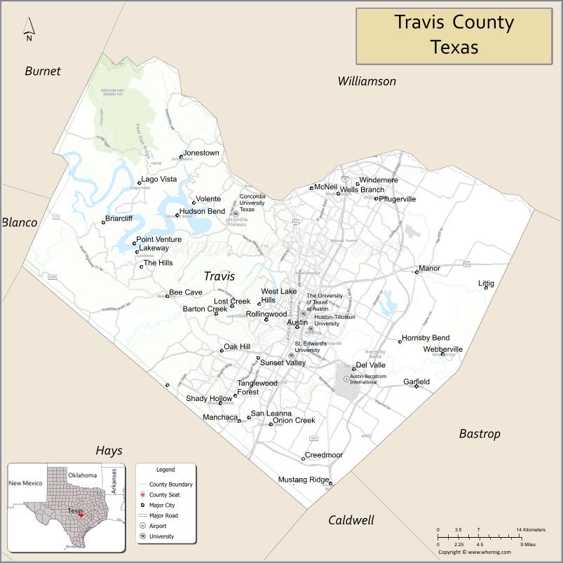
About Travis County Map, Texas: The map showing the county boundary, county seat, major cities, highways, water bodies and neighbouring counties.
Related Texas Maps
Map of Travis County, Texas
Travis County is a county located in the U.S. state of Texas. It's county seat is Austin. As per 2020 census, the population of Travis County is 1305154 people and population density is square miles. According to the United States Census Bureau, the county has a total area of 989 sq mi (2,561 km2). Travis County was established on 1840.
Facts about Travis County, Texas
| Country | United States |
| State | Texas |
| Region | Central Texas |
| County Seat | Austin |
| Named After | William B. Travis, commander at the Battle of the Alamo |
| Established | 1840 |
| Organized | 1840 |
| Coordinates | 30.2672° N, 97.7431° W |
| Total Area | 1,023 sq mi |
| Land Area | 990 sq mi |
| Water Area | 33 sq mi |
| Population (2020) | 1,290,188 |
| Population Rank | One of the most populous counties in Texas |
| Major City | Austin |
| Main Industries | Technology, Government, Education, Healthcare, Music & Entertainment |
| Major Airport | Austin-Bergstrom International Airport (AUS) |
| Time Zone | Central Time (UTC−06:00) |
| Known For | Texas State Capitol, Live music scene, Tech innovation hub |
| Website | https://www.traviscountytx.gov |
Top Attractions in Travis County, Texas
- Texas State Capitol – Iconic state government building.
- Zilker Metropolitan Park – Green space, trails, and events.
- Barton Springs Pool – Natural spring-fed swimming pool.
- Lady Bird Lake – Kayaking, trails, and skyline views.
- South Congress Avenue – Shops, music, and dining.
- Mount Bonnell – Scenic overlook of the Colorado River.
- LBJ Presidential Library – Presidential history and exhibits.
- Bullock Texas State History Museum – Texas history displays.
- Sixth Street Entertainment District – Live music and nightlife.
- McKinney Falls State Park – Waterfalls and hiking trails.
Cities and Towns in Travis County, Texas
| Place | Type | Population (Census 2020) | Latitude & Longitude |
|---|---|---|---|
| Austin (county seat) | City | 961855 | 30.2672°N, 97.7431°W |
| Bee Cave | City | 9144 | 30.3085°N, 97.9528°W |
| Creedmoor | City | 202 | 30.0891°N, 97.7392°W |
| Jonestown | City | 2365 | 30.4952°N, 97.9245°W |
| Lago Vista | City | 8912 | 30.4627°N, 97.9889°W |
| Lakeway | City | 19189 | 30.3638°N, 97.9792°W |
| Manor | City | 13575 | 30.3408°N, 97.5569°W |
| Pflugerville | City | 65191 | 30.4394°N, 97.6200°W |
| Rollingwood | City | 1467 | 30.2769°N, 97.7928°W |
| Sunset Valley | City | 749 | 30.2280°N, 97.8178°W |
| West Lake Hills | City | 3332 | 30.2977°N, 97.8011°W |
| Volente | Village | 570 | 30.4449°N, 97.9186°W |
| Webberville | Village | 394 | 30.2308°N, 97.4922°W |
| Barton Creek | Census Designated Place (CDP) | 3120 | 30.2857°N, 97.8695°W |
| Briarcliff | Census Designated Place (CDP) | 1438 | 30.4077°N, 98.0448°W |
| Jollyville | Census Designated Place (CDP) | 16581 | 30.4471°N, 97.7689°W |
| Lost Creek | Census Designated Place (CDP) | 4509 | 30.2950°N, 97.8468°W |
| Shady Hollow | Census Designated Place (CDP) | 5004 | 30.1748°N, 97.8739°W |
| Wells Branch | Census Designated Place (CDP) | 12428 | 30.4429°N, 97.6794°W |
| Del Valle | Census Designated Place (CDP) | 1738 | 30.2127°N, 97.6578°W |
| Hudson Bend | Census Designated Place (CDP) | 3088 | 30.4157°N, 97.9298°W |
| Garfield | Unincorporated Community | N/A | 30.1891°N, 97.5572°W |
| Oak Hill | Unincorporated Community | N/A | 30.2366°N, 97.8753°W |
| Spicewood | Unincorporated Community (partly in Travis County) | N/A | 30.4855°N, 98.1589°W |
What are Major Roads and Highways in Travis County
Major highways connect the county to nearby regions and cities.
- Interstate 35 - major north-south corridor through Austin connecting Dallas, Waco, San Antonio, and Laredo
- State Highway 130 - toll route bypassing central Austin and connecting Georgetown with Seguin
- U.S. Highway 183 - connects Austin with Lockhart, Lampasas, and the Austin airport area
- U.S. Highway 290 - east-west route linking Austin with Houston and Fredericksburg
- State Highway 71 - connects Austin with Bastrop, Marble Falls, and the Hill Country
- Loop 1 (MoPac Expressway) - major north-south route through western Austin
- Loop 360 (Capital of Texas Highway) - scenic route through western Travis County
- State Highway 45 - toll road connecting Travis and Williamson counties
- Farm to Market Road 620 - serves Lake Travis communities
- Farm to Market Road 2222 - connects central Austin with western suburbs
What are Neighboring Counties of Travis County
- Williamson County (north)
- Bastrop County (east)
- Caldwell County (southeast)
- Hays County (south)
- Blanco County (southwest)
- Burnet County (northwest)
Distance from Travis County to Nearby Cities
The following distances are measured by road (driving).
- Austin to Pflugerville (Travis County), Texas - 17 mi (27 km)
- Austin to Manor (Travis County), Texas - 14 mi (23 km)
- Austin to Lakeway (Travis County), Texas - 23 mi (37 km)
- Austin to Bee Cave (Travis County), Texas - 17 mi (27 km)
- Austin to Round Rock (Williamson County), Texas - 20 mi (32 km)
- Austin to Georgetown (Williamson County), Texas - 31 mi (50 km)
- Austin to Bastrop (Bastrop County), Texas - 33 mi (53 km)
- Austin to San Marcos (Hays County), Texas - 31 mi (50 km)
- Austin to Lockhart (Caldwell County), Texas - 33 mi (53 km)
- Austin to Marble Falls (Burnet County), Texas - 48 mi (77 km)
- Austin to Johnson City (Blanco County), Texas - 49 mi (79 km)
- Austin to New Braunfels (Comal County), Texas - 50 mi (80 km)
- Austin to Killeen (Bell County), Texas - 70 mi (113 km)
- Austin to Temple (Bell County), Texas - 74 mi (119 km)
- Austin to San Antonio (Bexar County), Texas - 80 mi (129 km)
Waterbodies in Travis County
Colorado River, Lake Travis, Lady Bird Lake, Lake Austin, Walter E. Long Lake, Barton Creek, Onion Creek, Bull Creek, Walnut Creek, Shoal Creek, Little Walnut Creek, Boggy Creek, Barton Springs, Hamilton Creek, Lake Austin Watershed
Best Golf Courses in Travis County, Texas
| Golf Course | Location | Latitude & Longitude |
|---|---|---|
| Austin Country Club | Austin | 30.3360°N, 97.8683°W |
| Barton Creek Fazio Canyons Golf Course | Austin | 30.3291°N, 97.9395°W |
| Barton Creek Coore Crenshaw Golf Course | Austin | 30.3248°N, 97.9492°W |
| Barton Creek Foothills Golf Course | Austin | 30.3232°N, 97.9418°W |
| Barton Creek Lakeside Golf Club | Spicewood | 30.4942°N, 98.1018°W |
| Falconhead Golf Club | Bee Cave | 30.3128°N, 97.9861°W |
| Grey Rock Golf Club | Austin | 30.1402°N, 97.8679°W |
| Lions Municipal Golf Course | Austin | 30.2899°N, 97.7794°W |
| Morris Williams Golf Course | Austin | 30.2797°N, 97.7063°W |
| Jimmy Clay Golf Course | Austin | 30.1715°N, 97.7446°W |
| Roy Kizer Golf Course | Austin | 30.1658°N, 97.7399°W |
| Riverside Golf Course | Austin | 30.2465°N, 97.6984°W |
| Harvey Penick Golf Campus | Austin | 30.2791°N, 97.6397°W |
| Lakecliff Golf Club | Spicewood | 30.4548°N, 98.0678°W |
| The Hills Country Club | The Hills | 30.3474°N, 97.9951°W |
| Spanish Oaks Golf Club | Bee Cave | 30.3049°N, 97.9927°W |
Colleges and Universities in Travis County, Texas
| Institution Name | Type (Public/Private) | Level | Notable For |
|---|---|---|---|
| University of Texas at Austin | Public | University | Flagship public research university |
| St. Edward's University | Private | University | Catholic liberal arts education |
| Concordia University Texas | Private | University | Lutheran-affiliated higher education |
| Huston-Tillotson University | Private | University | Historically Black university |
| Austin Community College District | Public | Community College | Large multi-campus community college system |
| Texas Health and Science University | Private | University | Traditional Chinese medicine programs |
| South University - Austin | Private | University | Professional and graduate programs |
References
- U.S. Census Bureau QuickFacts - Travis County
- U.S. Census Bureau - 2020 Census Data for Travis County Communities
- Official Travis County Website
- City of Austin Official Website
- USGS Geographic Names Information System (GNIS)
- Anderson County Map
- Andrews County Map
- Angelina County Map
- Aransas County Map
- Archer County Map
- Armstrong County Map
- Atascosa County Map
- Austin County Map
- Bailey County Map
- Bandera County Map
- Bastrop County Map
- Baylor County Map
- Bee County Map
- Bell County Map
- Bexar County Map
- Blanco County Map
- Borden County Map
- Bosque County Map
- Bowie County Map
- Brazoria County Map
- Brazos County Map
- Brewster County Map
- Briscoe County Map
- Brooks County Map
- Brown County Map
- Burleson County Map
- Burnet County Map
- Caldwell County Map
- Calhoun County Map
- Callahan County Map
- Cameron County Map
- Camp County Map
- Carson County Map
- Cass County Map
- Castro County Map
- Chambers County Map
- Cherokee County Map
- Childress County Map
- Clay County Map
- Cochran County Map
- Coke County Map
- Coleman County Map
- Collin County Map
- Collingsworth County Map
- Colorado County Map
- Comal County Map
- Comanche County Map
- Concho County Map
- Cooke County Map
- Coryell County Map
- Cottle County Map
- Crane County Map
- Crockett County Map
- Crosby County Map
- Culberson County Map
- Dallam County Map
- Dallas County Map
- Dawson County Map
- Deaf Smith County Map
- Delta County Map
- Denton County Map
- DeWitt County Map
- Dickens County Map
- Dimmit County Map
- Donley County Map
- Duval County Map
- Eastland County Map
- Ector County Map
- Edwards County Map
- Ellis County Map
- El Paso County Map
- Erath County Map
- Falls County Map
- Fannin County Map
- Fayette County Map
- Fisher County Map
- Floyd County Map
- Foard County Map
- Fort Bend County Map
- Franklin County Map
- Freestone County Map
- Frio County Map
- Gaines County Map
- Galveston County Map
- Garza County Map
- Gillespie County Map
- Glasscock County Map
- Goliad County Map
- Gonzales County Map
- Gray County Map
- Grayson County Map
- Gregg County Map
- Grimes County Map
- Guadalupe County Map
- Hale County Map
- Hall County Map
- Hamilton County Map
- Hansford County Map
- Hardeman County Map
- Hardin County Map
- Harris County Map
- Harrison County Map
- Hartley County Map
- Haskell County Map
- Hays County Map
- Hemphill County Map
- Henderson County Map
- Hidalgo County Map
- Hill County Map
- Hockley County Map
- Hood County Map
- Hopkins County Map
- Houston County Map
- Howard County Map
- Hudspeth County Map
- Hunt County Map
- Hutchinson County Map
- Irion County Map
- Jack County Map
- Jackson County Map
- Jasper County Map
- Jeff Davis County Map
- Jefferson County Map
- Jim Hogg County Map
- Jim Wells County Map
- Johnson County Map
- Jones County Map
- Karnes County Map
- Kaufman County Map
- Kendall County Map
- Kenedy County Map
- Kent County Map
- Kerr County Map
- Kimble County Map
- King County Map
- Kinney County Map
- Kleberg County Map
- Knox County Map
- Lamar County Map
- Lamb County Map
- Lampasas County Map
- La Salle County Map
- Lavaca County Map
- Lee County Map
- Leon County Map
- Liberty County Map
- Limestone County Map
- Lipscomb County Map
- Live Oak County Map
- Llano County Map
- Loving County Map
- Lubbock County Map
- Lynn County Map
- McCulloch County Map
- McLennan County Map
- McMullen County Map
- Madison County Map
- Marion County Map
- Martin County Map
- Mason County Map
- Matagorda County Map
- Maverick County Map
- Medina County Map
- Menard County Map
- Midland County Map
- Milam County Map
- Mills County Map
- Mitchell County Map
- Montague County Map
- Montgomery County Map
- Moore County Map
- Morris County Map
- Motley County Map
- Nacogdoches County Map
- Navarro County Map
- Newton County Map
- Nolan County Map
- Nueces County Map
- Ochiltree County Map
- Oldham County Map
- Orange County Map
- Palo Pinto County Map
- Panola County Map
- Parker County Map
- Parmer County Map
- Pecos County Map
- Polk County Map
- Potter County Map
- Presidio County Map
- Rains County Map
- Randall County Map
- Reagan County Map
- Real County Map
- Red River County Map
- Reeves County Map
- Refugio County Map
- Roberts County Map
- Robertson County Map
- Rockwall County Map
- Runnels County Map
- Rusk County Map
- Sabine County Map
- San Augustine County Map
- San Jacinto County Map
- San Patricio County Map
- San Saba County Map
- Schleicher County Map
- Scurry County Map
- Shackelford County Map
- Shelby County Map
- Sherman County Map
- Smith County Map
- Somervell County Map
- Starr County Map
- Stephens County Map
- Sterling County Map
- Stonewall County Map
- Sutton County Map
- Swisher County Map
- Tarrant County Map
- Taylor County Map
- Terrell County Map
- Terry County Map
- Throckmorton County Map
- Titus County Map
- Tom Green County Map
- Travis County Map
- Trinity County Map
- Tyler County Map
- Upshur County Map
- Upton County Map
- Uvalde County Map
- Val Verde County Map
- Van Zandt County Map
- Victoria County Map
- Walker County Map
- Waller County Map
- Ward County Map
- Washington County Map
- Webb County Map
- Wharton County Map
- Wheeler County Map
- Wichita County Map
- Wilbarger County Map
- Willacy County Map
- Williamson County Map
- Wilson County Map
- Winkler County Map
- Wise County Map
- Wood County Map
- Yoakum County Map
- Young County Map
- Zapata County Map
- Zavala County Map
- Alabama Counties
- Alaska boroughs
- Arizona Counties
- Arkansas Counties
- California County Map
- Colorado Counties
- Connecticut Counties
- Delaware Counties
- Florida County Map
- Georgia County Map
- Hawaii Counties
- Idaho Counties
- Illinois Counties
- Indiana Counties
- Iowa Counties
- Kansas Counties
- Kentucky Counties
- Louisiana Counties
- Maine Counties
- Maryland Counties
- Massachusetts Counties
- Michigan County Map
- Minnesota Counties
- Mississippi Counties
- Missouri Counties
- Montana Counties
- Nebraska Counties
- Nevada Counties
- New York Counties
- New Hampshire Counties
- New Jersey Counties
- New Mexico Counties
- North Carolina Counties
- North Dakota Counties
- Ohio County Map
- Oklahoma Counties
- Oregon Counties
- Pennsylvania Counties
- Rhode Island Counties
- South Carolina Counties
- South Dakota Counties
- Map of Tennessee
- Texas County Map
- Utah Counties
- Vermont Counties
- Virginia Counties
- Washington Counties
- West Virginia Counties
- Wisconsin Counties
- Wyoming Counties
References
- ^ QuickFacts: Travis County, Texas - United States Census Bureau
- ^ United States Census Bureau - Population and Housing Data
- ^ TIGER/Line Shapefiles - United States Census Bureau
- ^ United States Geological Survey (USGS)
- ^ National Geodetic Survey (NGS), NOAA
- ^ Official Website of Travis County, Texas
- ^ Texas Department of Transportation (TxDOT)