Map of Bowie County - Bowie County is a county located in the U.S. state of Texas. Bowie County Map showing cities, highways, important places and water bodies. Get Where is Bowie County located in the map, major cities in Bowie county, population, areas, and places of interest.
Map of Bowie County, Texas
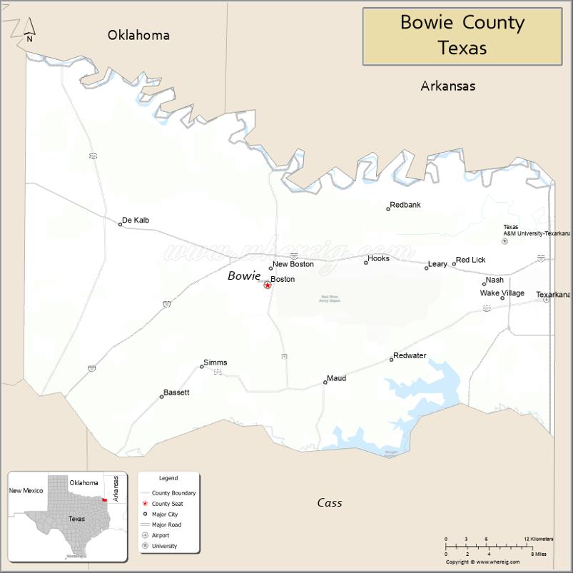
About Bowie County Map, Texas: The map showing the county boundary, county seat, major cities, highways, water bodies and neighbouring counties.
Related Texas Maps
Map of Bowie County, Texas
Bowie County is a county located in the U.S. state of Texas. It's county seat is New Boston. As per 2020 census, the population of Bowie County is 92581 people and population density is square miles. According to the United States Census Bureau, the county has a total area of 888 sq mi (2,300 km2). Bowie County was established on 1840.
Facts about Bowie County, Texas
| Country | United States |
| State | Texas |
| Region | Northeast Texas |
| County Seat | Boston (New Boston serves as the principal city for administration) |
| Named After | James Bowie |
| Established | 1840 |
| Organized | 1841 |
| Coordinates | 33.4418° N, 94.4171° W |
| Total Area | 923 sq mi |
| Land Area | 885 sq mi |
| Water Area | 38 sq mi |
| Population (2020) | 92,893 |
| Population Rank | Major county in Northeast Texas |
| Major Cities | Texarkana, New Boston |
| Main Industries | Manufacturing, Retail, Agriculture, Transportation |
| Major Airport | Texarkana Regional Airport |
| Time Zone | Central Time (UTC−06:00) |
| Known For | Texarkana (city split with Arkansas), Red River, Historic rail and trade center |
| Website | https://www.co.bowie.tx.us |
Top Attractions in Bowie County, Texas
- Perot Theatre (Texarkana) – Restored historic theater hosting concerts and shows.
- Texarkana Regional Arts Center – Local art exhibits and cultural programs.
- Texarkana Museum of Regional History – Exhibits on early settlement and regional heritage.
- Four States Auto Museum – Classic cars and automotive memorabilia.
- Spring Lake Park – Large park with walking trails and picnic areas.
- Bringle Lake Park – Lakeside trails, fishing spots, and disc golf.
- Downtown Texarkana – Iconic state line photo spot and historic district.
- Draughon–Moore Ace of Clubs House – Unique 1885 home shaped like a club symbol.
- Orr Lake Park – Quiet outdoor area for fishing and bird-watching.
- Holiday Springs Water Park – Seasonal water park with slides and pools.
Cities and Towns in Bowie County, Texas
| Place | Type | Population (Census 2020) | Latitude & Longitude |
|---|---|---|---|
| New Boston (county seat - courthouse location) | City | 4612 | 33.4596°N, 94.4155°W |
| Texarkana | City | 36593 | 33.4251°N, 94.0477°W |
| Wake Village | City | 5492 | 33.4265°N, 94.1063°W |
| Nash | City | 3814 | 33.4429°N, 94.1302°W |
| Hooks | City | 2769 | 33.4668°N, 94.1835°W |
| De Kalb | City | 1699 | 33.5084°N, 94.6169°W |
| Leary | City | 433 | 33.4682°N, 94.2424°W |
| Redwater | City | 853 | 33.3587°N, 94.2549°W |
| Maud | City | 1056 | 33.3332°N, 94.3441°W |
| Red Lick | Census Designated Place (CDP) | 1008 | 33.4658°N, 94.0814°W |
| Simms | Unincorporated Community | N/A | 33.6204°N, 94.5380°W |
| Malta | Unincorporated Community | N/A | 33.5010°N, 94.7124°W |
| Boston | Unincorporated Community | N/A | 33.4440°N, 94.4238°W |
| Dalby Springs | Unincorporated Community | N/A | 33.6328°N, 94.6876°W |
What are Major Roads and Highways in Bowie County
Major highways connect the county to nearby regions and cities.
- Interstate 30 - west toward Dallas and east toward Little Rock, Arkansas
- Interstate 369 (future corridor) - serves the Texarkana area
- U.S. Highway 59 - southwest toward Atlanta and northeast toward Texarkana
- U.S. Highway 67 - west toward Mount Pleasant and east toward Arkansas
- U.S. Highway 71 - north toward De Queen, Arkansas and south toward Louisiana
- U.S. Highway 82 - east-west route through New Boston and De Kalb
- U.S. Highway 259 - south toward Longview and north toward Oklahoma
- Texas State Highway 8 - connects New Boston, Maud, and New Diana region
- Texas State Highway 98 - serves the northern Texarkana area
What are Neighboring Counties of Bowie County
- Little River County, Arkansas (north)
- Miller County, Arkansas (northeast)
- Cass County (west)
- Morris County (southwest)
- Red River County (south)
- Titus County (southwest corner)
Distance from Bowie County to Nearby Cities
The following distances are measured by road (driving).
- New Boston to Texarkana (Bowie County), Texas - 22 mi (35 km)
- New Boston to De Kalb (Bowie County), Texas - 18 mi (29 km)
- New Boston to Atlanta (Cass County), Texas - 24 mi (39 km)
- New Boston to Mount Pleasant (Titus County), Texas - 48 mi (77 km)
- New Boston to Clarksville (Red River County), Texas - 37 mi (60 km)
- New Boston to Daingerfield (Morris County), Texas - 42 mi (68 km)
- New Boston to Ashdown (Little River County), Arkansas - 28 mi (45 km)
- New Boston to Texarkana, Arkansas - 25 mi (40 km)
- New Boston to Longview (Gregg County), Texas - 92 mi (148 km)
- New Boston to Tyler (Smith County), Texas - 115 mi (185 km)
- New Boston to Shreveport, Louisiana - 95 mi (153 km)
- New Boston to Paris (Lamar County), Texas - 83 mi (134 km)
- New Boston to Dallas (Dallas County), Texas - 173 mi (278 km)
- New Boston to Little Rock, Arkansas - 145 mi (233 km)
- New Boston to Houston (Harris County), Texas - 286 mi (460 km)
Waterbodies in Bowie County
Red River, Sulphur River, Wright Patman Lake, Lake Wright Patman, McKinney Bayou, Anderson Creek, Days Creek, Elliott Creek, Kelly Bayou, Pecan Bayou, Black Cypress Bayou watershed, White Oak Creek watershed, Red River floodplain wetlands, springs, reservoirs, oxbow lakes, and seasonal streams
Best Golf Courses in Bowie County, Texas
| Golf Course | Location | Latitude & Longitude |
|---|---|---|
| Texarkana Country Club | Texarkana | 33.4718°N, 94.0908°W |
| Northridge Country Club | Texarkana | 33.5004°N, 94.0745°W |
| New Boston Country Club | New Boston | 33.4659°N, 94.4351°W |
Colleges and Universities in Bowie County, Texas
| Institution Name | Type | Level | Notable For |
|---|---|---|---|
| Texarkana College | Public | Community College | Primary community college serving the county |
| Texas A&M University-Texarkana | Public | University | Four-year and graduate degree programs |
| University of Arkansas Hope-Texarkana | Public | Community College | Technical and workforce education |
References
- U.S. Census Bureau - Bowie County QuickFacts
- Official Bowie County Website
- Texas State Historical Association - Bowie County
- Texas A&M University-Texarkana
- Texarkana College
- Anderson County Map
- Andrews County Map
- Angelina County Map
- Aransas County Map
- Archer County Map
- Armstrong County Map
- Atascosa County Map
- Austin County Map
- Bailey County Map
- Bandera County Map
- Bastrop County Map
- Baylor County Map
- Bee County Map
- Bell County Map
- Bexar County Map
- Blanco County Map
- Borden County Map
- Bosque County Map
- Bowie County Map
- Brazoria County Map
- Brazos County Map
- Brewster County Map
- Briscoe County Map
- Brooks County Map
- Brown County Map
- Burleson County Map
- Burnet County Map
- Caldwell County Map
- Calhoun County Map
- Callahan County Map
- Cameron County Map
- Camp County Map
- Carson County Map
- Cass County Map
- Castro County Map
- Chambers County Map
- Cherokee County Map
- Childress County Map
- Clay County Map
- Cochran County Map
- Coke County Map
- Coleman County Map
- Collin County Map
- Collingsworth County Map
- Colorado County Map
- Comal County Map
- Comanche County Map
- Concho County Map
- Cooke County Map
- Coryell County Map
- Cottle County Map
- Crane County Map
- Crockett County Map
- Crosby County Map
- Culberson County Map
- Dallam County Map
- Dallas County Map
- Dawson County Map
- Deaf Smith County Map
- Delta County Map
- Denton County Map
- DeWitt County Map
- Dickens County Map
- Dimmit County Map
- Donley County Map
- Duval County Map
- Eastland County Map
- Ector County Map
- Edwards County Map
- Ellis County Map
- El Paso County Map
- Erath County Map
- Falls County Map
- Fannin County Map
- Fayette County Map
- Fisher County Map
- Floyd County Map
- Foard County Map
- Fort Bend County Map
- Franklin County Map
- Freestone County Map
- Frio County Map
- Gaines County Map
- Galveston County Map
- Garza County Map
- Gillespie County Map
- Glasscock County Map
- Goliad County Map
- Gonzales County Map
- Gray County Map
- Grayson County Map
- Gregg County Map
- Grimes County Map
- Guadalupe County Map
- Hale County Map
- Hall County Map
- Hamilton County Map
- Hansford County Map
- Hardeman County Map
- Hardin County Map
- Harris County Map
- Harrison County Map
- Hartley County Map
- Haskell County Map
- Hays County Map
- Hemphill County Map
- Henderson County Map
- Hidalgo County Map
- Hill County Map
- Hockley County Map
- Hood County Map
- Hopkins County Map
- Houston County Map
- Howard County Map
- Hudspeth County Map
- Hunt County Map
- Hutchinson County Map
- Irion County Map
- Jack County Map
- Jackson County Map
- Jasper County Map
- Jeff Davis County Map
- Jefferson County Map
- Jim Hogg County Map
- Jim Wells County Map
- Johnson County Map
- Jones County Map
- Karnes County Map
- Kaufman County Map
- Kendall County Map
- Kenedy County Map
- Kent County Map
- Kerr County Map
- Kimble County Map
- King County Map
- Kinney County Map
- Kleberg County Map
- Knox County Map
- Lamar County Map
- Lamb County Map
- Lampasas County Map
- La Salle County Map
- Lavaca County Map
- Lee County Map
- Leon County Map
- Liberty County Map
- Limestone County Map
- Lipscomb County Map
- Live Oak County Map
- Llano County Map
- Loving County Map
- Lubbock County Map
- Lynn County Map
- McCulloch County Map
- McLennan County Map
- McMullen County Map
- Madison County Map
- Marion County Map
- Martin County Map
- Mason County Map
- Matagorda County Map
- Maverick County Map
- Medina County Map
- Menard County Map
- Midland County Map
- Milam County Map
- Mills County Map
- Mitchell County Map
- Montague County Map
- Montgomery County Map
- Moore County Map
- Morris County Map
- Motley County Map
- Nacogdoches County Map
- Navarro County Map
- Newton County Map
- Nolan County Map
- Nueces County Map
- Ochiltree County Map
- Oldham County Map
- Orange County Map
- Palo Pinto County Map
- Panola County Map
- Parker County Map
- Parmer County Map
- Pecos County Map
- Polk County Map
- Potter County Map
- Presidio County Map
- Rains County Map
- Randall County Map
- Reagan County Map
- Real County Map
- Red River County Map
- Reeves County Map
- Refugio County Map
- Roberts County Map
- Robertson County Map
- Rockwall County Map
- Runnels County Map
- Rusk County Map
- Sabine County Map
- San Augustine County Map
- San Jacinto County Map
- San Patricio County Map
- San Saba County Map
- Schleicher County Map
- Scurry County Map
- Shackelford County Map
- Shelby County Map
- Sherman County Map
- Smith County Map
- Somervell County Map
- Starr County Map
- Stephens County Map
- Sterling County Map
- Stonewall County Map
- Sutton County Map
- Swisher County Map
- Tarrant County Map
- Taylor County Map
- Terrell County Map
- Terry County Map
- Throckmorton County Map
- Titus County Map
- Tom Green County Map
- Travis County Map
- Trinity County Map
- Tyler County Map
- Upshur County Map
- Upton County Map
- Uvalde County Map
- Val Verde County Map
- Van Zandt County Map
- Victoria County Map
- Walker County Map
- Waller County Map
- Ward County Map
- Washington County Map
- Webb County Map
- Wharton County Map
- Wheeler County Map
- Wichita County Map
- Wilbarger County Map
- Willacy County Map
- Williamson County Map
- Wilson County Map
- Winkler County Map
- Wise County Map
- Wood County Map
- Yoakum County Map
- Young County Map
- Zapata County Map
- Zavala County Map
- Alabama Counties
- Alaska boroughs
- Arizona Counties
- Arkansas Counties
- California County Map
- Colorado Counties
- Connecticut Counties
- Delaware Counties
- Florida County Map
- Georgia County Map
- Hawaii Counties
- Idaho Counties
- Illinois Counties
- Indiana Counties
- Iowa Counties
- Kansas Counties
- Kentucky Counties
- Louisiana Counties
- Maine Counties
- Maryland Counties
- Massachusetts Counties
- Michigan County Map
- Minnesota Counties
- Mississippi Counties
- Missouri Counties
- Montana Counties
- Nebraska Counties
- Nevada Counties
- New York Counties
- New Hampshire Counties
- New Jersey Counties
- New Mexico Counties
- North Carolina Counties
- North Dakota Counties
- Ohio County Map
- Oklahoma Counties
- Oregon Counties
- Pennsylvania Counties
- Rhode Island Counties
- South Carolina Counties
- South Dakota Counties
- Map of Tennessee
- Texas County Map
- Utah Counties
- Vermont Counties
- Virginia Counties
- Washington Counties
- West Virginia Counties
- Wisconsin Counties
- Wyoming Counties
References
- ^ QuickFacts: Bowie County, Texas - United States Census Bureau
- ^ United States Census Bureau - Population and Housing Data
- ^ TIGER/Line Shapefiles - United States Census Bureau
- ^ United States Geological Survey (USGS)
- ^ National Geodetic Survey (NGS), NOAA
- ^ Official Website of Bowie County, Texas
- ^ Texas Department of Transportation (TxDOT)