
Seminole is a city in the South Plains of West Texas and the county seat of Gaines County. Located about 40 miles west of Andrews and 70 miles southwest of Lubbock, the city sits in a broad agricultural and oil-producing region. Seminole is known for cotton farming, petroleum production, and its role as a regional center for the surrounding Permian Basin communities.
Location Map of Seminole, Gaines County, Texas
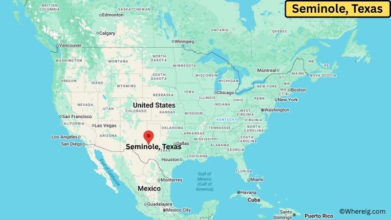
About Map: The map shows the location of Seminole in Gaines County, in the U.S. state of Texas.
Seminole Map, Texas
About Seminole Map: The Google Map highlights the location of Seminole in Gaines County, Texas. Use the zoom, satellite, and street-view options to explore the city's neighborhoods, roads, and nearby places.
Where is Seminole Located?
Seminole is a city located in Gaines County, Texas, the United States. It lies in the western South Plains near the New Mexico border and within the broader Permian Basin region. Seminole is about 40 miles west of Andrews, 45 miles south of Hobbs, New Mexico, and roughly 70 miles southwest of Lubbock. The city is located at 32.7182° North latitude and 102.6447° West longitude. The 2020 Census recorded 7,442 residents. Seminole covers about 7.2 square miles (18.6 square kilometers), with nearly all of its area consisting of land. Agriculture and oil production are major parts of the local economy, with cotton being an important crop in the surrounding area. Gaines County Golf Course and the Gaines County Museum are notable local attractions. A unique feature of Seminole is its location in one of the most important oil-producing regions of West Texas.
Most Viewed US Maps
| USA Sttae Map | USA Region Map | USA Road Map |
| USA County Map | Where is USA in World Map? | US ZIP Code Map |
| USA Time Zones Map | US State and Capitals Map | USA Physical Map |
Find 4,400+ U.S. Cities by State - Explore Their Locations and Get Detailed Information
Seminole City Facts
| Fact | Details |
|---|---|
| City | Seminole |
| State | Texas |
| County | Gaines County |
| Country | United States |
| Region | South Plains, West Texas |
| Incorporated | 1914 |
| Founded | 1906 |
| Total Area | 7.2 sq mi (18.6 sq km) |
| Land Area | 7.2 sq mi (18.6 sq km) |
| Water Area | 0.0 sq mi (0.0 sq km) |
| Elevation | About 3,300 ft (1,006 m) |
| Population (2023 estimate) | About 7,400 |
| Population (2020 Census) | 7,442 |
| Population Density | About 1,034 people per sq mi |
| Time Zone | Central Time (CST/CDT) |
| ZIP Codes | 79360 |
| Area Code | 432 |
| Major Highways | U.S. Highway 180, U.S. Highway 385, Texas State Highway 214 |
| Public Transit | Local and regional community transportation services |
| Major Attractions | Gaines County Museum, Gaines County Golf Course, Wigwam Stadium, Seminole City Park |
| Official Website | https://www.seminoletx.gov/ |
Distance from Seminole, TX to Nearby Cities
- Denver City, TX – 25 miles (40 km)
- Hobbs, NM – 45 miles (72 km)
- Andrews, TX – 40 miles (64 km)
- Seagraves, TX – 18 miles (29 km)
- Loop, TX – 20 miles (32 km)
- Brownfield, TX – 45 miles (72 km)
- Plains, TX – 35 miles (56 km)
- Lovington, NM – 60 miles (97 km)
- Levelland, TX – 65 miles (105 km)
- Lamesa, TX – 55 miles (89 km)
- Odessa, TX – 65 miles (105 km)
- Midland, TX – 75 miles (121 km)
- Lubbock, TX – 70 miles (113 km)
- Big Spring, TX – 85 miles (137 km)
- Monahans, TX – 85 miles (137 km)
- Plainview, TX – 100 miles (161 km)
- Clovis, NM – 115 miles (185 km)
- San Angelo, TX – 155 miles (249 km)
Top Attractions in Seminole, Texas
- Gaines County Museum – A local museum preserving artifacts, photographs, documents, and stories from Gaines County and the surrounding West Texas region.
- Gaines County Golf Course – A local recreation facility offering a golf course surrounded by the open landscapes of the South Plains.
- Seminole City Park – A community park with green space, playgrounds, sports facilities, and areas for outdoor recreation.
- Wigwam Stadium – A local sports venue used for high school athletics and community events.
- Seminole Heritage Park – A community space reflecting the history and heritage of Seminole and Gaines County.
- Permian Basin – The large oil-producing region surrounding Seminole, known for petroleum production and the energy industry.
- Lea County Museum – A regional museum in nearby Lovington, New Mexico, featuring exhibits on local history, ranching, transportation, and the oil industry.
- McDonald Observatory – A major astronomical research facility in the Davis Mountains, located several hours southwest of Seminole.
- Monahans Sandhills State Park – A distinctive West Texas park featuring large wind-shaped sand dunes, hiking, camping, and sand-based recreation.
Airports Near Seminole, Texas
- Lea County Regional Airport (HOB) – 45 miles
- Andrews County Airport (E11) – 40 miles
- Midland International Air and Space Port (MAF) – 75 miles
- Lubbock Preston Smith International Airport (LBB) – 75 miles
Sources:
Population and area data sourced from the United States Census Bureau (2020 Census). General city information referenced from the official Seminole city website and local government records.
Texas Maps and Info
- Where is Abilene
- Where is Allen
- Where is Alvin
- Where is Amarillo
- Where is Atascocita
- Where is Balch Springs
- Where is Baytown
- Where is Beaumont
- Where is Bedford
- Where is Belton
- Where is Benbrook
- Where is Big Spring
- Where is Brownsville
- Where is Brushy Creek
- Where is Bryan
- Where is Burleson
- Where is Canyon Lake
- Where is Carrollton
- Where is Cedar Hill
- Where is Cedar Park
- Where is Channelview
- Where is Cibolo
- Where is Cleburne
- Where is Cloverleaf
- Where is College Station
- Where is Colleyville
- Where is Conroe
- Where is Converse
- Where is Coppell
- Where is Copperas Cove
- Where is Corinth
- Where is Corsicana
- Where is Deer Park
- Where is Del Rio
- Where is Denison
- Where is Denton
- Where is DeSoto
- Where is Duncanville
- Where is Eagle Pass
- Where is Edinburg
- Where is Euless
- Where is Farmers Branch
- Where is Flower Mound
- Where is Forney
- Where is Fort Hood
- Where is Friendswood
- Where is Frisco
- Where is Fulshear
- Where is Galveston
- Where is Georgetown
- Where is Grand Prairie
- Where is Grapevine
- Where is Greenville
- Where is Haltom City
- Where is Harker Heights
- Where is Harlingen
- Where is Horizon City
- Where is Huntsville
- Where is Hurst
- Where is Hutto
- Where is Katy
- Where is Keller
- Where is Kerrville
- Where is Killeen
- Where is Kingsville
- Where is Kyle
- Where is La Porte
- Where is Lake Jackson
- Where is Lakeway
- Where is Lancaster
- Where is League City
- Where is Leander
- Where is Lewisville
- Where is Little Elm
- Where is Longview
- Where is Lufkin
- Where is Mansfield
- Where is Marshall
- Where is McAllen
- Where is McKinney
- Where is Mesquite
- Where is Midland
- Where is Midlothian
- Where is Mission
- Where is Mission Bend
- Where is Missouri City
- Where is Murphy
- Where is Nacogdoches
- Where is New Braunfels
- Where is North Richland Hills
- Where is Odessa
- Where is Paris
- Where is Pasadena
- Where is Pearland
- Where is Pecan Grove
- Where is Pflugerville
- Where is Pharr
- Where is Plano
- Where is Port Arthur
- Where is Prosper
- Where is Richardson
- Where is Rockwall
- Where is Rosenberg
- Where is Round Rock
- Where is Rowlett
- Where is Sachse
- Where is Saginaw
- Where is San Angelo
- Where is San Antonio
- Where is San Benito
- Where is San Juan
- Where is San Marcos
- Where is Schertz
- Where is Seguin
- Where is Sherman
- Where is Socorro
- Where is Southlake
- Where is Spring
- Where is Stephenville
- Where is Sugar Land
- Where is Temple
- Where is Texarkana
- Where is Texas City
- Where is The Colony
- Where is The Woodlands
- Where is Timberwood Park
- Where is Tyler
- Where is University Park
- Where is Victoria
- Where is Waco
- Where is Watauga
- Where is Waxahachie
- Where is Weatherford
- Where is Weslaco
- Where is West Odessa
- Where is Wichita Falls
- Where is Wylie