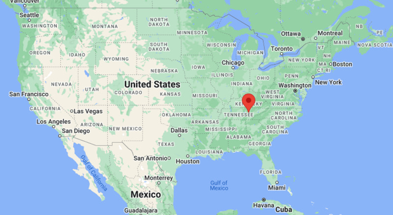
Where is Crossville Located? - Crossville is a city located in the Cumberland County of Tennessee, United States. Crossville lies between 39.9837084 Degrees North latitudes and 76.8224701 Degrees West longitudes.
Location Map of Crossville, Tennessee
Crossville Map, Tennessee, USA
Where is Crossville Located?
Crossville is a city located in the Cumberland County of Tennessee, United States. Crossville lies between 39.9837084 Degrees North latitudes and 76.8224701 Degrees West longitudes. According to 2020 U.S.census, the population of Crossville city is 12071 people and the city has a total area of 20.4 sq mi. The city has numerous parks and recreational facilities.
Most Viewed US Maps
Crossville, Tennessee Quick Facts
Field Value
City Crossville County Cumberland County State Tennessee State Capital Nashville US Region Southeastern United States Latitude 35.9489°N Longitude 85.0269°W Elevation 1,880 ft (573 m) Land Area ~12.6 sq mi Water Area ~0.1 sq mi Total Area ~12.7 sq mi Population ~11,800 (2020 Census) Population Density ~930 per sq mi ZIP Codes 38555, 38571 Area Code 931 Time Zone (Standard) Eastern Standard Time (EST) UTC -5 Time Zone (DST) Eastern Daylight Time (EDT) UTC -4 Currency US Dollar (USD) FIPS Code 47-18280 Congressional District 6th District
Nearby Cities to Crossville, Tennessee
Cookeville, Tennessee — 35 mi North
Knoxville, Tennessee — 80 mi East
Chattanooga, Tennessee — 85 mi South
Nashville, Tennessee — 100 mi West
Oak Ridge, Tennessee — 55 mi Northeast
Sparta, Tennessee — 45 mi Northwest
Dayton, Tennessee — 75 mi Southwest
Jamestown, Tennessee — 30 mi North
Rockwood, Tennessee — 25 mi South
Monterey, Tennessee — 40 mi East
Crossville, Tennessee Climate and Weather Overview
Month Avg High (°F) Avg Low (°F) Avg Rainfall (in)
January 46 27 4.8 April 67 44 4.6 July 86 66 5.0 October 70 48 3.7 Annual 66 46 54.0
Climate Attribute Value
Climate Classification (Köppen) Humid Subtropical (Cfa) / Plateau-influenced Annual Rainfall ~50–55 inches Annual Snowfall ~5–10 inches Annual Sunshine Days ~200 days Tornado Risk Low to Moderate
Driving Distances from Crossville, Tennessee
City State Distance (mi) Approx. Drive Time
Cookeville TN 35 40 min Knoxville TN 80 1 hr 20 min Chattanooga TN 85 1 hr 25 min Nashville TN 100 1 hr 45 min Oak Ridge TN 55 1 hr Sparta TN 45 50 min Rockwood TN 25 30 min Dayton TN 75 1 hr 20 min Morristown TN 120 2 hr 10 min Huntsville AL 120 2 hr 15 min
Transportation and Connectivity in Crossville, Tennessee
Mode Details
Airport McGhee Tyson Airport (TYS), Nashville International Airport (BNA) Port No direct port access (inland city) Major Highways I-40, US-70, US-127 Rail/Amtrak No direct Amtrak service (nearest in major Tennessee cities) Local Transit Limited local and regional county transportation services
I-40 — major east-west interstate connecting Crossville with Knoxville and Nashville
US-127 — north-south route linking Kentucky and central Tennessee through Crossville
US-70 — regional corridor connecting nearby Plateau communities
Key Landmarks and Places to Visit in Crossville, Tennessee
Landmark Name Type
Cumberland Mountain State Park State Park Ozone Falls State Natural Area Waterfall / Nature Area Military Memorial Museum Museum Homesteads Tower Museum Historic Museum Deer Creek Golf Club Golf Course Bear Trace at Cumberland Mountain Golf Course Stonehaus Winery Winery / Attraction Woodmere Mall Area (Crossville) Shopping Area
Places to Visit in Crossville, Tennessee
Landmark Name Type
Downtown Crossville Historic District Historic Downtown Black Mountain Recreation Area Nature Area Lake Tansi Village Area Recreation / Lake Community Cumberland County Playhouse Theatre / Arts Venue Obed Wild & Scenic River (nearby) National River Area Virgin Falls State Natural Area (nearby) Hiking Area Catoosa Wildlife Management Area Wildlife Area Fairfield Glade Resort Area Resort Community
Colleges and Universities in Crossville, Tennessee
Institution Name Type Level Notable For
Tennessee College of Applied Technology (Crossville campus) Public Technical College Career & trade programs Roane State Community College (nearby campuses) Public Community College Associate degrees & transfers University of Tennessee (Knoxville - regional) Public University Research & engineering
Waterbodies in Crossville, Tennessee
Dale Hollow Lake (regional), Lake Tansi, Lake Holiday, Obed River, Caney Fork River
Golf Courses in Crossville, Tennessee
Bear Trace at Cumberland Mountain, Fairfield Glade Golf Courses, Deer Creek Golf Club, Stonehenge Golf Club, Druid Hills Golf Club
Crossville, Tennessee - Key Historical Facts
Crossville developed as a transportation and trading point along early Cumberland Plateau routes.
The city became the county seat of Cumberland County in the 19th century.
Railroad expansion helped strengthen its role as a regional service center.
During the New Deal era, nearby Cumberland Mountain State Park was developed by the CCC.
Crossville is known as the “Golf Capital of Tennessee” due to its large number of courses.
Today it serves as a hub for tourism, retirement communities, and outdoor recreation.
References
Tennessee Maps & Info
Location Map of Tennessee Cities
Popular US Cities
About USA
US Counties
World Countries
World Cup 2026