
Where is Farragut Located? - Farragut is a city located in the Knox County of Tennessee, United States. Farragut lies between 40.1012856 Degrees North latitudes and 75.3835525 Degrees West longitudes.
Location Map of Farragut, Tennessee
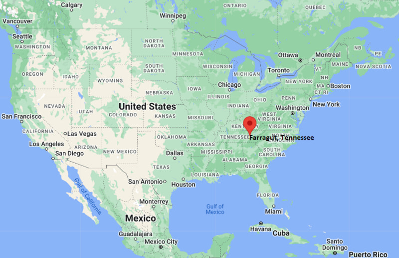
Farragut Map, Tennessee, USA
Where is Farragut?: The Google Map showing the location of Farragut in the U.S. state of Tennessee.
Where is Farragut Located?
Farragut is a city located in the Knox County of Tennessee, United States. Farragut lies between 40.1012856 Degrees North latitudes and 75.3835525 Degrees West longitudes. According to 2020 U.S.census, the population of Farragut city is 23506 people and the city has a total area of 15.97 sq mi. The city has numerous parks and recreational facilities.
Most Viewed US Maps
| USA Sttae Map | USA Region Map | USA Road Map |
| USA County Map | Where is USA in World Map? | US ZIP Code Map |
| USA Time Zones Map | US State and Capitals Map | USA Physical Map |
Find 4,400+ U.S. Cities by State - Explore Their Locations and Get Detailed Information
Farragut, Tennessee Quick Facts
| Property | Information |
|---|---|
| City | Farragut |
| County | Knox County |
| State | Tennessee |
| State Capital | Nashville |
| US Region | Southern United States |
| Latitude | 35.8840° N |
| Longitude | 84.1533° W |
| Elevation | 886 ft (270 m) |
| Land Area | 16.29 sq mi |
| Water Area | 0.12 sq mi |
| Total Area | 16.41 sq mi |
| Population (latest Census year) | 23,506 (2020 Census) |
| Population Density | 1,443 per sq mi |
| ZIP Codes | 37922, 37934 |
| Area Code | 865 |
| Time Zone Standard | Eastern Standard Time (EST, UTC−5) |
| Time Zone Daylight | Eastern Daylight Time (EDT, UTC−4) |
| Currency | US Dollar (USD) |
| FIPS Code | 47-25440 |
| Congressional District | 2nd Congressional District |
Nearby Cities to Farragut, Tennessee
- Knoxville, Tennessee — 16 mi East
- Lenoir City, Tennessee — 9 mi Southwest
- Oak Ridge, Tennessee — 16 mi Northwest
- Louisville, Tennessee — 12 mi South
- Maryville, Tennessee — 20 mi South
- Alcoa, Tennessee — 18 mi South
- Kingston, Tennessee — 27 mi West
- Clinton, Tennessee — 23 mi North
- Sevierville, Tennessee — 41 mi East
- Loudon, Tennessee — 20 mi Southwest
Driving Distances from Farragut, Tennessee
| City | State | Distance (mi) | Approx. Drive Time |
|---|---|---|---|
| Lenoir City | Tennessee | 9 | 12 min |
| Knoxville | Tennessee | 16 | 22 min |
| Oak Ridge | Tennessee | 16 | 20 min |
| Louisville | Tennessee | 12 | 18 min |
| Maryville | Tennessee | 20 | 28 min |
| Alcoa | Tennessee | 18 | 25 min |
| Clinton | Tennessee | 23 | 30 min |
| Kingston | Tennessee | 27 | 32 min |
| Sevierville | Tennessee | 41 | 50 min |
| Nashville | Tennessee | 178 | 2 hr 50 min |
Transportation and Connectivity in Farragut, Tennessee
| Category | Information |
|---|---|
| Airport Name | McGhee Tyson Airport |
| IATA Code | TYS |
| Port | Not applicable |
| Major Highways | Interstate 40, Interstate 75, U.S. Route 11, State Route 332 (Concord Road), Kingston Pike |
| Train/Amtrak Service | No Amtrak service; nearest passenger rail station is in Atlanta, Georgia |
| Local Bus/Transit Service | Knoxville Area Transit (KAT) serves nearby Knoxville; local commuter services available |
- Interstate 40 - Major east-west interstate connecting Farragut with Knoxville, Nashville and eastern Tennessee.
- Interstate 75 - North-south interstate providing access to Kentucky, Chattanooga and Florida.
- U.S. Route 11 (Kingston Pike) - Historic commercial corridor through Farragut linking Knoxville and Lenoir City.
- State Route 332 (Concord Road) - Connects residential neighborhoods with parks, schools and Fort Loudoun Lake.
- Campbell Station Road - Important local route serving shopping areas, businesses and residential developments.
What are top Places to Visit in Farragut, Tennessee
| Landmark Name | Type |
|---|---|
| Farragut Museum | Museum |
| Anchor Park | Park |
| McFee Park | Community Park |
| Campbell Station Park | Historic Park |
| Turkey Creek Shopping Center | Shopping District |
| Concord Park | Lakeside Park |
| Fort Loudoun Lake | Recreation Area |
| Ijams Nature Center | Nature Center |
| Knoxville Botanical Garden and Arboretum | Botanical Garden |
| World's Fair Park | Urban Park |
Colleges and Universities in Farragut, Tennessee
| Institution Name | Type | Level | Notable For |
|---|---|---|---|
| University of Tennessee, Knoxville | Public | University | Flagship research university |
| Pellissippi State Community College | Public | Community College | Transfer and workforce education |
| South College | Private | University | Health sciences and professional programs |
| Knox County Schools | Public | K–12 District | Comprehensive public education |
Waterbodies in Farragut, Tennessee
Fort Loudoun Lake, Tennessee River, Little Turkey Creek, Turkey Creek, Beaver Creek, Concord Lake, Melton Hill Lake, Clinch River
Golf Courses in Farragut, Tennessee
Fox Den Country Club, Willow Creek Golf Club, Avalon Golf & Country Club, Dead Horse Lake Golf Course, Egwani Farms Golf Course, Gettysvue Polo, Golf and Country Club
Farragut, Tennessee — Key Historical Facts
- Farragut was incorporated in 1980 and was named in honor of Admiral David Glasgow Farragut, the first admiral of the United States Navy, who was born nearby.
- The community developed around Campbell's Station, an important frontier settlement and stagecoach stop during the late eighteenth and early nineteenth centuries.
- Kingston Pike, which passes through Farragut, served as a major transportation route connecting Knoxville with western Tennessee long before the Interstate era.
- Rapid suburban growth during the late twentieth century transformed Farragut into one of the Knoxville area's most desirable residential communities.
- Today, Farragut is recognized for its excellent schools, extensive parks, family-friendly neighborhoods, and convenient access to Knoxville and Fort Loudoun Lake.
References
Tennessee Maps & Info
- Where is Athens
- Where is Bartlett
- Where is Brentwood
- Where is Bristol
- Where is Chattanooga
- Where is Clarksville
- Where is Collierville
- Where is Columbia
- Where is Cookeville
- Where is Crossville
- Where is Dickson
- Where is Dyersburg
- Where is East Ridge
- Where is Elizabethton
- Where is Farragut
- Where is Franklin
- Where is Gallatin
- Where is Germantown
- Where is Goodlettsville
- Where is Greeneville
- Where is Hartsville
- Where is Hendersonville
- Where is Jackson
- Where is Johnson City
- Where is Kingsport
- Where is Knoxville
- Where is La Vergne
- Where is Lakeland
- Where is Lebanon
- Where is Lewisburg
- Where is Manchester
- Where is Maryville
- Where is McMinnville
- Where is Morristown
- Where is Mount Juliet
- Where is Murfreesboro
- Where is Nolensville
- Where is Oak Ridge
- Where is Sevierville
- Where is Seymour
- Where is Shelbyville
- Where is Smyrna
- Where is Soddy-Daisy
- Where is Spring Hill
- Where is Tullahoma
- Where is White House