
Where is Tullahoma Located? - Tullahoma is a city located in the Coffee County, Franklin County of Tennessee, United States. Tullahoma lies between 39.9375911 Degrees North latitudes and 77.6611022 Degrees West longitudes.
Location Map of Tullahoma, Tennessee
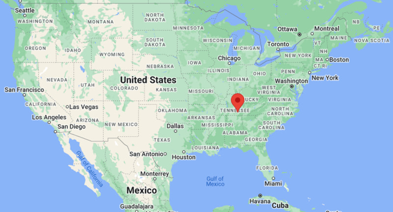
Tullahoma Map, Tennessee, USA
Where is Tullahoma?: The Google Map showing the location of Tullahoma in the U.S. state of Tennessee.
Where is Tullahoma Located?
Tullahoma is a city located in the Coffee County, Franklin County of Tennessee, United States. Tullahoma lies between 39.9375911 Degrees North latitudes and 77.6611022 Degrees West longitudes. According to 2020 U.S.census, the population of Tullahoma city is 20339 people and the city has a total area of 23.44 sq mi. The city has numerous parks and recreational facilities.
Most Viewed US Maps
| USA Sttae Map | USA Region Map | USA Road Map |
| USA County Map | Where is USA in World Map? | US ZIP Code Map |
| USA Time Zones Map | US State and Capitals Map | USA Physical Map |
Find 4,400+ U.S. Cities by State - Explore Their Locations and Get Detailed Information
Tullahoma, Tennessee Quick Facts
| Attribute | Details |
|---|---|
| City | Tullahoma |
| County | Coffee County and Franklin County |
| State | Tennessee |
| State Capital | Nashville |
| US Region | Southern United States |
| Latitude | 35.3620° N |
| Longitude | 86.2094° W |
| Elevation | Approximately 1,080 ft (329 m) |
| Land Area | 23.2 sq mi |
| Water Area | 0.1 sq mi |
| Total Area | 23.3 sq mi |
| Population (2020 Census) | 20,339 |
| Population Density | Approximately 877 per sq mi |
| ZIP Codes | 37388, 37389 |
| Area Code | 931 |
| Time Zone Standard | Central Standard Time (CST), UTC−6 |
| Time Zone Daylight | Central Daylight Time (CDT), UTC−5 |
| Currency | United States Dollar (USD) |
| FIPS Code | 47-75400 |
| Community Type | City |
Transportation and Connectivity in Tullahoma, Tennessee
| Transportation | Details |
|---|---|
| Airport Name | Nashville International Airport |
| IATA Code | BNA |
| Regional Airport | Tullahoma Regional Airport (William Northern Field) |
| Port | Port of Nashville |
| Major Highways | US Highway 41A, US Highway 231, Tennessee State Route 55 |
| Train/Amtrak Service | Amtrak service available in nearby communities |
| Local Transit Service | Local and regional transportation services |
- US Highway 41A — Major route connecting Tullahoma with Winchester, Manchester, and nearby communities.
- US Highway 231 — Provides regional connections toward Murfreesboro and southern Middle Tennessee.
- Tennessee State Route 55 — Connects Tullahoma with surrounding Coffee County areas.
Top Places to Visit in Tullahoma, Tennessee
| Landmark Name | Type |
|---|---|
| Jack Daniel's Distillery | Historic Distillery |
| Beckwith Park | Public Park |
| Old Stone Fort State Archaeological Park | Historic State Park |
| South Jackson Civic Center | Community and Event Center |
| Tullahoma Fine Arts Center | Arts Center |
| Short Springs Natural Area | Nature Preserve |
| Rutledge Falls | Waterfall Attraction |
| Staggerwing Museum | Aviation Museum |
| Arnold Engineering Development Complex | Aerospace Research Facility |
| Motlow State Community College Campus | Educational Landmark |
Driving Distances from Tullahoma, Tennessee to Nearby Cities
| City | State | Distance (mi) | Approx. Drive Time |
|---|---|---|---|
| Manchester | Tennessee | 15 mi | 20 minutes |
| Winchester | Tennessee | 18 mi | 25 minutes |
| Murfreesboro | Tennessee | 55 mi | 1 hour |
| Chattanooga | Tennessee | 80 mi | 1 hour 30 minutes |
| Nashville | Tennessee | 75 mi | 1 hour 20 minutes |
| Huntsville | Alabama | 75 mi | 1 hour 20 minutes |
| Knoxville | Tennessee | 170 mi | 2 hours 45 minutes |
| Birmingham | Alabama | 125 mi | 2 hours |
| Atlanta | Georgia | 170 mi | 2 hours 45 minutes |
| Memphis | Tennessee | 260 mi | 4 hours |
Colleges and Universities Near Tullahoma, Tennessee
| Institution Name | Type | Level | Notable For |
|---|---|---|---|
| Motlow State Community College | Public | Community College | Associate degrees, workforce training, and technical programs |
| Middle Tennessee State University | Public | University | Aerospace, business, education, and research programs |
| University of Tennessee Space Institute | Public | Research Institute | Aerospace engineering, science, and advanced research |
| University of the South | Private | University | Liberal arts, sciences, and environmental studies |
| Tullahoma City Schools | Public | K–12 District | Local public education |
Waterbodies Near Tullahoma, Tennessee
Elk River, Normandy Lake, Woods Reservoir, Tims Ford Lake, and nearby creeks and streams
Golf Courses and Stadiums Near Tullahoma
Golf Courses: WillowBrook Golf Club, Lakewood Golf & Country Club, and nearby Middle Tennessee golf facilities. Stadiums: East Lincoln Stadium, Tullahoma High School athletic facilities, and Motlow State athletic fields.
Key Landmarks and Places to Visit in Tullahoma, Tennessee
| Landmark Name | Type |
|---|---|
| Staggerwing Museum | Aviation Museum |
| Arnold Engineering Development Complex | Aerospace Research Facility |
| Old Stone Fort State Archaeological Park | Historic State Park |
| Short Springs Natural Area | Nature Preserve |
| Rutledge Falls | Waterfall Attraction |
| Beckwith Park | Public Park |
| Tullahoma Fine Arts Center | Arts Center |
| South Jackson Civic Center | Community Facility |
| Jack Daniel's Distillery | Historic Distillery |
Tullahoma, Tennessee — Key Historical Facts
- Tullahoma was founded in the mid-19th century and was incorporated as a city in 1852.
- The city was named after Tullahoma, Tennessee, a name derived from the Choctaw words meaning "red rock" or "red village."
- Tullahoma developed as a railroad community and became an important transportation center in southern Middle Tennessee.
- During the Civil War, the area was the site of the Tullahoma Campaign in 1863, an important Union military operation.
- The establishment of Arnold Engineering Development Complex helped make Tullahoma a center for aerospace testing and research.
- Today, Tullahoma is known for its aerospace industry, aviation history, outdoor recreation, and location in the scenic Highland Rim region.
References
- United States Census Bureau
- City of Tullahoma Official Website
- Coffee County Official Website
- State of Tennessee Official Website
- Tennessee Tourism
Tennessee Maps & Info
- Where is Athens
- Where is Bartlett
- Where is Brentwood
- Where is Bristol
- Where is Chattanooga
- Where is Clarksville
- Where is Collierville
- Where is Columbia
- Where is Cookeville
- Where is Crossville
- Where is Dickson
- Where is Dyersburg
- Where is East Ridge
- Where is Elizabethton
- Where is Farragut
- Where is Franklin
- Where is Gallatin
- Where is Germantown
- Where is Goodlettsville
- Where is Greeneville
- Where is Hartsville
- Where is Hendersonville
- Where is Jackson
- Where is Johnson City
- Where is Kingsport
- Where is Knoxville
- Where is La Vergne
- Where is Lakeland
- Where is Lebanon
- Where is Lewisburg
- Where is Manchester
- Where is Maryville
- Where is McMinnville
- Where is Morristown
- Where is Mount Juliet
- Where is Murfreesboro
- Where is Nolensville
- Where is Oak Ridge
- Where is Sevierville
- Where is Seymour
- Where is Shelbyville
- Where is Smyrna
- Where is Soddy-Daisy
- Where is Spring Hill
- Where is Tullahoma
- Where is White House