
Where is Murfreesboro Located? - Murfreesboro is a city located in the Rutherford County of Tennessee, United States. Murfreesboro lies between 41.3319459 Degrees North latitudes and 71.8130632 Degrees West longitudes.
Location Map of Murfreesboro, Tennessee
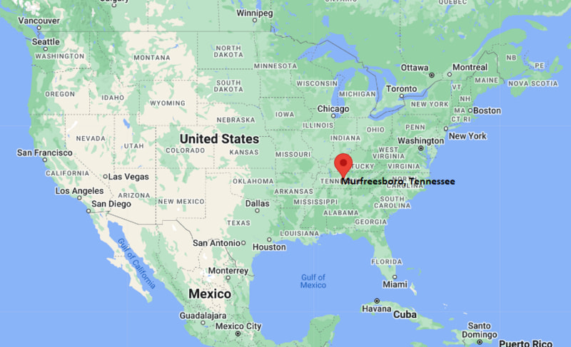
Murfreesboro Map, Tennessee, USA
Where is Murfreesboro?: The Google Map showing the location of Murfreesboro in the U.S. state of Tennessee.
Where is Murfreesboro Located?
Murfreesboro is a city located in the Rutherford County of Tennessee, United States. Murfreesboro lies between 41.3319459 Degrees North latitudes and 71.8130632 Degrees West longitudes. According to 2020 U.S.census, the population of Murfreesboro city is 152769 people and the city has a total area of 61.71 sq mi. The city has numerous parks and recreational facilities.
Most Viewed US Maps
| USA Sttae Map | USA Region Map | USA Road Map |
| USA County Map | Where is USA in World Map? | US ZIP Code Map |
| USA Time Zones Map | US State and Capitals Map | USA Physical Map |
Find 4,400+ U.S. Cities by State - Explore Their Locations and Get Detailed Information
Murfreesboro, Tennessee Quick Facts
| Attribute | Information |
|---|---|
| City | Murfreesboro |
| County | Rutherford County |
| State | Tennessee |
| State Capital | Nashville |
| US Region | South (East South Central) |
| Latitude | 35.8456° N |
| Longitude | 86.3903° W |
| Elevation | 605 ft (184 m) |
| Land Area | 62.19 sq mi |
| Water Area | 0.42 sq mi |
| Total Area | 62.61 sq mi |
| Population (2020 Census) | 152,769 |
| Population Density | Approximately 2,457 per sq mi |
| ZIP Codes | 37127, 37128, 37129, 37130 |
| Area Code | 615 |
| Time Zone Standard | Central Standard Time (CST, UTC−6) |
| Time Zone Daylight | Central Daylight Time (CDT, UTC−5) |
| Currency | United States Dollar (USD) |
| FIPS Code | 47-51560 |
| Congressional District | Tennessee's 4th Congressional District |
Transportation and Connectivity in Murfreesboro
| Category | Information |
|---|---|
| Airport Name | Nashville International Airport |
| IATA Code | BNA |
| Nearest General Aviation Airport | Murfreesboro Municipal Airport |
| Port | Port of Nashville (Cumberland River access) |
| Major Highways | Interstate 24, U.S. Highway 231, U.S. Highway 41 |
| Train/Amtrak Service | Nearest Amtrak service available in Nashville |
| Local Transit Service | Rover public transportation system |
- Interstate 24 – Major highway connecting Murfreesboro with Nashville, Chattanooga, and surrounding regions.
- U.S. Highway 231 – Important north–south route serving Rutherford County.
- U.S. Highway 41 – Historic regional highway connecting Murfreesboro with Nashville and nearby communities.
- Murfreesboro Municipal Airport provides general aviation services for the city.
Top Places to Visit in Murfreesboro, Tennessee
| Landmark Name | Type |
|---|---|
| Stones River National Battlefield | Historic Site |
| Cannonsburgh Village | Historic Village |
| Oaklands Mansion | Historic Landmark |
| Discovery Center at Murfree Spring | Science Museum |
| Barfield Crescent Park | Park |
| Stones River Greenway | Recreation Trail |
| MTSU Science Building and Campus Attractions | Educational Attraction |
| Rutherford County Courthouse | Historic Landmark |
| Earth Experience Museum | Museum |
| Gateway Island | Park and Recreation Area |
Driving Distances from Murfreesboro, Tennessee to Nearby Cities
| City | State | Distance (mi) | Approx. Drive Time |
|---|---|---|---|
| Nashville | Tennessee | 35 | 40 minutes |
| Franklin | Tennessee | 35 | 45 minutes |
| Lebanon | Tennessee | 45 | 50 minutes |
| Columbia | Tennessee | 55 | 1 hour |
| Cookeville | Tennessee | 80 | 1 hour 20 minutes |
| Chattanooga | Tennessee | 95 | 1 hour 30 minutes |
| Knoxville | Tennessee | 170 | 2 hours 45 minutes |
| Memphis | Tennessee | 210 | 3 hours 15 minutes |
| Louisville | Kentucky | 190 | 3 hours |
| Atlanta | Georgia | 210 | 3 hours 15 minutes |
Colleges and Universities in Murfreesboro, Tennessee
| Institution Name | Type | Level | Notable For |
|---|---|---|---|
| Middle Tennessee State University | Public | University | Aerospace, recording industry, business, education, and research |
| Motlow State Community College – Smyrna Campus | Public | Community College | Associate degrees, technical programs, and workforce training |
| Tennessee College of Applied Technology – Murfreesboro | Public | Technical College | Career training and applied technology programs |
| Vanderbilt University | Private | University | Research, medicine, law, and academics |
| Belmont University | Private | University | Music, business, nursing, and liberal arts |
Waterbodies in Murfreesboro, Tennessee
Stones River, West Fork Stones River, Overall Creek, Lytle Creek, Murfree Spring, and nearby Middle Tennessee waterways.
Stadiums and Sports Facilities in Murfreesboro
Johnny "Red" Floyd Stadium, Murphy Center, Middle Tennessee State University athletic facilities, McKnight Park sports complex, and local community recreation facilities.
Murfreesboro, Tennessee — Key Historical Facts
- Murfreesboro was founded in 1811 and was named after Revolutionary War hero Colonel Hardy Murfree.
- The city became the county seat of Rutherford County and developed as an agricultural and commercial center in Middle Tennessee.
- Murfreesboro served as the capital of Tennessee for a short period from 1818 to 1826 before the state capital moved to Nashville.
- The Battle of Stones River, fought during the American Civil War from 1862 to 1863, took place near the city and became one of the significant battles of the Western Theater.
- The establishment and growth of Middle Tennessee State University contributed greatly to the city's educational and cultural development.
- Today, Murfreesboro is one of Tennessee's fastest-growing cities, known for higher education, historic sites, business growth, parks, and its connection to the Nashville metropolitan area.
References
- City of Murfreesboro
- Rutherford County Government
- U.S. Census Bureau
- Stones River National Battlefield
- Tennessee Tourism
Tennessee Maps & Info
- Where is Athens
- Where is Bartlett
- Where is Brentwood
- Where is Bristol
- Where is Chattanooga
- Where is Clarksville
- Where is Collierville
- Where is Columbia
- Where is Cookeville
- Where is Crossville
- Where is Dickson
- Where is Dyersburg
- Where is East Ridge
- Where is Elizabethton
- Where is Farragut
- Where is Franklin
- Where is Gallatin
- Where is Germantown
- Where is Goodlettsville
- Where is Greeneville
- Where is Hartsville
- Where is Hendersonville
- Where is Jackson
- Where is Johnson City
- Where is Kingsport
- Where is Knoxville
- Where is La Vergne
- Where is Lakeland
- Where is Lebanon
- Where is Lewisburg
- Where is Manchester
- Where is Maryville
- Where is McMinnville
- Where is Morristown
- Where is Mount Juliet
- Where is Murfreesboro
- Where is Nolensville
- Where is Oak Ridge
- Where is Sevierville
- Where is Seymour
- Where is Shelbyville
- Where is Smyrna
- Where is Soddy-Daisy
- Where is Spring Hill
- Where is Tullahoma
- Where is White House