
Where is Dyersburg Located? - Dyersburg is a city located in the Dyer County of Tennessee, United States. Dyersburg lies between 40.2010241 Degrees North latitudes and 77.2002745 Degrees West longitudes.
Location Map of Dyersburg, Tennessee
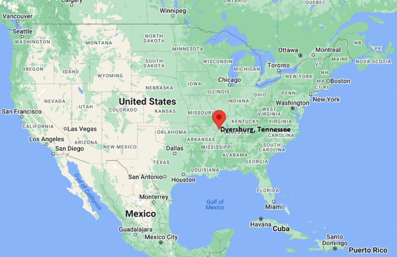
Dyersburg Map, Tennessee, USA
Where is Dyersburg?: The Google Map showing the location of Dyersburg in the U.S. state of Tennessee.
Where is Dyersburg Located?
Dyersburg is a city located in the Dyer County of Tennessee, United States. Dyersburg lies between 40.2010241 Degrees North latitudes and 77.2002745 Degrees West longitudes. According to 2020 U.S.census, the population of Dyersburg city is 16164 people and the city has a total area of 17.32 sq mi. The city has numerous parks and recreational facilities.
Most Viewed US Maps
| USA Sttae Map | USA Region Map | USA Road Map |
| USA County Map | Where is USA in World Map? | US ZIP Code Map |
| USA Time Zones Map | US State and Capitals Map | USA Physical Map |
Find 4,400+ U.S. Cities by State - Explore Their Locations and Get Detailed Information
Dyersburg, Tennessee Quick Facts
| Property | Details |
|---|---|
| City | Dyersburg |
| County | Dyer County |
| State | Tennessee |
| State Capital | Nashville |
| US Region | Southern United States |
| Latitude | 36.0348°N |
| Longitude | 89.3856°W |
| Elevation | 302 ft (92 m) |
| Land Area | 17.47 sq mi |
| Water Area | 0.10 sq mi |
| Total Area | 17.57 sq mi |
| Population (2020 Census) | 16,164 |
| Population Density | About 925 per sq mi |
| ZIP Codes | 38024, 38025 |
| Area Code | 731 |
| Time Zone Standard | Central Standard Time (CST), UTC -6 |
| Time Zone Daylight | Central Daylight Time (CDT), UTC -5 |
| Currency | United States Dollar (USD) |
| FIPS Code | 47-22240 |
| Congressional District | Tennessee's 8th Congressional District |
Nearby Cities to Dyersburg, Tennessee
- Newbern, Tennessee - East - 10 mi
- Halls, Tennessee - Southeast - 14 mi
- Ripley, Tennessee - South - 26 mi
- Union City, Tennessee - North - 34 mi
- Blytheville, Arkansas - West - 36 mi
- Covington, Tennessee - South - 42 mi
- Kennett, Missouri - Northwest - 31 mi
- Martin, Tennessee - Northeast - 42 mi
- Jackson, Tennessee - East - 74 mi
- Memphis, Tennessee - Southwest - 79 mi
Dyersburg, Tennessee Climate and Weather Overview
| Month | Avg High (°F) | Avg Low (°F) | Avg Rainfall (in) |
|---|---|---|---|
| January | 48 | 30 | 4.5 |
| April | 71 | 49 | 5.2 |
| July | 90 | 71 | 3.9 |
| October | 73 | 50 | 3.3 |
| Annual | 71 | 50 | 53.0 |
| Climate Attribute | Details |
|---|---|
| Climate Classification (Köppen) | Humid Subtropical (Cfa) |
| Annual Rainfall | About 53.0 inches |
| Annual Sunshine Days | Approximately 214 days |
| Hurricane/Tornado Risk | Very low hurricane risk; moderate tornado risk |
| Snowfall | About 4 inches annually |
Driving Distances from Dyersburg, Tennessee
| City | State | Distance (mi) | Approx. Drive Time |
|---|---|---|---|
| Newbern | Tennessee | 10 | 12 min |
| Halls | Tennessee | 14 | 18 min |
| Ripley | Tennessee | 26 | 30 min |
| Kennett | Missouri | 31 | 35 min |
| Union City | Tennessee | 34 | 40 min |
| Blytheville | Arkansas | 36 | 40 min |
| Covington | Tennessee | 42 | 45 min |
| Martin | Tennessee | 42 | 50 min |
| Jackson | Tennessee | 74 | 1 hr 10 min |
| Memphis | Tennessee | 79 | 1 hr 20 min |
Transportation and Connectivity in Dyersburg, Tennessee
| Transportation | Details |
|---|---|
| Airport Name | Dyersburg Regional Airport |
| IATA Code | DYR |
| Port | Port of Cates Landing (nearby) |
| Major Highways | Interstate 155, U.S. Highway 51, U.S. Highway 412, State Route 78 |
| Train/Passenger Rail | No passenger rail service |
| Local Bus/Transit Service | Dyersburg Area Rural Transit (DART) |
- Interstate 155 and U.S. Highways 51 and 412 provide convenient access to Memphis, Jackson, Missouri, and western Kentucky.
- Dyersburg Regional Airport supports general aviation and corporate aircraft operations.
- Dyersburg Area Rural Transit (DART) provides public transportation within the city and surrounding communities.
- The nearby Port of Cates Landing on the Mississippi River supports regional commercial shipping and economic development.
Key Landmarks and Places to Visit in Dyersburg, Tennessee
| Landmark Name | Type |
|---|---|
| Dyersburg Mall | Shopping Center |
| Dyersburg State Community College Campus | Educational Campus |
| Shell City Park | City Park |
| Okeena Park | Community Park |
| Dyer County Veterans' Walk of Fame | Memorial |
| The Farms Golf Club | Golf & Recreation |
| Lower Hatchie National Wildlife Refuge | Wildlife Refuge |
| Reelfoot Lake State Park | State Park |
| Discovery Park of America | Museum & Heritage Park |
| Port of Cates Landing | River Port |
Colleges and Universities in Dyersburg, Tennessee
| Institution | Type | Level | Notable For |
|---|---|---|---|
| Dyersburg State Community College | Public | Community College | Associate degrees, workforce development, and university transfer programs |
| University of Tennessee at Martin | Public | University | Agriculture, business, education, and engineering technology |
| Freed-Hardeman University | Private | University | Liberal arts, business, education, and healthcare |
| Jackson State Community College | Public | Community College | Career training and transfer education |
| Union University | Private | University | Business, nursing, pharmacy, and liberal arts |
Waterbodies in Dyersburg, Tennessee
Forked Deer River, Mississippi River, Obion River, Hatchie River, Reelfoot Lake, Running Reelfoot Bayou, Lake Isom, Cypress Creek.
Golf Courses in Dyersburg, Tennessee
The Farms Golf Club, Dyersburg Country Club, WynRidge Green Golf Course, Reelfoot Lake Golf Course, Union City Country Club, Bent Tree Golf Club.
Dyersburg, Tennessee - Key Historical Facts
- Dyersburg was established in 1825 and named after Robert Henry Dyer, an early Tennessee legislator who donated land for the county seat.
- The city developed as a regional center for cotton production, river commerce, and agriculture due to its location near the Mississippi River.
- Railroad expansion during the late 19th century strengthened Dyersburg's role as a transportation and commercial hub in West Tennessee.
- Manufacturing, food processing, healthcare, and education gradually diversified the local economy throughout the 20th century.
- The development of Interstate 155 further improved regional connectivity and encouraged industrial and commercial growth.
- Today, Dyersburg serves as the economic center of Dyer County and is known for its educational institutions, agricultural heritage, manufacturing sector, and access to outdoor recreation along the Mississippi River.
References
Tennessee Maps & Info
- Where is Athens
- Where is Bartlett
- Where is Brentwood
- Where is Bristol
- Where is Chattanooga
- Where is Clarksville
- Where is Collierville
- Where is Columbia
- Where is Cookeville
- Where is Crossville
- Where is Dickson
- Where is Dyersburg
- Where is East Ridge
- Where is Elizabethton
- Where is Farragut
- Where is Franklin
- Where is Gallatin
- Where is Germantown
- Where is Goodlettsville
- Where is Greeneville
- Where is Hartsville
- Where is Hendersonville
- Where is Jackson
- Where is Johnson City
- Where is Kingsport
- Where is Knoxville
- Where is La Vergne
- Where is Lakeland
- Where is Lebanon
- Where is Lewisburg
- Where is Manchester
- Where is Maryville
- Where is McMinnville
- Where is Morristown
- Where is Mount Juliet
- Where is Murfreesboro
- Where is Nolensville
- Where is Oak Ridge
- Where is Sevierville
- Where is Seymour
- Where is Shelbyville
- Where is Smyrna
- Where is Soddy-Daisy
- Where is Spring Hill
- Where is Tullahoma
- Where is White House