
Where is Soddy-Daisy Located? - Soddy-Daisy is a city located in the Hamilton County of Tennessee, United States. Soddy-Daisy lies between 40.6317638 Degrees North latitudes and 75.4732384 Degrees West longitudes.
Location Map of Soddy-Daisy, Tennessee
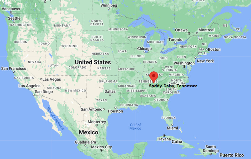
Soddy-Daisy Map, Tennessee, USA
Where is Soddy-Daisy?: The Google Map showing the location of Soddy-Daisy in the U.S. state of Tennessee.
Where is Soddy-Daisy Located?
Soddy-Daisy is a city located in the Hamilton County of Tennessee, United States. Soddy-Daisy lies between 40.6317638 Degrees North latitudes and 75.4732384 Degrees West longitudes. According to 2020 U.S.census, the population of Soddy-Daisy city is 13070 people and the city has a total area of 23.15 sq mi. The city has numerous parks and recreational facilities.
Most Viewed US Maps
| USA Sttae Map | USA Region Map | USA Road Map |
| USA County Map | Where is USA in World Map? | US ZIP Code Map |
| USA Time Zones Map | US State and Capitals Map | USA Physical Map |
Find 4,400+ U.S. Cities by State - Explore Their Locations and Get Detailed Information
Soddy-Daisy, Tennessee Quick Facts
| Attribute | Details |
|---|---|
| City | Soddy-Daisy |
| County | Hamilton County |
| State | Tennessee |
| State Capital | Nashville |
| US Region | Southern United States |
| Latitude | 35.2351° N |
| Longitude | 85.1844° W |
| Elevation | 650 ft (198 m) |
| Land Area (sq mi) | 23.43 |
| Water Area (sq mi) | 0.43 |
| Total Area (sq mi) | 23.86 |
| Population (2020 Census) | 13,430 |
| Population Density (per sq mi) | 573.2 |
| ZIP Codes | 37379 |
| Area Code | 423 |
| Time Zone Standard | Eastern Standard Time (EST), UTC−5 |
| Time Zone Daylight | Eastern Daylight Time (EDT), UTC−4 |
| Currency | United States Dollar (USD) |
| FIPS Code | 4770860 |
| Congressional District | 3rd Congressional District |
Transportation and Connectivity in Soddy-Daisy
| Transportation Feature | Details |
|---|---|
| Airport Name | Chattanooga Metropolitan Airport provides commercial air service. |
| IATA Code | CHA |
| Port | Chattanooga Riverfront and Tennessee River access nearby |
| Major Highways | U.S. Highway 27, Tennessee State Route 111, and Tennessee State Route 153 |
| Train/Amtrak Service | Amtrak service is available from nearby regional stations. |
| Local Bus/Transit Service | CartA provides public transportation services in the Chattanooga area. |
- U.S. Highway 27 connects Soddy-Daisy with Chattanooga and northern Hamilton County.
- Tennessee State Route 111 provides access toward the Cumberland Plateau region.
- The city is located near Chickamauga Lake and the Tennessee River.
- Chattanooga Metropolitan Airport provides regional and national flight connections.
Top Places to Visit in Soddy-Daisy, Tennessee
| Landmark Name | Type |
|---|---|
| North Chickamauga Creek Gorge | Natural Attraction |
| Chickamauga Lake | Recreation Area |
| Greenway Farms | Park and Recreation Area |
| Harrison Bay State Park | State Park |
| North Chickamauga Creek Wildlife Management Area | Wildlife Area |
| Soddy Daisy Community Park | Community Park |
| Prentice Cooper State Forest | Forest Recreation Area |
| Chattanooga Riverfront | Tourist Attraction |
| Tennessee River Gorge | Natural Landmark |
| Signal Mountain Area | Scenic Area |
Driving Distances from Soddy-Daisy, Tennessee to Nearby Cities
| City | State | Distance (mi) | Approx. Drive Time |
|---|---|---|---|
| Chattanooga | Tennessee | 15 | 25 min |
| Signal Mountain | Tennessee | 12 | 20 min |
| Cleveland | Tennessee | 35 | 45 min |
| Dayton | Tennessee | 40 | 50 min |
| Knoxville | Tennessee | 100 | 1 hr 40 min |
| Nashville | Tennessee | 150 | 2 hr 20 min |
| Atlanta | Georgia | 150 | 2 hr 20 min |
| Birmingham | Alabama | 160 | 2 hr 30 min |
| Huntsville | Alabama | 90 | 1 hr 30 min |
| Asheville | North Carolina | 150 | 2 hr 30 min |
Colleges and Universities near Soddy-Daisy, Tennessee
| Institution Name | Type | Level | Notable For |
|---|---|---|---|
| University of Tennessee at Chattanooga | Public | University | Business, engineering, health sciences, and research programs |
| Chattanooga State Community College | Public | Community College | Technical education, workforce training, and associate degrees |
| Lee University | Private | University | Arts, sciences, education, and professional programs |
| Southern Adventist University | Private | University | Health sciences, business, and liberal arts programs |
Waterbodies in Soddy-Daisy, Tennessee
Chickamauga Lake, Tennessee River, North Chickamauga Creek, and nearby Appalachian waterways
Golf Courses near Soddy-Daisy, Tennessee
Montlake Golf Course, Bear Trace at Harrison Bay, Eagle Bluff Golf Club, and nearby Chattanooga area golf facilities
Key Landmarks and Places to Visit in Soddy-Daisy, Tennessee
| Landmark Name | Type |
|---|---|
| North Chickamauga Creek Gorge | Natural Attraction |
| Chickamauga Lake | Recreation Area |
| Greenway Farms | Park and Recreation Area |
| Harrison Bay State Park | State Park |
| North Chickamauga Creek Wildlife Management Area | Wildlife Area |
| Prentice Cooper State Forest | Forest Recreation Area |
| Soddy Daisy Community Park | Community Park |
| Tennessee River Gorge | Natural Landmark |
| Signal Mountain Area | Scenic Area |
| Chattanooga Riverfront | Tourist Attraction |
Waterbodies in Soddy-Daisy, Tennessee
Chickamauga Lake, Tennessee River, North Chickamauga Creek, and nearby Appalachian waterways
Golf Courses near Soddy-Daisy, Tennessee
Montlake Golf Course, Bear Trace at Harrison Bay, Eagle Bluff Golf Club, and nearby Chattanooga area golf facilities
Soddy-Daisy, Tennessee — Key Historical Facts
- Soddy-Daisy was formed through the merger of the communities of Soddy and Daisy in 1969.
- The area has a history connected to Native American settlements, farming, mining, and river transportation.
- The name Soddy is believed to have originated from the Cherokee word "Sauta," while Daisy was named after a local coal mining community.
- Coal mining and industrial activities played an important role in the area's early economic development.
- Soddy-Daisy grew as a residential community while maintaining access to natural resources, lakes, and outdoor recreation areas.
References
- City of Soddy-Daisy Official Website
- Hamilton County Government
- U.S. Census Bureau
- Tennessee Tourism
- Harrison Bay State Park
- University of Tennessee at Chattanooga
Tennessee Maps & Info
- Where is Athens
- Where is Bartlett
- Where is Brentwood
- Where is Bristol
- Where is Chattanooga
- Where is Clarksville
- Where is Collierville
- Where is Columbia
- Where is Cookeville
- Where is Crossville
- Where is Dickson
- Where is Dyersburg
- Where is East Ridge
- Where is Elizabethton
- Where is Farragut
- Where is Franklin
- Where is Gallatin
- Where is Germantown
- Where is Goodlettsville
- Where is Greeneville
- Where is Hartsville
- Where is Hendersonville
- Where is Jackson
- Where is Johnson City
- Where is Kingsport
- Where is Knoxville
- Where is La Vergne
- Where is Lakeland
- Where is Lebanon
- Where is Lewisburg
- Where is Manchester
- Where is Maryville
- Where is McMinnville
- Where is Morristown
- Where is Mount Juliet
- Where is Murfreesboro
- Where is Nolensville
- Where is Oak Ridge
- Where is Sevierville
- Where is Seymour
- Where is Shelbyville
- Where is Smyrna
- Where is Soddy-Daisy
- Where is Spring Hill
- Where is Tullahoma
- Where is White House