
Where is Gallatin Located? - Gallatin is a city located in the Sumner County of Tennessee, United States. Gallatin lies between 39.9625984 Degrees North latitudes and 76.727745 Degrees West longitudes.
Location Map of Gallatin, Tennessee
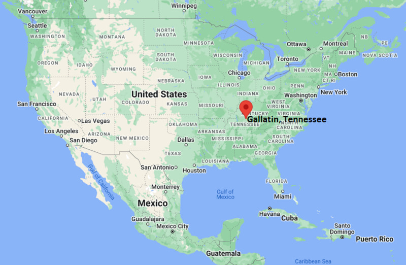
Gallatin Map, Tennessee, USA
Where is Gallatin?: The Google Map showing the location of Gallatin in the U.S. state of Tennessee.
Where is Gallatin Located?
Gallatin is a city located in the Sumner County of Tennessee, United States. Gallatin lies between 39.9625984 Degrees North latitudes and 76.727745 Degrees West longitudes. According to 2020 U.S.census, the population of Gallatin city is 44431 people and the city has a total area of 31.83 sq mi. The city has numerous parks and recreational facilities.
Most Viewed US Maps
| USA Sttae Map | USA Region Map | USA Road Map |
| USA County Map | Where is USA in World Map? | US ZIP Code Map |
| USA Time Zones Map | US State and Capitals Map | USA Physical Map |
Find 4,400+ U.S. Cities by State - Explore Their Locations and Get Detailed Information
Gallatin, Tennessee Quick Facts
| Property | Information |
|---|---|
| City | Gallatin |
| County | Sumner County |
| State | Tennessee |
| State Capital | Nashville |
| US Region | South |
| Latitude | 36.3884°N |
| Longitude | 86.4467°W |
| Elevation | 538 ft (164 m) |
| Land Area | 31.70 sq mi |
| Water Area | 0.80 sq mi |
| Total Area | 32.50 sq mi |
| Population (2020 Census) | 44,431 |
| Population Density | 1,401 per sq mi |
| ZIP Codes | 37066 |
| Area Code | 615 |
| Time Zone Standard | Central Standard Time (CST, UTC−6) |
| Time Zone Daylight | Central Daylight Time (CDT, UTC−5) |
| Currency | United States Dollar (USD) |
| FIPS Code | 47-28280 |
| Congressional District | Tennessee's 6th Congressional District |
Nearby Cities to Gallatin, Tennessee
- Hendersonville, Tennessee - Southwest - 13 mi
- Portland, Tennessee - North - 17 mi
- White House, Tennessee - West - 15 mi
- Goodlettsville, Tennessee - Southwest - 21 mi
- Lebanon, Tennessee - South - 22 mi
- Mount Juliet, Tennessee - South - 23 mi
- Springfield, Tennessee - Northwest - 30 mi
- Nashville, Tennessee - Southwest - 30 mi
- Franklin, Kentucky - North - 34 mi
- Murfreesboro, Tennessee - Southeast - 44 mi
Driving Distances from Gallatin, Tennessee
| City | State | Distance (mi) | Approx. Drive Time |
|---|---|---|---|
| Hendersonville | Tennessee | 13 | 20 minutes |
| White House | Tennessee | 15 | 20 minutes |
| Portland | Tennessee | 17 | 22 minutes |
| Goodlettsville | Tennessee | 21 | 30 minutes |
| Lebanon | Tennessee | 22 | 30 minutes |
| Mount Juliet | Tennessee | 23 | 30 minutes |
| Springfield | Tennessee | 30 | 40 minutes |
| Nashville | Tennessee | 30 | 40 minutes |
| Franklin | Kentucky | 34 | 40 minutes |
| Murfreesboro | Tennessee | 44 | 55 minutes |
Transportation and Connectivity in Gallatin, Tennessee
| Mode | Details |
|---|---|
| Airport Name | Nashville International Airport |
| IATA Code | BNA |
| Port | Not Applicable |
| Major Highways | State Route 109, U.S. Highway 31E, State Route 386 (Vietnam Veterans Boulevard), State Route 25 |
| Train/Amtrak Service | No passenger rail service; nearest Amtrak station is Nashville |
| Local Bus/Transit Service | WeGo Public Transit regional connections and local transportation services |
- State Route 386 provides a direct expressway connection between Gallatin and the Nashville metropolitan area.
- U.S. Highway 31E connects the city with Hendersonville, Goodlettsville, and Bowling Green, Kentucky.
- State Route 109 serves as a major north-south corridor linking Gallatin with Interstate 40 and surrounding communities.
- Nashville International Airport, about 30 miles away, provides domestic and international air service.
What are top Places to Visit in Gallatin, Tennessee
| Landmark Name | Type |
|---|---|
| Bledsoe Creek State Park | State Park |
| Old Hickory Lake | Lake & Recreation Area |
| Sumner County Museum | History Museum |
| Historic Downtown Gallatin | Historic District |
| Triple Creek Park | Community Park |
| Lock 4 Park | Riverfront Park |
| Palace Theater | Historic Theater |
| Gallatin Marina | Marina |
| Rose Mont | Historic House Museum |
| Fairvue Plantation | Historic Landmark |
Colleges and Universities in Gallatin, Tennessee
| Institution Name | Type | Level | Notable For |
|---|---|---|---|
| Volunteer State Community College | Public | Community College | Associate degrees, workforce training, and university transfer programs |
| Welch College | Private | College | Christian liberal arts and ministry education |
| Tennessee State University – Nashville | Public | University | Research, agriculture, business, and engineering programs |
| Middle Tennessee State University | Public | University | Business, aerospace, education, and research |
| Sumner County Schools | Public | K–12 District | Public education serving Gallatin and surrounding communities |
Waterbodies in Gallatin, Tennessee
Old Hickory Lake, Cumberland River, Bledsoe Creek, Station Camp Creek, Drakes Creek, Town Creek, Mansker Creek, Caney Fork Creek
Golf Courses in Gallatin, Tennessee
Foxland Harbor Golf Club, Long Hollow Golf Course, Fairvue Plantation Golf Club, Country Hills Golf Course, Bluegrass Yacht & Country Club, The Club at Five Oaks
Gallatin, Tennessee — Key Historical Facts
- Gallatin was established in 1802 and named after Albert Gallatin, who served as the U.S. Secretary of the Treasury under Presidents Thomas Jefferson and James Madison.
- The city became the county seat of Sumner County and developed as an important agricultural and commercial center in Middle Tennessee.
- Construction of Old Hickory Dam and the creation of Old Hickory Lake in the 1950s enhanced recreation, transportation, and residential development.
- Gallatin experienced significant industrial and manufacturing growth during the twentieth century, attracting automotive, healthcare, and distribution industries.
- Today, Gallatin is known for its historic downtown, Volunteer State Community College, lakeside recreation, and its role as one of the fastest-growing communities in the Nashville metropolitan area.
References
Tennessee Maps & Info
- Where is Athens
- Where is Bartlett
- Where is Brentwood
- Where is Bristol
- Where is Chattanooga
- Where is Clarksville
- Where is Collierville
- Where is Columbia
- Where is Cookeville
- Where is Crossville
- Where is Dickson
- Where is Dyersburg
- Where is East Ridge
- Where is Elizabethton
- Where is Farragut
- Where is Franklin
- Where is Gallatin
- Where is Germantown
- Where is Goodlettsville
- Where is Greeneville
- Where is Hartsville
- Where is Hendersonville
- Where is Jackson
- Where is Johnson City
- Where is Kingsport
- Where is Knoxville
- Where is La Vergne
- Where is Lakeland
- Where is Lebanon
- Where is Lewisburg
- Where is Manchester
- Where is Maryville
- Where is McMinnville
- Where is Morristown
- Where is Mount Juliet
- Where is Murfreesboro
- Where is Nolensville
- Where is Oak Ridge
- Where is Sevierville
- Where is Seymour
- Where is Shelbyville
- Where is Smyrna
- Where is Soddy-Daisy
- Where is Spring Hill
- Where is Tullahoma
- Where is White House