Map of Sumner County - Sumner County is a county located in the U.S. state of Tennessee. Sumner County Map showing cities, highways, important places and water bodies. Get Where is Sumner County located in the map, major cities in Sumner county, population, areas, and places of interest.
Map of Sumner County, Tennessee
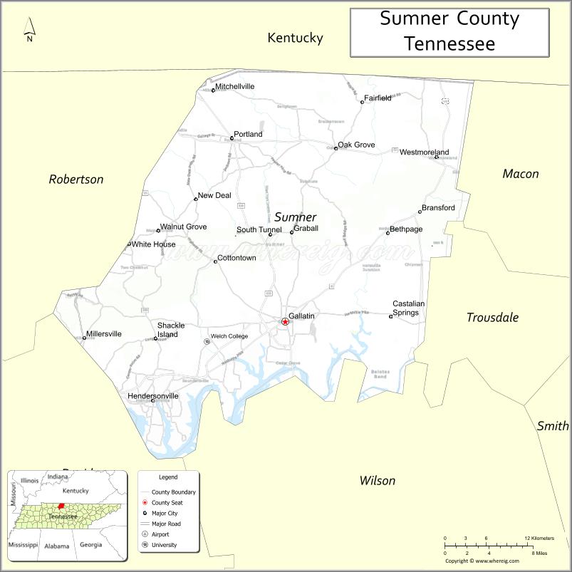
About Sumner County Map, Tennessee: The map showing the county boundary, county seat, major cities, highways and neighbouring counties.
Tennessee More Maps & Info
About Sumner County, Tennessee
Sumner County is a county located in the U.S. state of Tennessee. It's county seat is Gallatin. As per 2020 census, the population of Sumner County is 200557 people and population density is square miles. According to the United States Census Bureau, the county has a total area of 529 sq mi (1,370 km2). Sumner County was established on 1786.
Sumner County Facts
| Continent | North America |
| Country | United States |
| State | Tennessee |
| County Seat | Gallatin |
| Largest City/Town | Hendersonville |
| Established | 1786 |
| Total Area | 552 sq mi |
| Land Area | 529 sq mi |
| Water Area | 23 sq mi |
| Population | 196,281 (Census 2020) |
| Population Density | 371 people per sq mi |
| Time Zone | Central (CST) |
| Major Highways | I-65, TN-386, US-31E, US-231 |
| Neighboring Counties | Robertson County, Davidson County, Wilson County, Trousdale County, Macon County, Allen County (KY) |
| Famous For | Old Hickory Lake, country music history, growing suburbs |
| Top Attractions | Bledsoe Creek State Park, Old Hickory Lake, Historic Cragfont |
| Official Website | https://www.sumnertn.org |
Cities and Towns in Sumner County, Tennessee
- Gallatin (county seat) – 44,431 (Census 2020)
- Hendersonville – 61,753 (Census 2020)
- Portland – 12,154 (Census 2020)
- Westmoreland – 2,418 (Census 2020)
Roads and Highways in Sumner County
Sumner County is well connected to Nashville and surrounding areas through a network of interstates and state highways.
- Interstate 65 (I-65) – Runs north-south connecting the county to Nashville and Kentucky
- Tennessee State Route 386 (TN-386) – Main route linking Hendersonville and Gallatin to Nashville
- U.S. Route 31E (US-31E) – Connects Gallatin to Nashville and northern Tennessee
- U.S. Route 231 (US-231) – Runs through the county connecting to Lebanon and Kentucky
Neighboring Counties of Sumner County
- Robertson County (west)
- Davidson County (southwest)
- Wilson County (south)
- Trousdale County (east)
- Macon County (northeast)
- Allen County, KY (north)
Top Attractions in Sumner County
Sumner County offers a mix of lakeside recreation, historic sites, and suburban attractions near Nashville.
- Bledsoe Creek State Park – Popular for hiking, camping, and lake access
- Old Hickory Lake – Great for boating, fishing, and waterfront views
- Historic Cragfont – Preserved 18th-century mansion with guided tours
- Rock Castle – Historic home of General Daniel Smith
- Drakes Creek Park – Family-friendly park with trails and sports fields
- Triple Creek Park – Large park with playgrounds and open spaces
- Sumner County Museum – Showcases local history and heritage
Distance from Sumner County to Nearby Cities
- Gallatin to Nashville – 30 mi (48 km)
- Gallatin to Bowling Green – 45 mi (72 km)
- Gallatin to Clarksville – 60 mi (97 km)
- Gallatin to Lebanon – 25 mi (40 km)
- Gallatin to Knoxville – 160 mi (257 km)
FAQs about Sumner County
Sumner County is known for Old Hickory Lake, historic sites, and its growing suburban communities.
Gallatin is the county seat of Sumner County.
Hendersonville is the largest city in the county.
Yes, it is located just northeast of Nashville.
Visitors can enjoy boating, fishing, hiking, and park activities around the county.
- Anderson County Map
- Bedford County Map
- Benton County Map
- Bledsoe County Map
- Blount County Map
- Bradley County Map
- Campbell County Map
- Cannon County Map
- Carroll County Map
- Carter County Map
- Cheatham County Map
- Chester County Map
- Claiborne County Map
- Clay County Map
- Cocke County Map
- Coffee County Map
- Crockett County Map
- Cumberland County Map
- Davidson County Map
- Decatur County Map
- DeKalb County Map
- Dickson County Map
- Dyer County Map
- Fayette County Map
- Fentress County Map
- Franklin County Map
- Gibson County Map
- Giles County Map
- Grainger County Map
- Greene County Map
- Grundy County Map
- Hamblen County Map
- Hamilton County Map
- Hancock County Map
- Hardeman County Map
- Hardin County Map
- Hawkins County Map
- Haywood County Map
- Henderson County Map
- Henry County Map
- Hickman County Map
- Houston County Map
- Humphreys County Map
- Jackson County Map
- Jefferson County Map
- Johnson County Map
- Knox County Map
- Lake County Map
- Lauderdale County Map
- Lawrence County Map
- Lewis County Map
- Lincoln County Map
- Loudon County Map
- McMinn County Map
- McNairy County Map
- Macon County Map
- Madison County Map
- Marion County Map
- Marshall County Map
- Maury County Map
- Meigs County Map
- Monroe County Map
- Montgomery County Map
- Moore County Map
- Morgan County Map
- Obion County Map
- Overton County Map
- Perry County Map
- Pickett County Map
- Polk County Map
- Putnam County Map
- Rhea County Map
- Roane County Map
- Robertson County Map
- Rutherford County Map
- Scott County Map
- Sequatchie County Map
- Sevier County Map
- Shelby County Map
- Smith County Map
- Stewart County Map
- Sullivan County Map
- Sumner County Map
- Tipton County Map
- Trousdale County Map
- Unicoi County Map
- Union County Map
- Van Buren County Map
- Warren County Map
- Washington County Map
- Wayne County Map
- Weakley County Map
- White County Map
- Williamson County Map
- Wilson County Map
- Alabama Counties
- Alaska boroughs
- Arizona Counties
- Arkansas Counties
- California County Map
- Colorado Counties
- Connecticut Counties
- Delaware Counties
- Florida County Map
- Georgia County Map
- Hawaii Counties
- Idaho Counties
- Illinois Counties
- Indiana Counties
- Iowa Counties
- Kansas Counties
- Kentucky Counties
- Louisiana Counties
- Maine Counties
- Maryland Counties
- Massachusetts Counties
- Michigan County Map
- Minnesota Counties
- Mississippi Counties
- Missouri Counties
- Montana Counties
- Nebraska Counties
- Nevada Counties
- New York Counties
- New Hampshire Counties
- New Jersey Counties
- New Mexico Counties
- North Carolina Counties
- North Dakota Counties
- Ohio County Map
- Oklahoma Counties
- Oregon Counties
- Pennsylvania Counties
- Rhode Island Counties
- South Carolina Counties
- South Dakota Counties
- Map of Tennessee
- Texas County Map
- Utah Counties
- Vermont Counties
- Virginia Counties
- Washington Counties
- West Virginia Counties
- Wisconsin Counties
- Wyoming Counties