Map of Rhea County - Rhea County is a county located in the U.S. state of Tennessee. Rhea County Map showing cities, highways, important places and water bodies. Get Where is Rhea County located in the map, major cities in Rhea county, population, areas, and places of interest.
Map of Rhea County, Tennessee
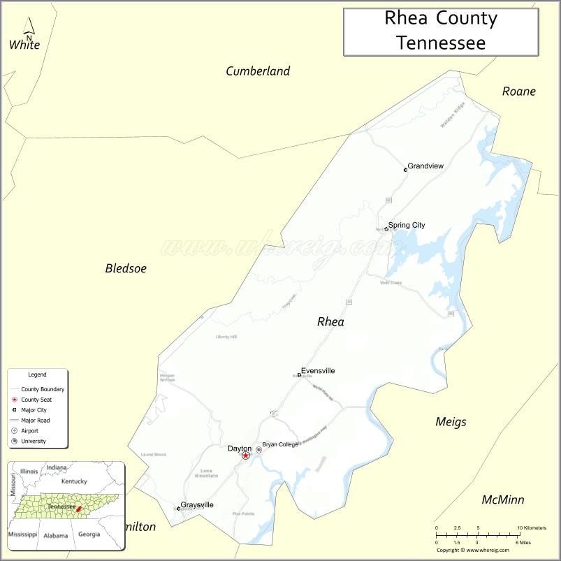
About Rhea County Map, Tennessee: The map showing the county boundary, county seat, major cities, highways and neighbouring counties.
Tennessee More Maps & Info
About Rhea County, Tennessee
Rhea County is a county located in the U.S. state of Tennessee. It's county seat is Dayton. As per 2020 census, the population of Rhea County is 33136 people and population density is square miles. According to the United States Census Bureau, the county has a total area of 316 sq mi (818 km2). Rhea County was established on 1807.
Rhea County Facts
| Continent | North America |
| Country | United States |
| State | Tennessee |
| County Seat | Dayton |
| Largest City/Town | Dayton |
| Established | 1807 |
| Total Area | 336 sq mi |
| Land Area | 316 sq mi |
| Water Area | 20 sq mi |
| Population | 32,870 (Census 2020) |
| Population Density | 104 people per sq mi |
| Time Zone | Eastern (EST) |
| Major Highways | US-27, TN-30, TN-60 |
| Neighboring Counties | Roane County, Meigs County, Hamilton County, Bledsoe County |
| Famous For | Scopes Trial, Tennessee River, outdoor recreation |
| Top Attractions | Dayton Scopes Trial Museum, Chickamauga Lake, Laurel-Snow State Natural Area |
| Official Website | https://www.rheacountytn.gov |
Cities and Towns in Rhea County, Tennessee
- Dayton (county seat) – 7,065 (Census 2020)
- Graysville – 1,502 (Census 2020)
- Spring City – 1,949 (Census 2020)
- Evensville – 0 (unincorporated community)
Roads and Highways in Rhea County
Rhea County is served by several key highways that connect it to nearby cities and provide easy access across eastern Tennessee.
- U.S. Route 27 (US-27) – Runs north-south connecting Dayton to Chattanooga and Harriman
- Tennessee State Route 30 (TN-30) – East-west route linking Dayton to Decatur and Pikeville
- Tennessee State Route 60 (TN-60) – Connects Spring City to Dayton and Cleveland
Neighboring Counties of Rhea County
- Roane County (north)
- Meigs County (west)
- Hamilton County (south)
- Bledsoe County (east)
Top Attractions in Rhea County
Rhea County offers a mix of history and outdoor activities, especially around the Tennessee River and nearby natural areas.
- Scopes Trial Museum – Highlights the famous 1925 trial held in Dayton
- Chickamauga Lake – Popular for boating, fishing, and scenic views
- Laurel-Snow State Natural Area – Known for waterfalls, hiking trails, and rock formations
- Tennessee River – Great for water recreation and relaxing views
- Rhea County Courthouse – Historic site tied to the Scopes Trial
- Dayton City Park – Local park with walking trails and family spaces
- Watts Bar Dam – Offers scenic overlooks and fishing spots
Distance from Rhea County to Nearby Cities
- Dayton to Chattanooga – 38 mi (61 km)
- Dayton to Knoxville – 88 mi (142 km)
- Dayton to Nashville – 145 mi (233 km)
- Dayton to Cleveland – 32 mi (51 km)
- Dayton to Crossville – 55 mi (89 km)
FAQs about Rhea County
Rhea County is best known for the 1925 Scopes Trial, a famous court case about teaching evolution.
Dayton is the county seat and the largest town in Rhea County.
Visitors can enjoy boating, fishing, hiking, and exploring natural areas like Laurel-Snow.
The Tennessee River flows along the county, offering many recreational opportunities.
Rhea County is in the Eastern Time Zone (EST).
- Anderson County Map
- Bedford County Map
- Benton County Map
- Bledsoe County Map
- Blount County Map
- Bradley County Map
- Campbell County Map
- Cannon County Map
- Carroll County Map
- Carter County Map
- Cheatham County Map
- Chester County Map
- Claiborne County Map
- Clay County Map
- Cocke County Map
- Coffee County Map
- Crockett County Map
- Cumberland County Map
- Davidson County Map
- Decatur County Map
- DeKalb County Map
- Dickson County Map
- Dyer County Map
- Fayette County Map
- Fentress County Map
- Franklin County Map
- Gibson County Map
- Giles County Map
- Grainger County Map
- Greene County Map
- Grundy County Map
- Hamblen County Map
- Hamilton County Map
- Hancock County Map
- Hardeman County Map
- Hardin County Map
- Hawkins County Map
- Haywood County Map
- Henderson County Map
- Henry County Map
- Hickman County Map
- Houston County Map
- Humphreys County Map
- Jackson County Map
- Jefferson County Map
- Johnson County Map
- Knox County Map
- Lake County Map
- Lauderdale County Map
- Lawrence County Map
- Lewis County Map
- Lincoln County Map
- Loudon County Map
- McMinn County Map
- McNairy County Map
- Macon County Map
- Madison County Map
- Marion County Map
- Marshall County Map
- Maury County Map
- Meigs County Map
- Monroe County Map
- Montgomery County Map
- Moore County Map
- Morgan County Map
- Obion County Map
- Overton County Map
- Perry County Map
- Pickett County Map
- Polk County Map
- Putnam County Map
- Rhea County Map
- Roane County Map
- Robertson County Map
- Rutherford County Map
- Scott County Map
- Sequatchie County Map
- Sevier County Map
- Shelby County Map
- Smith County Map
- Stewart County Map
- Sullivan County Map
- Sumner County Map
- Tipton County Map
- Trousdale County Map
- Unicoi County Map
- Union County Map
- Van Buren County Map
- Warren County Map
- Washington County Map
- Wayne County Map
- Weakley County Map
- White County Map
- Williamson County Map
- Wilson County Map
- Alabama Counties
- Alaska boroughs
- Arizona Counties
- Arkansas Counties
- California County Map
- Colorado Counties
- Connecticut Counties
- Delaware Counties
- Florida County Map
- Georgia County Map
- Hawaii Counties
- Idaho Counties
- Illinois Counties
- Indiana Counties
- Iowa Counties
- Kansas Counties
- Kentucky Counties
- Louisiana Counties
- Maine Counties
- Maryland Counties
- Massachusetts Counties
- Michigan County Map
- Minnesota Counties
- Mississippi Counties
- Missouri Counties
- Montana Counties
- Nebraska Counties
- Nevada Counties
- New York Counties
- New Hampshire Counties
- New Jersey Counties
- New Mexico Counties
- North Carolina Counties
- North Dakota Counties
- Ohio County Map
- Oklahoma Counties
- Oregon Counties
- Pennsylvania Counties
- Rhode Island Counties
- South Carolina Counties
- South Dakota Counties
- Map of Tennessee
- Texas County Map
- Utah Counties
- Vermont Counties
- Virginia Counties
- Washington Counties
- West Virginia Counties
- Wisconsin Counties
- Wyoming Counties