Map of Sullivan County - Sullivan County is a county located in the U.S. state of Tennessee. Sullivan County Map showing cities, highways, important places and water bodies. Get Where is Sullivan County located in the map, major cities in Sullivan county, population, areas, and places of interest.
Map of Sullivan County, Tennessee
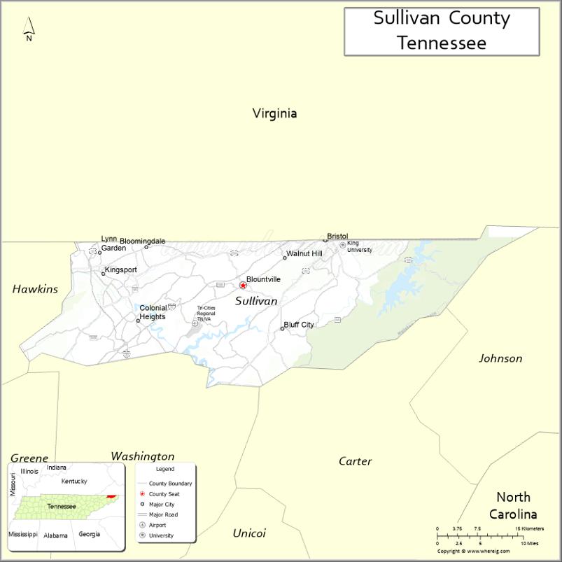
About Sullivan County Map, Tennessee: The map showing the county boundary, county seat, major cities, highways and neighbouring counties.
Tennessee More Maps & Info
About Sullivan County, Tennessee
Sullivan County is a county located in the U.S. state of Tennessee. It's county seat is Blountville. As per 2020 census, the population of Sullivan County is 159265 people and population density is square miles. According to the United States Census Bureau, the county has a total area of 413 sq mi (1,070 km2). Sullivan County was established on 1779.
Sullivan County Facts
| Continent | North America |
| Country | United States |
| State | Tennessee |
| County Seat | Blountville |
| Largest City/Town | Kingsport |
| Established | 1779 |
| Total Area | 430 sq mi |
| Land Area | 413 sq mi |
| Water Area | 17 sq mi |
| Population | 158,163 (Census 2020) |
| Population Density | 383 people per sq mi |
| Time Zone | Eastern (EST) |
| Major Highways | I-81, I-26, US-11W, US-19, US-421 |
| Neighboring Counties | Washington County, Hawkins County, Carter County, Scott County (VA), Washington County (VA) |
| Famous For | Bristol Motor Speedway, Tri-Cities region, Appalachian culture |
| Top Attractions | Bristol Motor Speedway, Warriors' Path State Park, Bays Mountain Park |
| Official Website | https://sullivancountytn.gov |
Cities and Towns in Sullivan County, Tennessee
- Blountville (county seat) – 3,074 (Census 2020)
- Kingsport – 55,442 (Census 2020)
- Bristol – 27,147 (Census 2020)
- Johnson City (partly) – 71,046 (Census 2020)
Roads and Highways in Sullivan County
Sullivan County is a key transportation hub in northeastern Tennessee with major highways connecting the Tri-Cities region and nearby states.
- Interstate 81 (I-81) – Runs northeast-southwest connecting the county to Virginia and Knoxville
- Interstate 26 (I-26) – Connects Kingsport and Johnson City to Asheville, NC
- U.S. Route 11W (US-11W) – Links local communities across the county
- U.S. Route 19 (US-19) – Connects Bristol to Kingsport and nearby areas
- U.S. Route 421 (US-421) – Connects Bristol to Mountain City and Boone, NC
Neighboring Counties of Sullivan County
- Washington County, TN (south)
- Hawkins County (west)
- Carter County (southeast)
- Scott County, VA (north)
- Washington County, VA (northeast)
Top Attractions in Sullivan County
Sullivan County offers a mix of motorsports, outdoor recreation, and scenic mountain views in the Tri-Cities area.
- Bristol Motor Speedway – Famous NASCAR track known as “The Last Great Colosseum”
- Warriors' Path State Park – Popular for hiking, boating, and camping
- Bays Mountain Park – Large nature preserve with trails and a planetarium
- South Holston Lake – Ideal for fishing, boating, and relaxing views
- Bristol Caverns – Underground cave tours with unique rock formations
- Kingsport Greenbelt – Scenic walking and biking trails
- Steele Creek Park – Large park with a lake and outdoor activities
Distance from Sullivan County to Nearby Cities
- Kingsport to Knoxville – 95 mi (153 km)
- Kingsport to Asheville – 75 mi (121 km)
- Kingsport to Roanoke – 140 mi (225 km)
- Kingsport to Nashville – 280 mi (451 km)
- Kingsport to Johnson City – 20 mi (32 km)
FAQs about Sullivan County
Sullivan County is known for Bristol Motor Speedway, Appalachian culture, and its role in the Tri-Cities region.
Blountville is the county seat of Sullivan County.
Kingsport is the largest city in the county.
Yes, it is part of the Tri-Cities region along with Washington and Carter counties.
The county offers parks, lakes, hiking trails, and scenic mountain views.
- Anderson County Map
- Bedford County Map
- Benton County Map
- Bledsoe County Map
- Blount County Map
- Bradley County Map
- Campbell County Map
- Cannon County Map
- Carroll County Map
- Carter County Map
- Cheatham County Map
- Chester County Map
- Claiborne County Map
- Clay County Map
- Cocke County Map
- Coffee County Map
- Crockett County Map
- Cumberland County Map
- Davidson County Map
- Decatur County Map
- DeKalb County Map
- Dickson County Map
- Dyer County Map
- Fayette County Map
- Fentress County Map
- Franklin County Map
- Gibson County Map
- Giles County Map
- Grainger County Map
- Greene County Map
- Grundy County Map
- Hamblen County Map
- Hamilton County Map
- Hancock County Map
- Hardeman County Map
- Hardin County Map
- Hawkins County Map
- Haywood County Map
- Henderson County Map
- Henry County Map
- Hickman County Map
- Houston County Map
- Humphreys County Map
- Jackson County Map
- Jefferson County Map
- Johnson County Map
- Knox County Map
- Lake County Map
- Lauderdale County Map
- Lawrence County Map
- Lewis County Map
- Lincoln County Map
- Loudon County Map
- McMinn County Map
- McNairy County Map
- Macon County Map
- Madison County Map
- Marion County Map
- Marshall County Map
- Maury County Map
- Meigs County Map
- Monroe County Map
- Montgomery County Map
- Moore County Map
- Morgan County Map
- Obion County Map
- Overton County Map
- Perry County Map
- Pickett County Map
- Polk County Map
- Putnam County Map
- Rhea County Map
- Roane County Map
- Robertson County Map
- Rutherford County Map
- Scott County Map
- Sequatchie County Map
- Sevier County Map
- Shelby County Map
- Smith County Map
- Stewart County Map
- Sullivan County Map
- Sumner County Map
- Tipton County Map
- Trousdale County Map
- Unicoi County Map
- Union County Map
- Van Buren County Map
- Warren County Map
- Washington County Map
- Wayne County Map
- Weakley County Map
- White County Map
- Williamson County Map
- Wilson County Map
- Alabama Counties
- Alaska boroughs
- Arizona Counties
- Arkansas Counties
- California County Map
- Colorado Counties
- Connecticut Counties
- Delaware Counties
- Florida County Map
- Georgia County Map
- Hawaii Counties
- Idaho Counties
- Illinois Counties
- Indiana Counties
- Iowa Counties
- Kansas Counties
- Kentucky Counties
- Louisiana Counties
- Maine Counties
- Maryland Counties
- Massachusetts Counties
- Michigan County Map
- Minnesota Counties
- Mississippi Counties
- Missouri Counties
- Montana Counties
- Nebraska Counties
- Nevada Counties
- New York Counties
- New Hampshire Counties
- New Jersey Counties
- New Mexico Counties
- North Carolina Counties
- North Dakota Counties
- Ohio County Map
- Oklahoma Counties
- Oregon Counties
- Pennsylvania Counties
- Rhode Island Counties
- South Carolina Counties
- South Dakota Counties
- Map of Tennessee
- Texas County Map
- Utah Counties
- Vermont Counties
- Virginia Counties
- Washington Counties
- West Virginia Counties
- Wisconsin Counties
- Wyoming Counties