Map of Unicoi County - Unicoi County is a county located in the U.S. state of Tennessee. Unicoi County Map showing cities, highways, important places and water bodies. Get Where is Unicoi County located in the map, major cities in Unicoi county, population, areas, and places of interest.
Map of Unicoi County, Tennessee
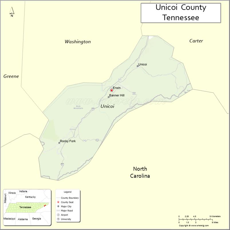
About Unicoi County Map, Tennessee: The map showing the county boundary, county seat, major cities, highways and neighbouring counties.
Tennessee More Maps & Info
About Unicoi County, Tennessee
Unicoi County is a county located in the U.S. state of Tennessee. It's county seat is Erwin. As per 2020 census, the population of Unicoi County is 17698 people and population density is square miles. According to the United States Census Bureau, the county has a total area of 186 sq mi (482 km2). Unicoi County was established on 1875.
Unicoi County Facts
| Continent | North America |
| Country | United States |
| State | Tennessee |
| County Seat | Erwin |
| Largest City/Town | Erwin |
| Established | 1875 |
| Total Area | 186 sq mi |
| Land Area | 186 sq mi |
| Water Area | 0.3 sq mi |
| Population | 17,928 (Census 2020) |
| Population Density | 96 people per sq mi |
| Time Zone | Eastern (EST) |
| Major Highways | I-26, US-19W, TN-107 |
| Neighboring Counties | Washington County, Carter County, Greene County, Mitchell County (NC), Yancey County (NC) |
| Famous For | Cherokee National Forest, Appalachian Mountains, outdoor recreation |
| Top Attractions | Buffalo Mountain Park, Nolichucky River, Cherokee National Forest |
| Official Website | https://unicoicountytn.gov |
Cities and Towns in Unicoi County, Tennessee
- Erwin (county seat) – 6,083 (Census 2020)
- Unicoi – 3,833 (Census 2020)
- Flag Pond – 0 (unincorporated community)
- Limestone Cove – 0 (unincorporated community)
Roads and Highways in Unicoi County
Unicoi County is connected by key highways that run through the Appalachian Mountains and link it to nearby cities and North Carolina.
- Interstate 26 (I-26) – Runs east-west connecting Erwin to Johnson City and Asheville, NC
- U.S. Route 19W (US-19W) – Connects the county to North Carolina and northern Tennessee
- Tennessee State Route 107 (TN-107) – Scenic route through mountain areas linking Erwin to Greene County
Neighboring Counties of Unicoi County
- Washington County (west)
- Carter County (north)
- Greene County (southwest)
- Mitchell County, NC (east)
- Yancey County, NC (southeast)
Top Attractions in Unicoi County
Unicoi County is known for its mountain scenery, outdoor recreation, and access to national forest lands.
- Cherokee National Forest – Offers hiking, camping, and scenic mountain views
- Nolichucky River – Popular for whitewater rafting and fishing
- Buffalo Mountain Park – Features trails and overlooks near the county line
- Rock Creek Recreation Area – Quiet spot for camping and picnicking
- Unaka Mountain Overlook – Scenic views of the Appalachian Mountains
- Erwin Linear Trail – Walking and biking trail along the river
- Beauty Spot – Famous high-elevation viewpoint with panoramic views
Distance from Unicoi County to Nearby Cities
- Erwin to Johnson City – 15 mi (24 km)
- Erwin to Asheville – 50 mi (80 km)
- Erwin to Knoxville – 110 mi (177 km)
- Erwin to Bristol – 40 mi (64 km)
- Erwin to Charlotte – 150 mi (241 km)
FAQs about Unicoi County
Unicoi County is known for the Cherokee National Forest, mountain scenery, and outdoor recreation.
Erwin is the county seat and largest town.
Yes, it borders North Carolina to the east.
Visitors can enjoy hiking, rafting, camping, and scenic drives in the mountains.
Yes, it is located within the Appalachian Mountains in northeastern Tennessee.
- Anderson County Map
- Bedford County Map
- Benton County Map
- Bledsoe County Map
- Blount County Map
- Bradley County Map
- Campbell County Map
- Cannon County Map
- Carroll County Map
- Carter County Map
- Cheatham County Map
- Chester County Map
- Claiborne County Map
- Clay County Map
- Cocke County Map
- Coffee County Map
- Crockett County Map
- Cumberland County Map
- Davidson County Map
- Decatur County Map
- DeKalb County Map
- Dickson County Map
- Dyer County Map
- Fayette County Map
- Fentress County Map
- Franklin County Map
- Gibson County Map
- Giles County Map
- Grainger County Map
- Greene County Map
- Grundy County Map
- Hamblen County Map
- Hamilton County Map
- Hancock County Map
- Hardeman County Map
- Hardin County Map
- Hawkins County Map
- Haywood County Map
- Henderson County Map
- Henry County Map
- Hickman County Map
- Houston County Map
- Humphreys County Map
- Jackson County Map
- Jefferson County Map
- Johnson County Map
- Knox County Map
- Lake County Map
- Lauderdale County Map
- Lawrence County Map
- Lewis County Map
- Lincoln County Map
- Loudon County Map
- McMinn County Map
- McNairy County Map
- Macon County Map
- Madison County Map
- Marion County Map
- Marshall County Map
- Maury County Map
- Meigs County Map
- Monroe County Map
- Montgomery County Map
- Moore County Map
- Morgan County Map
- Obion County Map
- Overton County Map
- Perry County Map
- Pickett County Map
- Polk County Map
- Putnam County Map
- Rhea County Map
- Roane County Map
- Robertson County Map
- Rutherford County Map
- Scott County Map
- Sequatchie County Map
- Sevier County Map
- Shelby County Map
- Smith County Map
- Stewart County Map
- Sullivan County Map
- Sumner County Map
- Tipton County Map
- Trousdale County Map
- Unicoi County Map
- Union County Map
- Van Buren County Map
- Warren County Map
- Washington County Map
- Wayne County Map
- Weakley County Map
- White County Map
- Williamson County Map
- Wilson County Map
- Alabama Counties
- Alaska boroughs
- Arizona Counties
- Arkansas Counties
- California County Map
- Colorado Counties
- Connecticut Counties
- Delaware Counties
- Florida County Map
- Georgia County Map
- Hawaii Counties
- Idaho Counties
- Illinois Counties
- Indiana Counties
- Iowa Counties
- Kansas Counties
- Kentucky Counties
- Louisiana Counties
- Maine Counties
- Maryland Counties
- Massachusetts Counties
- Michigan County Map
- Minnesota Counties
- Mississippi Counties
- Missouri Counties
- Montana Counties
- Nebraska Counties
- Nevada Counties
- New York Counties
- New Hampshire Counties
- New Jersey Counties
- New Mexico Counties
- North Carolina Counties
- North Dakota Counties
- Ohio County Map
- Oklahoma Counties
- Oregon Counties
- Pennsylvania Counties
- Rhode Island Counties
- South Carolina Counties
- South Dakota Counties
- Map of Tennessee
- Texas County Map
- Utah Counties
- Vermont Counties
- Virginia Counties
- Washington Counties
- West Virginia Counties
- Wisconsin Counties
- Wyoming Counties