Map of Trousdale County - Trousdale County is a county located in the U.S. state of Tennessee. Trousdale County Map showing cities, highways, important places and water bodies. Get Where is Trousdale County located in the map, major cities in Trousdale county, population, areas, and places of interest.
Map of Trousdale County, Tennessee
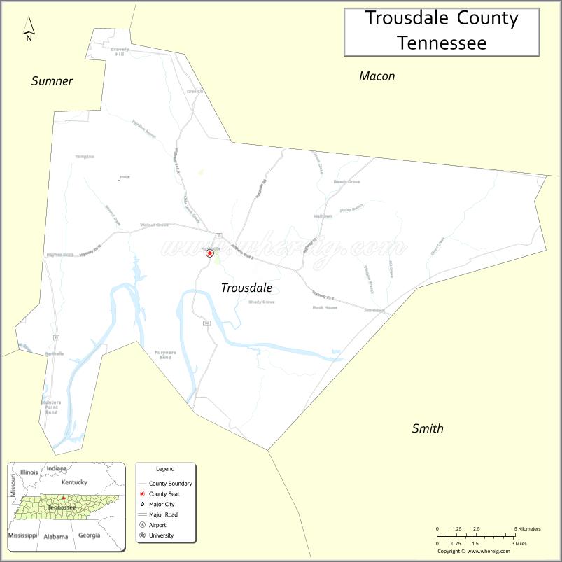
About Trousdale County Map, Tennessee: The map showing the county boundary, county seat, major cities, highways and neighbouring counties.
Tennessee More Maps & Info
About Trousdale County, Tennessee
Trousdale County is a county located in the U.S. state of Tennessee. It's county seat is Hartsville. As per 2020 census, the population of Trousdale County is 12035 people and population density is square miles. According to the United States Census Bureau, the county has a total area of 114 sq mi (295 km2). Trousdale County was established on 1870.
Trousdale County Facts
| Continent | North America |
| Country | United States |
| State | Tennessee |
| County Seat | Hartsville |
| Largest City/Town | Hartsville |
| Established | 1870 |
| Total Area | 114 sq mi |
| Land Area | 112 sq mi |
| Water Area | 2 sq mi |
| Population | 11,615 (Census 2020) |
| Population Density | 104 people per sq mi |
| Time Zone | Central (CST) |
| Major Highways | TN-10, TN-25, TN-141 |
| Neighboring Counties | Sumner County, Macon County, Smith County, Wilson County |
| Famous For | Small size, Cumberland River, rural setting |
| Top Attractions | Hartsville Historic District, Trousdale County Courthouse, Cumberland River |
| Official Website | https://trousdalecountytn.gov |
Cities and Towns in Trousdale County, Tennessee
- Hartsville (county seat) – 2,658 (Census 2020)
- Castalian Springs – 1,000 (approx. community)
- Dixon Springs – 500 (approx. community)
- New Harmony – 0 (unincorporated community)
Roads and Highways in Trousdale County
Trousdale County is served by several state highways that connect it to nearby counties and small towns in Middle Tennessee.
- Tennessee State Route 10 (TN-10) – Runs north-south connecting Hartsville to Lebanon and Lafayette
- Tennessee State Route 25 (TN-25) – East-west route linking Hartsville to Carthage and Gallatin
- Tennessee State Route 141 (TN-141) – Connects the county to Gordonsville and surrounding rural areas
Neighboring Counties of Trousdale County
- Sumner County (west)
- Macon County (north)
- Smith County (east)
- Wilson County (south)
Top Attractions in Trousdale County
Trousdale County offers a quiet rural atmosphere with historic sites and scenic river views.
- Hartsville Historic District – Small-town area with historic buildings
- Trousdale County Courthouse – Historic courthouse in the center of town
- Cumberland River – Offers fishing, boating, and scenic views
- Hartsville City Park – Local park with open spaces and recreation areas
- Old Trousdale County Jail – Historic landmark with local significance
- Rural Scenic Drives – Peaceful countryside routes with farmland views
- Community Events – Local fairs and gatherings throughout the year
Distance from Trousdale County to Nearby Cities
- Hartsville to Nashville – 50 mi (80 km)
- Hartsville to Gallatin – 25 mi (40 km)
- Hartsville to Lebanon – 30 mi (48 km)
- Hartsville to Cookeville – 60 mi (97 km)
- Hartsville to Knoxville – 160 mi (257 km)
FAQs about Trousdale County
Trousdale County is known for its small size, rural setting, and the Cumberland River.
Hartsville is the county seat and largest town.
Yes, it is one of the smallest counties in the state by area.
Yes, it is about 50 miles northeast of Nashville.
Visitors can enjoy fishing, boating, and exploring scenic countryside areas.
- Anderson County Map
- Bedford County Map
- Benton County Map
- Bledsoe County Map
- Blount County Map
- Bradley County Map
- Campbell County Map
- Cannon County Map
- Carroll County Map
- Carter County Map
- Cheatham County Map
- Chester County Map
- Claiborne County Map
- Clay County Map
- Cocke County Map
- Coffee County Map
- Crockett County Map
- Cumberland County Map
- Davidson County Map
- Decatur County Map
- DeKalb County Map
- Dickson County Map
- Dyer County Map
- Fayette County Map
- Fentress County Map
- Franklin County Map
- Gibson County Map
- Giles County Map
- Grainger County Map
- Greene County Map
- Grundy County Map
- Hamblen County Map
- Hamilton County Map
- Hancock County Map
- Hardeman County Map
- Hardin County Map
- Hawkins County Map
- Haywood County Map
- Henderson County Map
- Henry County Map
- Hickman County Map
- Houston County Map
- Humphreys County Map
- Jackson County Map
- Jefferson County Map
- Johnson County Map
- Knox County Map
- Lake County Map
- Lauderdale County Map
- Lawrence County Map
- Lewis County Map
- Lincoln County Map
- Loudon County Map
- McMinn County Map
- McNairy County Map
- Macon County Map
- Madison County Map
- Marion County Map
- Marshall County Map
- Maury County Map
- Meigs County Map
- Monroe County Map
- Montgomery County Map
- Moore County Map
- Morgan County Map
- Obion County Map
- Overton County Map
- Perry County Map
- Pickett County Map
- Polk County Map
- Putnam County Map
- Rhea County Map
- Roane County Map
- Robertson County Map
- Rutherford County Map
- Scott County Map
- Sequatchie County Map
- Sevier County Map
- Shelby County Map
- Smith County Map
- Stewart County Map
- Sullivan County Map
- Sumner County Map
- Tipton County Map
- Trousdale County Map
- Unicoi County Map
- Union County Map
- Van Buren County Map
- Warren County Map
- Washington County Map
- Wayne County Map
- Weakley County Map
- White County Map
- Williamson County Map
- Wilson County Map
- Alabama Counties
- Alaska boroughs
- Arizona Counties
- Arkansas Counties
- California County Map
- Colorado Counties
- Connecticut Counties
- Delaware Counties
- Florida County Map
- Georgia County Map
- Hawaii Counties
- Idaho Counties
- Illinois Counties
- Indiana Counties
- Iowa Counties
- Kansas Counties
- Kentucky Counties
- Louisiana Counties
- Maine Counties
- Maryland Counties
- Massachusetts Counties
- Michigan County Map
- Minnesota Counties
- Mississippi Counties
- Missouri Counties
- Montana Counties
- Nebraska Counties
- Nevada Counties
- New York Counties
- New Hampshire Counties
- New Jersey Counties
- New Mexico Counties
- North Carolina Counties
- North Dakota Counties
- Ohio County Map
- Oklahoma Counties
- Oregon Counties
- Pennsylvania Counties
- Rhode Island Counties
- South Carolina Counties
- South Dakota Counties
- Map of Tennessee
- Texas County Map
- Utah Counties
- Vermont Counties
- Virginia Counties
- Washington Counties
- West Virginia Counties
- Wisconsin Counties
- Wyoming Counties