Map of Shelby County - Shelby County is a county located in the U.S. state of Tennessee. Shelby County Map showing cities, highways, important places and water bodies. Get Where is Shelby County located in the map, major cities in Shelby county, population, areas, and places of interest.
Map of Shelby County, Tennessee
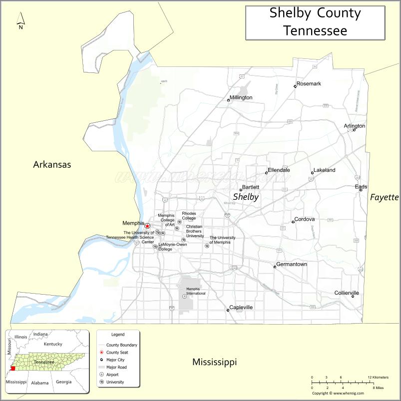
About Shelby County Map, Tennessee: The map showing the county boundary, county seat, major cities, highways and neighbouring counties.
Tennessee More Maps & Info
About Shelby County, Tennessee
Shelby County is a county located in the U.S. state of Tennessee. It's county seat is Memphis. As per 2020 census, the population of Shelby County is 924454 people and population density is square miles. According to the United States Census Bureau, the county has a total area of 755 sq mi (1,955 km2). Shelby County was established on 1819.
Shelby County Facts
| Continent | North America |
| Country | United States |
| State | Tennessee |
| County Seat | Memphis |
| Largest City/Town | Memphis |
| Established | 1819 |
| Total Area | 785 sq mi |
| Land Area | 763 sq mi |
| Water Area | 22 sq mi |
| Population | 929,744 (Census 2020) |
| Population Density | 1,219 people per sq mi |
| Time Zone | Central (CST) |
| Major Highways | I-40, I-55, I-240, US-51, US-64, US-72 |
| Neighboring Counties | Tipton County, Fayette County, DeSoto County (MS), Marshall County (MS), Crittenden County (AR) |
| Famous For | Memphis music, blues, Elvis Presley, Mississippi River |
| Top Attractions | Graceland, Beale Street, Memphis Zoo |
| Official Website | https://www.shelbycountytn.gov |
Cities and Towns in Shelby County, Tennessee
- Memphis (county seat) – 633,104 (Census 2020)
- Collierville – 51,324 (Census 2020)
- Germantown – 41,333 (Census 2020)
- Bartlett – 57,786 (Census 2020)
Roads and Highways in Shelby County
Shelby County is a major transportation hub in the Mid-South, with highways connecting Memphis to neighboring states and major U.S. cities.
- Interstate 40 (I-40) – Runs east-west connecting Memphis to Nashville and Little Rock
- Interstate 55 (I-55) – North-south route linking Memphis to St. Louis and Jackson, MS
- Interstate 240 (I-240) – Loop around Memphis connecting major city routes
- U.S. Route 51 (US-51) – Connects Memphis to Mississippi and northern Tennessee
- U.S. Route 64 (US-64) – East-west route connecting Memphis to Chattanooga
- U.S. Route 72 (US-72) – Connects Memphis to Alabama and Mississippi
Neighboring Counties of Shelby County
- Tipton County (north)
- Fayette County (east)
- Marshall County, MS (southeast)
- DeSoto County, MS (south)
- Crittenden County, AR (west)
Top Attractions in Shelby County
Shelby County is rich in culture, music history, and entertainment, centered around the city of Memphis.
- Graceland – Home of Elvis Presley and one of the most visited music landmarks
- Beale Street – Famous for live blues music, restaurants, and nightlife
- Memphis Zoo – One of the top-rated zoos in the United States
- National Civil Rights Museum – Historic site at the Lorraine Motel
- Sun Studio – Legendary recording studio for early rock and roll
- Mississippi Riverfront – Scenic area with parks and river views
- Shelby Farms Park – Large urban park with trails, lakes, and outdoor activities
Distance from Shelby County to Nearby Cities
- Memphis to Nashville – 212 mi (341 km)
- Memphis to Little Rock – 135 mi (217 km)
- Memphis to Jackson, MS – 210 mi (338 km)
- Memphis to St. Louis – 284 mi (457 km)
- Memphis to Birmingham – 240 mi (386 km)
FAQs about Shelby County
Shelby County is known for Memphis music, blues culture, and landmarks like Graceland.
Memphis is the county seat and largest city.
The Mississippi River runs along the western edge of the county.
Yes, Shelby County has the largest population in Tennessee.
Interstates 40, 55, and 240 are the main highways in the county.
- Anderson County Map
- Bedford County Map
- Benton County Map
- Bledsoe County Map
- Blount County Map
- Bradley County Map
- Campbell County Map
- Cannon County Map
- Carroll County Map
- Carter County Map
- Cheatham County Map
- Chester County Map
- Claiborne County Map
- Clay County Map
- Cocke County Map
- Coffee County Map
- Crockett County Map
- Cumberland County Map
- Davidson County Map
- Decatur County Map
- DeKalb County Map
- Dickson County Map
- Dyer County Map
- Fayette County Map
- Fentress County Map
- Franklin County Map
- Gibson County Map
- Giles County Map
- Grainger County Map
- Greene County Map
- Grundy County Map
- Hamblen County Map
- Hamilton County Map
- Hancock County Map
- Hardeman County Map
- Hardin County Map
- Hawkins County Map
- Haywood County Map
- Henderson County Map
- Henry County Map
- Hickman County Map
- Houston County Map
- Humphreys County Map
- Jackson County Map
- Jefferson County Map
- Johnson County Map
- Knox County Map
- Lake County Map
- Lauderdale County Map
- Lawrence County Map
- Lewis County Map
- Lincoln County Map
- Loudon County Map
- McMinn County Map
- McNairy County Map
- Macon County Map
- Madison County Map
- Marion County Map
- Marshall County Map
- Maury County Map
- Meigs County Map
- Monroe County Map
- Montgomery County Map
- Moore County Map
- Morgan County Map
- Obion County Map
- Overton County Map
- Perry County Map
- Pickett County Map
- Polk County Map
- Putnam County Map
- Rhea County Map
- Roane County Map
- Robertson County Map
- Rutherford County Map
- Scott County Map
- Sequatchie County Map
- Sevier County Map
- Shelby County Map
- Smith County Map
- Stewart County Map
- Sullivan County Map
- Sumner County Map
- Tipton County Map
- Trousdale County Map
- Unicoi County Map
- Union County Map
- Van Buren County Map
- Warren County Map
- Washington County Map
- Wayne County Map
- Weakley County Map
- White County Map
- Williamson County Map
- Wilson County Map
- Alabama Counties
- Alaska boroughs
- Arizona Counties
- Arkansas Counties
- California County Map
- Colorado Counties
- Connecticut Counties
- Delaware Counties
- Florida County Map
- Georgia County Map
- Hawaii Counties
- Idaho Counties
- Illinois Counties
- Indiana Counties
- Iowa Counties
- Kansas Counties
- Kentucky Counties
- Louisiana Counties
- Maine Counties
- Maryland Counties
- Massachusetts Counties
- Michigan County Map
- Minnesota Counties
- Mississippi Counties
- Missouri Counties
- Montana Counties
- Nebraska Counties
- Nevada Counties
- New York Counties
- New Hampshire Counties
- New Jersey Counties
- New Mexico Counties
- North Carolina Counties
- North Dakota Counties
- Ohio County Map
- Oklahoma Counties
- Oregon Counties
- Pennsylvania Counties
- Rhode Island Counties
- South Carolina Counties
- South Dakota Counties
- Map of Tennessee
- Texas County Map
- Utah Counties
- Vermont Counties
- Virginia Counties
- Washington Counties
- West Virginia Counties
- Wisconsin Counties
- Wyoming Counties