Map of Wilson County - Wilson County is a county located in the U.S. state of Tennessee. Wilson County Map showing cities, highways, important places and water bodies. Get Where is Wilson County located in the map, major cities in Wilson county, population, areas, and places of interest.
Map of Wilson County, Tennessee
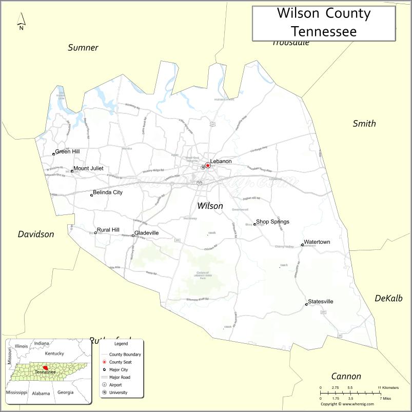
About Wilson County Map, Tennessee: The map showing the county boundary, county seat, major cities, highways and neighbouring counties.
Tennessee More Maps & Info
About Wilson County, Tennessee
Wilson County is a county located in the U.S. state of Tennessee. It's county seat is Lebanon. As per 2020 census, the population of Wilson County is 151917 people and population density is square miles. According to the United States Census Bureau, the county has a total area of 571 sq mi (1,479 km2). Wilson County was established on 1799.
Wilson County Facts
| Continent | North America |
| Country | United States |
| State | Tennessee |
| County Seat | Lebanon |
| Largest City/Town | Lebanon |
| Established | 1799 |
| Total Area | 583 sq mi |
| Land Area | 571 sq mi |
| Water Area | 12 sq mi |
| Population | 147,737 (Census 2020) |
| Population Density | 259 people per sq mi |
| Time Zone | Central (CST) |
| Major Highways | I-40, I-840, US-70, US-231, TN-109 |
| Neighboring Counties | Sumner County, Trousdale County, Smith County, DeKalb County, Cannon County, Rutherford County, Davidson County |
| Famous For | Cedar of Lebanon State Park, proximity to Nashville, historic sites |
| Top Attractions | Cedar of Lebanon State Park, Fiddlers Grove Historic Village, Lebanon Square |
| Official Website | https://www.wilsoncountytn.gov |
Cities and Towns in Wilson County, Tennessee
- Lebanon (county seat) – 38,603 (Census 2020)
- Mt. Juliet – 39,289 (Census 2020)
- Watertown – 1,611 (Census 2020)
- Green Hill – 6,618 (Census 2020)
Roads and Highways in Wilson County
Wilson County has a strong transportation network that connects it directly to Nashville and surrounding areas in Middle Tennessee.
- Interstate 40 (I-40) – Runs east-west connecting Lebanon to Nashville and Knoxville
- Interstate 840 (I-840) – Bypass route linking outer suburban areas around Nashville
- U.S. Route 70 (US-70) – Connects Lebanon to Nashville and eastern Tennessee
- U.S. Route 231 (US-231) – Runs north-south linking the county to Kentucky and southern Tennessee
- Tennessee State Route 109 (TN-109) – Connects Mt. Juliet to Gallatin and Murfreesboro
Neighboring Counties of Wilson County
- Sumner County (north)
- Trousdale County (northeast)
- Smith County (east)
- DeKalb County (southeast)
- Cannon County (south)
- Rutherford County (southwest)
- Davidson County (west)
Top Attractions in Wilson County
Wilson County offers a mix of parks, history, and suburban attractions close to Nashville.
- Cedar of Lebanon State Park – Known for cedar forests, hiking trails, and camping
- Fiddlers Grove Historic Village – Open-air museum showcasing 19th-century life
- Lebanon Square – Historic downtown area with shops and dining
- Sellars Farm State Archaeological Area – Site with Native American history and trails
- Mt. Juliet Parks – Local parks with sports facilities and walking paths
- Don Fox Community Park – Family-friendly park in Lebanon
- Old Hickory Lake (nearby) – Popular for boating and fishing
Distance from Wilson County to Nearby Cities
- Lebanon to Nashville – 30 mi (48 km)
- Lebanon to Murfreesboro – 30 mi (48 km)
- Lebanon to Knoxville – 150 mi (241 km)
- Lebanon to Chattanooga – 120 mi (193 km)
- Lebanon to Cookeville – 45 mi (72 km)
FAQs about Wilson County
Wilson County is known for Cedar of Lebanon State Park, historic sites, and its proximity to Nashville.
Lebanon is the county seat and largest city.
Yes, it is located just east of Nashville.
Visitors can enjoy parks, lakes, hiking trails, and outdoor recreation areas.
Yes, it is one of the fast-growing counties in the Nashville metropolitan area.
- Anderson County Map
- Bedford County Map
- Benton County Map
- Bledsoe County Map
- Blount County Map
- Bradley County Map
- Campbell County Map
- Cannon County Map
- Carroll County Map
- Carter County Map
- Cheatham County Map
- Chester County Map
- Claiborne County Map
- Clay County Map
- Cocke County Map
- Coffee County Map
- Crockett County Map
- Cumberland County Map
- Davidson County Map
- Decatur County Map
- DeKalb County Map
- Dickson County Map
- Dyer County Map
- Fayette County Map
- Fentress County Map
- Franklin County Map
- Gibson County Map
- Giles County Map
- Grainger County Map
- Greene County Map
- Grundy County Map
- Hamblen County Map
- Hamilton County Map
- Hancock County Map
- Hardeman County Map
- Hardin County Map
- Hawkins County Map
- Haywood County Map
- Henderson County Map
- Henry County Map
- Hickman County Map
- Houston County Map
- Humphreys County Map
- Jackson County Map
- Jefferson County Map
- Johnson County Map
- Knox County Map
- Lake County Map
- Lauderdale County Map
- Lawrence County Map
- Lewis County Map
- Lincoln County Map
- Loudon County Map
- McMinn County Map
- McNairy County Map
- Macon County Map
- Madison County Map
- Marion County Map
- Marshall County Map
- Maury County Map
- Meigs County Map
- Monroe County Map
- Montgomery County Map
- Moore County Map
- Morgan County Map
- Obion County Map
- Overton County Map
- Perry County Map
- Pickett County Map
- Polk County Map
- Putnam County Map
- Rhea County Map
- Roane County Map
- Robertson County Map
- Rutherford County Map
- Scott County Map
- Sequatchie County Map
- Sevier County Map
- Shelby County Map
- Smith County Map
- Stewart County Map
- Sullivan County Map
- Sumner County Map
- Tipton County Map
- Trousdale County Map
- Unicoi County Map
- Union County Map
- Van Buren County Map
- Warren County Map
- Washington County Map
- Wayne County Map
- Weakley County Map
- White County Map
- Williamson County Map
- Wilson County Map
- Alabama Counties
- Alaska boroughs
- Arizona Counties
- Arkansas Counties
- California County Map
- Colorado Counties
- Connecticut Counties
- Delaware Counties
- Florida County Map
- Georgia County Map
- Hawaii Counties
- Idaho Counties
- Illinois Counties
- Indiana Counties
- Iowa Counties
- Kansas Counties
- Kentucky Counties
- Louisiana Counties
- Maine Counties
- Maryland Counties
- Massachusetts Counties
- Michigan County Map
- Minnesota Counties
- Mississippi Counties
- Missouri Counties
- Montana Counties
- Nebraska Counties
- Nevada Counties
- New York Counties
- New Hampshire Counties
- New Jersey Counties
- New Mexico Counties
- North Carolina Counties
- North Dakota Counties
- Ohio County Map
- Oklahoma Counties
- Oregon Counties
- Pennsylvania Counties
- Rhode Island Counties
- South Carolina Counties
- South Dakota Counties
- Map of Tennessee
- Texas County Map
- Utah Counties
- Vermont Counties
- Virginia Counties
- Washington Counties
- West Virginia Counties
- Wisconsin Counties
- Wyoming Counties