Map of Giles County - Giles County is a county located in the U.S. state of Tennessee. Giles County Map showing cities, highways, important places and water bodies. Get Where is Giles County located in the map, major cities in Giles county, population, areas, and places of interest.
Map of Giles County, Tennessee
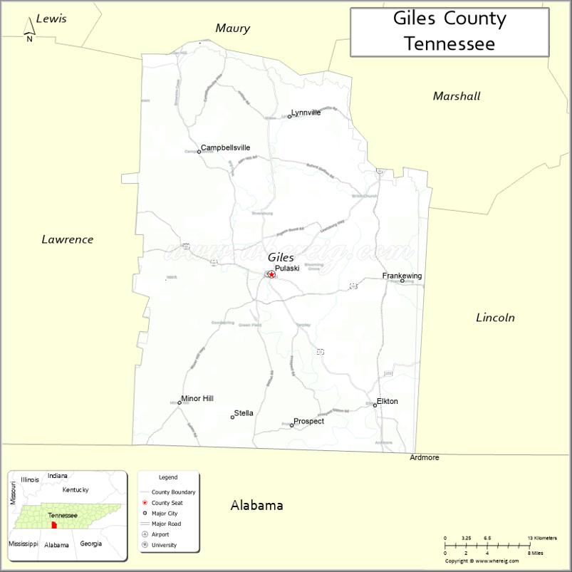
About Giles County Map, Tennessee: The map showing the county boundary, county seat, major cities, highways and neighbouring counties.
Tennessee More Maps & Info
About Giles County, Tennessee
Giles County is a county located in the U.S. state of Tennessee. It's county seat is Pulaski. As per 2020 census, the population of Giles County is 30542 people and population density is square miles. According to the United States Census Bureau, the county has a total area of 611 sq mi (1,582 km2). Giles County was established on 1809.
Giles County Facts
| Continent | North America |
| Country | United States |
| State | Tennessee |
| County Seat | Pulaski |
| Largest City/Town | Pulaski |
| Established | 1809 |
| Total Area | 611 sq mi (1,583 sq km) |
| Land Area | 611 sq mi (1,583 sq km) |
| Water Area | 0.9 sq mi (2 sq km) |
| Population | 29,653 (Census 2020) |
| Population Density | 49 people per sq mi |
| Time Zone | Central Time Zone (CT) |
| Major Highways | US-31, US-64, TN-11, TN-13 |
| Neighboring Counties | Marshall County, Maury County, Lawrence County, Lincoln County, Limestone County (AL) |
| Famous For | Historic Pulaski, agriculture, rolling countryside |
| Top Attractions | Milky Way Farm, Trail of Tears Memorial, Big Creek Winery |
| Official Website | https://www.gilescountytn.gov |
Cities and Towns in Giles County, Tennessee
- Pulaski (county seat) – 7,871 (Census 2020)
- Lynnville – 327 (Census 2020)
- Minor Hill – 541 (Census 2020)
- Ardmore (partly) – 1,200 (Census 2020)
Roads and Highways in Giles County
Giles County is served by major highways that connect it to nearby cities in southern Tennessee and northern Alabama.
- U.S. Route 31 – runs north–south, connecting Pulaski to Columbia and Alabama
- U.S. Route 64 – runs east–west, linking Giles County to Lawrenceburg and Fayetteville
- State Route 11 – parallels US-31 and connects local communities
- State Route 13 – connects rural areas and nearby counties
Neighboring Counties of Giles County
- Maury County (north)
- Marshall County (northeast)
- Lincoln County (east)
- Lawrence County (west)
- Limestone County, Alabama (south)
Top Attractions in Giles County
Giles County offers historic sites, scenic countryside, and local attractions.
- Milky Way Farm – a historic estate once owned by a Mars candy executive
- Trail of Tears Memorial – honors the history of Native American relocation
- Big Creek Winery – offers local wines and tastings
- Pulaski Historic Downtown – features shops, restaurants, and historic buildings
- Soda Pop Junction – a nostalgic spot for classic treats
- Giles County Courthouse – a historic landmark in Pulaski
- Richland Creek – provides opportunities for fishing and outdoor relaxation
Distance from Giles County to Nearby Cities
- Giles County to Nashville – 75 mi (121 km)
- Giles County to Huntsville – 35 mi (56 km)
- Giles County to Chattanooga – 120 mi (193 km)
- Giles County to Birmingham – 120 mi (193 km)
- Giles County to Memphis – 200 mi (322 km)
FAQs about Giles County
Giles County is located in southern Tennessee along the Alabama border.
The county seat is Pulaski.
It is known for its historic sites, agriculture, and scenic countryside.
Main attractions include Milky Way Farm, the Trail of Tears Memorial, and Pulaski’s historic downtown.
You can reach Giles County via U.S. Routes 31 and 64.
- Anderson County Map
- Bedford County Map
- Benton County Map
- Bledsoe County Map
- Blount County Map
- Bradley County Map
- Campbell County Map
- Cannon County Map
- Carroll County Map
- Carter County Map
- Cheatham County Map
- Chester County Map
- Claiborne County Map
- Clay County Map
- Cocke County Map
- Coffee County Map
- Crockett County Map
- Cumberland County Map
- Davidson County Map
- Decatur County Map
- DeKalb County Map
- Dickson County Map
- Dyer County Map
- Fayette County Map
- Fentress County Map
- Franklin County Map
- Gibson County Map
- Giles County Map
- Grainger County Map
- Greene County Map
- Grundy County Map
- Hamblen County Map
- Hamilton County Map
- Hancock County Map
- Hardeman County Map
- Hardin County Map
- Hawkins County Map
- Haywood County Map
- Henderson County Map
- Henry County Map
- Hickman County Map
- Houston County Map
- Humphreys County Map
- Jackson County Map
- Jefferson County Map
- Johnson County Map
- Knox County Map
- Lake County Map
- Lauderdale County Map
- Lawrence County Map
- Lewis County Map
- Lincoln County Map
- Loudon County Map
- McMinn County Map
- McNairy County Map
- Macon County Map
- Madison County Map
- Marion County Map
- Marshall County Map
- Maury County Map
- Meigs County Map
- Monroe County Map
- Montgomery County Map
- Moore County Map
- Morgan County Map
- Obion County Map
- Overton County Map
- Perry County Map
- Pickett County Map
- Polk County Map
- Putnam County Map
- Rhea County Map
- Roane County Map
- Robertson County Map
- Rutherford County Map
- Scott County Map
- Sequatchie County Map
- Sevier County Map
- Shelby County Map
- Smith County Map
- Stewart County Map
- Sullivan County Map
- Sumner County Map
- Tipton County Map
- Trousdale County Map
- Unicoi County Map
- Union County Map
- Van Buren County Map
- Warren County Map
- Washington County Map
- Wayne County Map
- Weakley County Map
- White County Map
- Williamson County Map
- Wilson County Map
- Alabama Counties
- Alaska boroughs
- Arizona Counties
- Arkansas Counties
- California County Map
- Colorado Counties
- Connecticut Counties
- Delaware Counties
- Florida County Map
- Georgia County Map
- Hawaii Counties
- Idaho Counties
- Illinois Counties
- Indiana Counties
- Iowa Counties
- Kansas Counties
- Kentucky Counties
- Louisiana Counties
- Maine Counties
- Maryland Counties
- Massachusetts Counties
- Michigan County Map
- Minnesota Counties
- Mississippi Counties
- Missouri Counties
- Montana Counties
- Nebraska Counties
- Nevada Counties
- New York Counties
- New Hampshire Counties
- New Jersey Counties
- New Mexico Counties
- North Carolina Counties
- North Dakota Counties
- Ohio County Map
- Oklahoma Counties
- Oregon Counties
- Pennsylvania Counties
- Rhode Island Counties
- South Carolina Counties
- South Dakota Counties
- Map of Tennessee
- Texas County Map
- Utah Counties
- Vermont Counties
- Virginia Counties
- Washington Counties
- West Virginia Counties
- Wisconsin Counties
- Wyoming Counties