Map of Williamson County - Williamson County is a county located in the U.S. state of Tennessee. Williamson County Map showing cities, highways, important places and water bodies. Get Where is Williamson County located in the map, major cities in Williamson county, population, areas, and places of interest.
Map of Williamson County, Tennessee
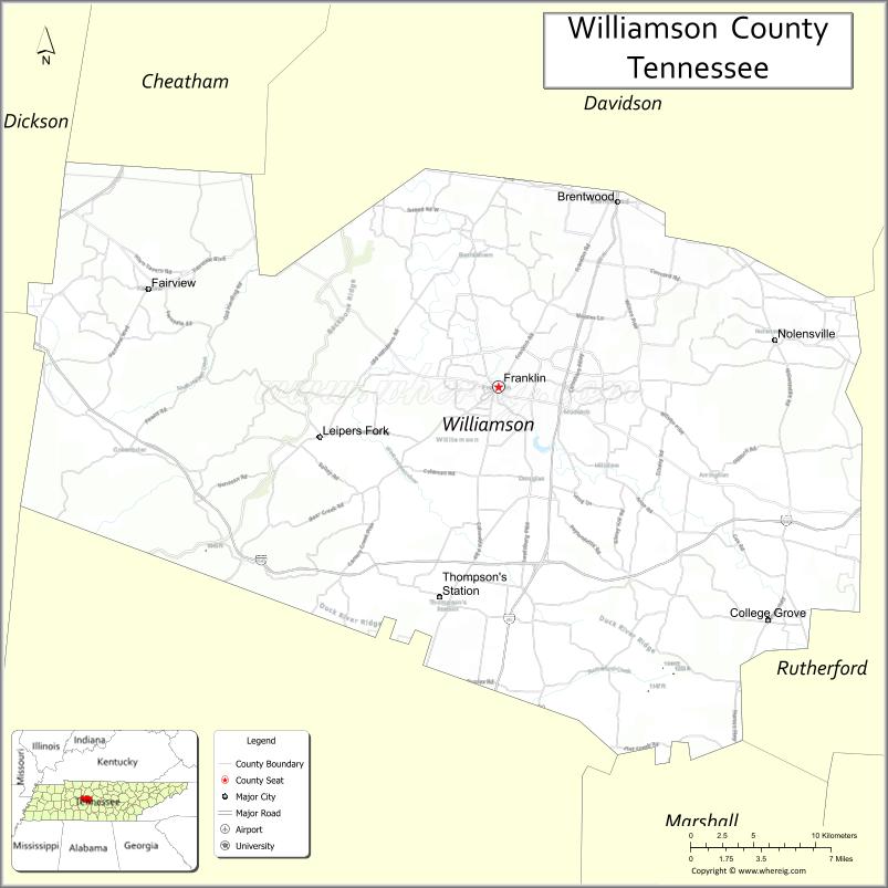
About Williamson County Map, Tennessee: The map showing the county boundary, county seat, major cities, highways and neighbouring counties.
Tennessee More Maps & Info
About Williamson County, Tennessee
Williamson County is a county located in the U.S. state of Tennessee. It's county seat is Franklin. As per 2020 census, the population of Williamson County is 255735 people and population density is square miles. According to the United States Census Bureau, the county has a total area of 582 sq mi (1,507 km2). Williamson County was established on 1799.
Williamson County Facts
| Continent | North America |
| Country | United States |
| State | Tennessee |
| County Seat | Franklin |
| Largest City/Town | Franklin |
| Established | 1799 |
| Total Area | 584 sq mi |
| Land Area | 582 sq mi |
| Water Area | 2 sq mi |
| Population | 247,726 (Census 2020) |
| Population Density | 425 people per sq mi |
| Time Zone | Central (CST) |
| Major Highways | I-65, I-840, US-31, US-431, TN-96 |
| Neighboring Counties | Davidson County, Wilson County, Rutherford County, Maury County, Hickman County, Marshall County |
| Famous For | Historic Franklin, Civil War sites, affluent suburbs |
| Top Attractions | Franklin Historic District, Carnton Plantation, Natchez Trace Parkway |
| Official Website | https://www.williamsoncounty-tn.gov |
Cities and Towns in Williamson County, Tennessee
- Franklin (county seat) – 83,454 (Census 2020)
- Brentwood – 44,706 (Census 2020)
- Nolensville – 14,721 (Census 2020)
- Spring Hill (partly) – 50,005 (Census 2020)
Roads and Highways in Williamson County
Williamson County is well connected by major highways that link it directly to Nashville and other parts of Middle Tennessee.
- Interstate 65 (I-65) – Runs north-south connecting Franklin to Nashville and Alabama
- Interstate 840 (I-840) – Bypass route connecting outer suburbs around Nashville
- U.S. Route 31 (US-31) – Connects Franklin to Nashville and southern Tennessee
- U.S. Route 431 (US-431) – Links the county to Columbia and northern Tennessee
- Tennessee State Route 96 (TN-96) – Connects Franklin to Murfreesboro
Neighboring Counties of Williamson County
- Davidson County (north)
- Wilson County (northeast)
- Rutherford County (east)
- Maury County (south)
- Marshall County (southwest)
- Hickman County (west)
Top Attractions in Williamson County
Williamson County is known for its historic sites, scenic drives, and upscale suburban communities near Nashville.
- Franklin Historic District – Charming downtown with shops, restaurants, and historic buildings
- Carnton Plantation – Civil War site with guided tours and history exhibits
- Natchez Trace Parkway – Scenic drive with trails and overlooks
- Arrington Vineyards – Popular winery with beautiful countryside views
- Harlinsdale Farm – Historic farm with walking trails and events
- Pinkerton Park – Family-friendly park in Franklin
- Brentwood Greenway – Network of trails for walking and biking
Distance from Williamson County to Nearby Cities
- Franklin to Nashville – 20 mi (32 km)
- Franklin to Murfreesboro – 30 mi (48 km)
- Franklin to Columbia – 30 mi (48 km)
- Franklin to Chattanooga – 120 mi (193 km)
- Franklin to Knoxville – 180 mi (290 km)
FAQs about Williamson County
Williamson County is known for its historic sites, Civil War history, and upscale suburban communities.
Franklin is the county seat and largest city.
Yes, it is located just south of Nashville.
Visitors enjoy historic sites, scenic drives, parks, and local wineries.
Yes, it is one of the fastest-growing and wealthiest counties in Tennessee.
- Anderson County Map
- Bedford County Map
- Benton County Map
- Bledsoe County Map
- Blount County Map
- Bradley County Map
- Campbell County Map
- Cannon County Map
- Carroll County Map
- Carter County Map
- Cheatham County Map
- Chester County Map
- Claiborne County Map
- Clay County Map
- Cocke County Map
- Coffee County Map
- Crockett County Map
- Cumberland County Map
- Davidson County Map
- Decatur County Map
- DeKalb County Map
- Dickson County Map
- Dyer County Map
- Fayette County Map
- Fentress County Map
- Franklin County Map
- Gibson County Map
- Giles County Map
- Grainger County Map
- Greene County Map
- Grundy County Map
- Hamblen County Map
- Hamilton County Map
- Hancock County Map
- Hardeman County Map
- Hardin County Map
- Hawkins County Map
- Haywood County Map
- Henderson County Map
- Henry County Map
- Hickman County Map
- Houston County Map
- Humphreys County Map
- Jackson County Map
- Jefferson County Map
- Johnson County Map
- Knox County Map
- Lake County Map
- Lauderdale County Map
- Lawrence County Map
- Lewis County Map
- Lincoln County Map
- Loudon County Map
- McMinn County Map
- McNairy County Map
- Macon County Map
- Madison County Map
- Marion County Map
- Marshall County Map
- Maury County Map
- Meigs County Map
- Monroe County Map
- Montgomery County Map
- Moore County Map
- Morgan County Map
- Obion County Map
- Overton County Map
- Perry County Map
- Pickett County Map
- Polk County Map
- Putnam County Map
- Rhea County Map
- Roane County Map
- Robertson County Map
- Rutherford County Map
- Scott County Map
- Sequatchie County Map
- Sevier County Map
- Shelby County Map
- Smith County Map
- Stewart County Map
- Sullivan County Map
- Sumner County Map
- Tipton County Map
- Trousdale County Map
- Unicoi County Map
- Union County Map
- Van Buren County Map
- Warren County Map
- Washington County Map
- Wayne County Map
- Weakley County Map
- White County Map
- Williamson County Map
- Wilson County Map
- Alabama Counties
- Alaska boroughs
- Arizona Counties
- Arkansas Counties
- California County Map
- Colorado Counties
- Connecticut Counties
- Delaware Counties
- Florida County Map
- Georgia County Map
- Hawaii Counties
- Idaho Counties
- Illinois Counties
- Indiana Counties
- Iowa Counties
- Kansas Counties
- Kentucky Counties
- Louisiana Counties
- Maine Counties
- Maryland Counties
- Massachusetts Counties
- Michigan County Map
- Minnesota Counties
- Mississippi Counties
- Missouri Counties
- Montana Counties
- Nebraska Counties
- Nevada Counties
- New York Counties
- New Hampshire Counties
- New Jersey Counties
- New Mexico Counties
- North Carolina Counties
- North Dakota Counties
- Ohio County Map
- Oklahoma Counties
- Oregon Counties
- Pennsylvania Counties
- Rhode Island Counties
- South Carolina Counties
- South Dakota Counties
- Map of Tennessee
- Texas County Map
- Utah Counties
- Vermont Counties
- Virginia Counties
- Washington Counties
- West Virginia Counties
- Wisconsin Counties
- Wyoming Counties