Map of Fayette County - Fayette County is a county located in the U.S. state of Tennessee. Fayette County Map showing cities, highways, important places and water bodies. Get Where is Fayette County located in the map, major cities in Fayette county, population, areas, and places of interest.
Map of Fayette County, Tennessee
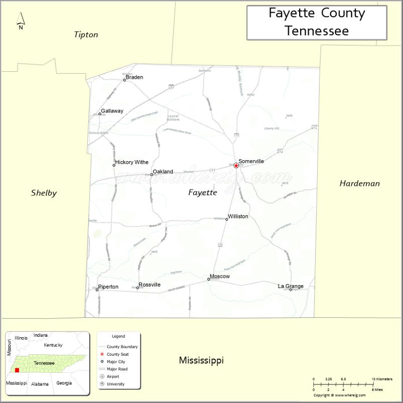
About Fayette County Map, Tennessee: The map showing the county boundary, county seat, major cities, highways and neighbouring counties.
Tennessee More Maps & Info
About Fayette County, Tennessee
Fayette County is a county located in the U.S. state of Tennessee. It's county seat is Somerville. As per 2020 census, the population of Fayette County is 42832 people and population density is square miles. According to the United States Census Bureau, the county has a total area of 705 sq mi (1,826 km2). Fayette County was established on 1824.
Fayette County Facts
| Continent | North America |
| Country | United States |
| State | Tennessee |
| County Seat | Somerville |
| Largest City/Town | Oakland |
| Established | 1824 |
| Total Area | 706 sq mi (1,829 sq km) |
| Land Area | 705 sq mi (1,826 sq km) |
| Water Area | 1 sq mi (3 sq km) |
| Population | 41,990 (Census 2020) |
| Population Density | 60 people per sq mi |
| Time Zone | Central Time Zone (CT) |
| Major Highways | US-64, TN-15, TN-196, TN-76 |
| Neighboring Counties | Tipton County, Haywood County, Hardeman County, Shelby County |
| Famous For | Rural landscapes, historic sites, proximity to Memphis |
| Top Attractions | Ames Plantation, Fayette County Courthouse Square, Herb Parsons Lake (nearby) |
| Official Website | https://www.fayettecountytn.gov |
Cities and Towns in Fayette County, Tennessee
- Somerville (county seat) – 3,094 (Census 2020)
- Oakland – 9,928 (Census 2020)
- Piperton – 2,040 (Census 2020)
- Rossville – 684 (Census 2020)
Roads and Highways in Fayette County
Fayette County is served by several highways that provide access to Memphis and other parts of West Tennessee.
- U.S. Route 64 – runs east–west, connecting to Memphis and Hardeman County
- State Route 15 – links Somerville to neighboring communities
- State Route 196 – connects Oakland to surrounding areas
- State Route 76 – provides regional access across the county
Neighboring Counties of Fayette County
- Tipton County (north)
- Haywood County (east)
- Hardeman County (south)
- Shelby County (west)
Top Attractions in Fayette County
Fayette County offers a mix of history, rural charm, and outdoor recreation.
- Ames Plantation – a historic estate known for research and the National Field Trial Championship
- Fayette County Courthouse Square – a historic downtown area in Somerville
- Herb Parsons Lake (nearby) – popular for fishing, boating, and picnicking
- Oakland City Park – offers walking trails and family-friendly activities
- Rossville Historic District – showcases historic homes and small-town charm
- Somerville Historic District – features classic architecture and local shops
- Gallaway Park – a local spot for recreation and community events
Distance from Fayette County to Nearby Cities
- Fayette County to Memphis – 40 mi (64 km)
- Fayette County to Jackson – 80 mi (129 km)
- Fayette County to Nashville – 200 mi (322 km)
- Fayette County to Little Rock – 150 mi (241 km)
- Fayette County to Birmingham – 230 mi (370 km)
FAQs about Fayette County
Fayette County is located in southwestern Tennessee near the Memphis area.
The county seat is Somerville.
It is known for its rural landscapes, historic sites, and proximity to Memphis.
Main attractions include Ames Plantation and the historic courthouse square in Somerville.
You can reach Fayette County via U.S. Route 64 and several state highways.
- Anderson County Map
- Bedford County Map
- Benton County Map
- Bledsoe County Map
- Blount County Map
- Bradley County Map
- Campbell County Map
- Cannon County Map
- Carroll County Map
- Carter County Map
- Cheatham County Map
- Chester County Map
- Claiborne County Map
- Clay County Map
- Cocke County Map
- Coffee County Map
- Crockett County Map
- Cumberland County Map
- Davidson County Map
- Decatur County Map
- DeKalb County Map
- Dickson County Map
- Dyer County Map
- Fayette County Map
- Fentress County Map
- Franklin County Map
- Gibson County Map
- Giles County Map
- Grainger County Map
- Greene County Map
- Grundy County Map
- Hamblen County Map
- Hamilton County Map
- Hancock County Map
- Hardeman County Map
- Hardin County Map
- Hawkins County Map
- Haywood County Map
- Henderson County Map
- Henry County Map
- Hickman County Map
- Houston County Map
- Humphreys County Map
- Jackson County Map
- Jefferson County Map
- Johnson County Map
- Knox County Map
- Lake County Map
- Lauderdale County Map
- Lawrence County Map
- Lewis County Map
- Lincoln County Map
- Loudon County Map
- McMinn County Map
- McNairy County Map
- Macon County Map
- Madison County Map
- Marion County Map
- Marshall County Map
- Maury County Map
- Meigs County Map
- Monroe County Map
- Montgomery County Map
- Moore County Map
- Morgan County Map
- Obion County Map
- Overton County Map
- Perry County Map
- Pickett County Map
- Polk County Map
- Putnam County Map
- Rhea County Map
- Roane County Map
- Robertson County Map
- Rutherford County Map
- Scott County Map
- Sequatchie County Map
- Sevier County Map
- Shelby County Map
- Smith County Map
- Stewart County Map
- Sullivan County Map
- Sumner County Map
- Tipton County Map
- Trousdale County Map
- Unicoi County Map
- Union County Map
- Van Buren County Map
- Warren County Map
- Washington County Map
- Wayne County Map
- Weakley County Map
- White County Map
- Williamson County Map
- Wilson County Map
- Alabama Counties
- Alaska boroughs
- Arizona Counties
- Arkansas Counties
- California County Map
- Colorado Counties
- Connecticut Counties
- Delaware Counties
- Florida County Map
- Georgia County Map
- Hawaii Counties
- Idaho Counties
- Illinois Counties
- Indiana Counties
- Iowa Counties
- Kansas Counties
- Kentucky Counties
- Louisiana Counties
- Maine Counties
- Maryland Counties
- Massachusetts Counties
- Michigan County Map
- Minnesota Counties
- Mississippi Counties
- Missouri Counties
- Montana Counties
- Nebraska Counties
- Nevada Counties
- New York Counties
- New Hampshire Counties
- New Jersey Counties
- New Mexico Counties
- North Carolina Counties
- North Dakota Counties
- Ohio County Map
- Oklahoma Counties
- Oregon Counties
- Pennsylvania Counties
- Rhode Island Counties
- South Carolina Counties
- South Dakota Counties
- Map of Tennessee
- Texas County Map
- Utah Counties
- Vermont Counties
- Virginia Counties
- Washington Counties
- West Virginia Counties
- Wisconsin Counties
- Wyoming Counties