Map of Knox County - Knox County is a county located in the U.S. state of Tennessee. Knox County Map showing cities, highways, important places and water bodies. Get Where is Knox County located in the map, major cities in Knox county, population, areas, and places of interest.
Map of Knox County, Tennessee
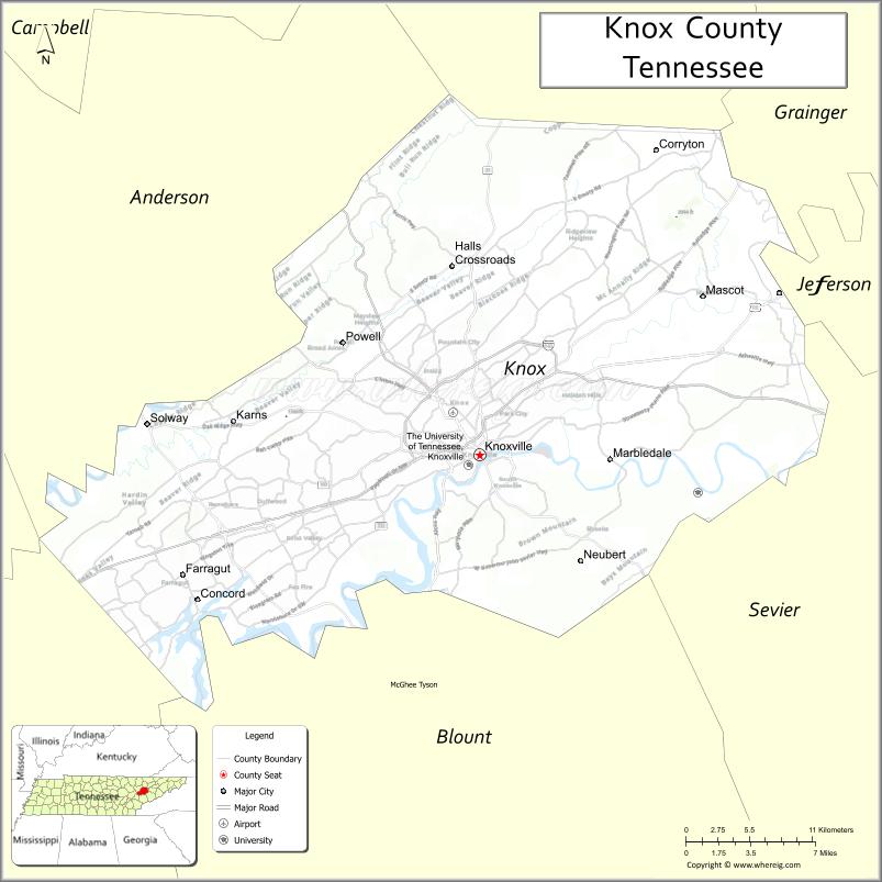
About Knox County Map, Tennessee: The map showing the county boundary, county seat, major cities, highways and neighbouring counties.
Tennessee More Maps & Info
About Knox County, Tennessee
Knox County is a county located in the U.S. state of Tennessee. It's county seat is Knoxville. As per 2020 census, the population of Knox County is 486677 people and population density is square miles. According to the United States Census Bureau, the county has a total area of 509 sq mi (1,318 km2). Knox County was established on 1792.
Knox County Facts
| Continent | North America |
| Country | United States |
| State | Tennessee |
| County Seat | Knoxville |
| Largest City/Town | Knoxville |
| Established | 1792 |
| Total Area | 526 sq mi (1,362 sq km) |
| Land Area | 508 sq mi (1,316 sq km) |
| Water Area | 18 sq mi (47 sq km) |
| Population | 478,971 (Census 2020) |
| Population Density | 943 people per sq mi |
| Time Zone | Eastern Time Zone (ET) |
| Major Highways | I-40, I-75, I-640, US-129, US-441 |
| Neighboring Counties | Anderson County, Union County, Grainger County, Jefferson County, Sevier County, Blount County, Loudon County |
| Famous For | Knoxville, University of Tennessee, Tennessee River |
| Top Attractions | University of Tennessee, Market Square, Knoxville Zoo |
| Official Website | https://www.knoxcounty.org |
Cities and Towns in Knox County, Tennessee
- Knoxville (county seat) – 190,740 (Census 2020)
- Farragut – 23,506 (Census 2020)
- Powell (CDP) – 13,000 (Census 2020)
- Karns (CDP) – 3,500 (Census 2020)
Roads and Highways in Knox County
Knox County is a major transportation hub in East Tennessee with several interstates and highways connecting the region.
- Interstate 40 (I-40) – runs east–west, connecting Knoxville to Nashville and Asheville
- Interstate 75 (I-75) – runs north–south, linking Knoxville to Kentucky and Chattanooga
- Interstate 640 (I-640) – serves as a bypass around Knoxville
- U.S. Route 129 – runs north–south through Knoxville
- U.S. Route 441 – connects Knoxville to the Great Smoky Mountains
Neighboring Counties of Knox County
- Anderson County (northwest)
- Union County (north)
- Grainger County (northeast)
- Jefferson County (east)
- Sevier County (southeast)
- Blount County (south)
- Loudon County (west)
Top Attractions in Knox County
Knox County offers a mix of urban attractions, culture, and outdoor recreation.
- University of Tennessee – a major public university with sports and cultural events
- Market Square – a vibrant downtown area with shops, dining, and events
- Knoxville Zoo – home to a wide variety of animals and exhibits
- Ijams Nature Center – offers hiking trails and outdoor activities
- World’s Fair Park – features the Sunsphere and open green spaces
- Tennessee Theatre – a historic venue for performances and shows
- Knoxville Museum of Art – showcases regional and contemporary art
Distance from Knox County to Nearby Cities
- Knox County to Chattanooga – 110 mi (177 km)
- Knox County to Nashville – 180 mi (290 km)
- Knox County to Asheville – 120 mi (193 km)
- Knox County to Atlanta – 215 mi (346 km)
- Knox County to Lexington – 180 mi (290 km)
FAQs about Knox County
Knox County is located in eastern Tennessee in the United States.
The county seat is Knoxville.
It is known for Knoxville, the University of Tennessee, and the Tennessee River.
Main attractions include Market Square, the Knoxville Zoo, and the University of Tennessee.
You can reach Knox County via Interstates 40, 75, and 640.
- Anderson County Map
- Bedford County Map
- Benton County Map
- Bledsoe County Map
- Blount County Map
- Bradley County Map
- Campbell County Map
- Cannon County Map
- Carroll County Map
- Carter County Map
- Cheatham County Map
- Chester County Map
- Claiborne County Map
- Clay County Map
- Cocke County Map
- Coffee County Map
- Crockett County Map
- Cumberland County Map
- Davidson County Map
- Decatur County Map
- DeKalb County Map
- Dickson County Map
- Dyer County Map
- Fayette County Map
- Fentress County Map
- Franklin County Map
- Gibson County Map
- Giles County Map
- Grainger County Map
- Greene County Map
- Grundy County Map
- Hamblen County Map
- Hamilton County Map
- Hancock County Map
- Hardeman County Map
- Hardin County Map
- Hawkins County Map
- Haywood County Map
- Henderson County Map
- Henry County Map
- Hickman County Map
- Houston County Map
- Humphreys County Map
- Jackson County Map
- Jefferson County Map
- Johnson County Map
- Knox County Map
- Lake County Map
- Lauderdale County Map
- Lawrence County Map
- Lewis County Map
- Lincoln County Map
- Loudon County Map
- McMinn County Map
- McNairy County Map
- Macon County Map
- Madison County Map
- Marion County Map
- Marshall County Map
- Maury County Map
- Meigs County Map
- Monroe County Map
- Montgomery County Map
- Moore County Map
- Morgan County Map
- Obion County Map
- Overton County Map
- Perry County Map
- Pickett County Map
- Polk County Map
- Putnam County Map
- Rhea County Map
- Roane County Map
- Robertson County Map
- Rutherford County Map
- Scott County Map
- Sequatchie County Map
- Sevier County Map
- Shelby County Map
- Smith County Map
- Stewart County Map
- Sullivan County Map
- Sumner County Map
- Tipton County Map
- Trousdale County Map
- Unicoi County Map
- Union County Map
- Van Buren County Map
- Warren County Map
- Washington County Map
- Wayne County Map
- Weakley County Map
- White County Map
- Williamson County Map
- Wilson County Map
- Alabama Counties
- Alaska boroughs
- Arizona Counties
- Arkansas Counties
- California County Map
- Colorado Counties
- Connecticut Counties
- Delaware Counties
- Florida County Map
- Georgia County Map
- Hawaii Counties
- Idaho Counties
- Illinois Counties
- Indiana Counties
- Iowa Counties
- Kansas Counties
- Kentucky Counties
- Louisiana Counties
- Maine Counties
- Maryland Counties
- Massachusetts Counties
- Michigan County Map
- Minnesota Counties
- Mississippi Counties
- Missouri Counties
- Montana Counties
- Nebraska Counties
- Nevada Counties
- New York Counties
- New Hampshire Counties
- New Jersey Counties
- New Mexico Counties
- North Carolina Counties
- North Dakota Counties
- Ohio County Map
- Oklahoma Counties
- Oregon Counties
- Pennsylvania Counties
- Rhode Island Counties
- South Carolina Counties
- South Dakota Counties
- Map of Tennessee
- Texas County Map
- Utah Counties
- Vermont Counties
- Virginia Counties
- Washington Counties
- West Virginia Counties
- Wisconsin Counties
- Wyoming Counties