Map of Smith County - Smith County is a county located in the U.S. state of Tennessee. Smith County Map showing cities, highways, important places and water bodies. Get Where is Smith County located in the map, major cities in Smith county, population, areas, and places of interest.
Map of Smith County, Tennessee
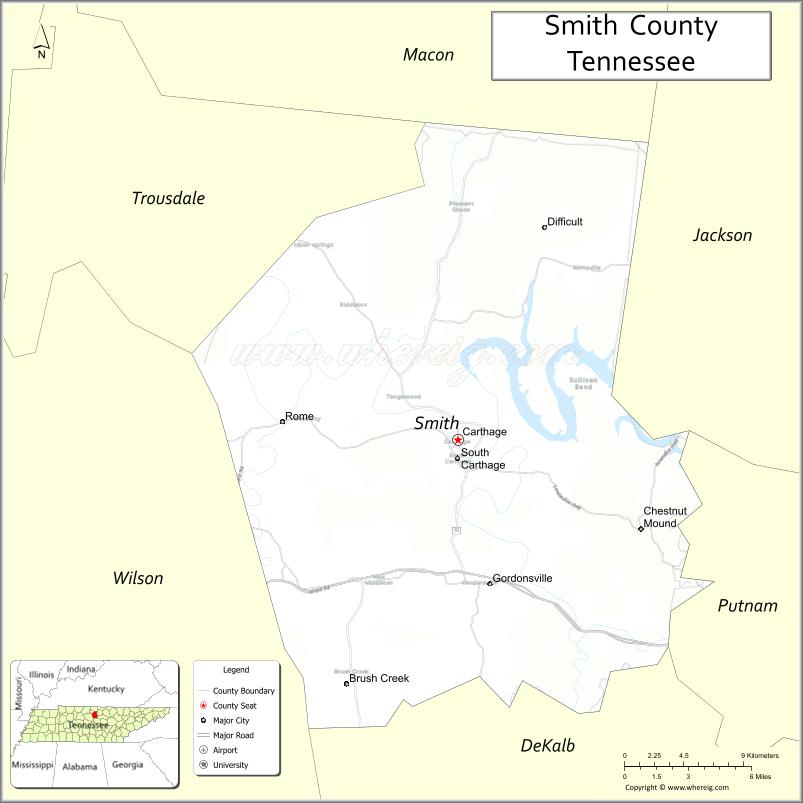
About Smith County Map, Tennessee: The map showing the county boundary, county seat, major cities, highways and neighbouring counties.
Tennessee More Maps & Info
About Smith County, Tennessee
Smith County is a county located in the U.S. state of Tennessee. It's county seat is Carthage. As per 2020 census, the population of Smith County is 20172 people and population density is square miles. According to the United States Census Bureau, the county has a total area of 314 sq mi (813 km2). Smith County was established on 1799.
Smith County Facts
| Continent | North America |
| Country | United States |
| State | Tennessee |
| County Seat | Carthage |
| Largest City/Town | Carthage |
| Established | 1799 |
| Total Area | 325 sq mi |
| Land Area | 314 sq mi |
| Water Area | 11 sq mi |
| Population | 19,904 (Census 2020) |
| Population Density | 63 people per sq mi |
| Time Zone | Central (CST) |
| Major Highways | US-70N, TN-25, TN-53 |
| Neighboring Counties | Macon County, Trousdale County, Wilson County, DeKalb County, Jackson County |
| Famous For | Cumberland River, historic sites, scenic countryside |
| Top Attractions | Cordell Hull Bridge, Defeated Creek Park, Smith County Heritage Museum |
| Official Website | https://smithcountytn.gov |
Cities and Towns in Smith County, Tennessee
- Carthage (county seat) – 2,306 (Census 2020)
- Gordonsville – 1,250 (Census 2020)
- South Carthage – 1,530 (Census 2020)
- Elmwood – 930 (Census 2020)
Roads and Highways in Smith County
Smith County is connected by several highways that link it to nearby counties and cities across Middle Tennessee.
- U.S. Route 70N (US-70N) – Runs east-west connecting Carthage to Lebanon and Cookeville
- Tennessee State Route 25 (TN-25) – Connects the county to Hartsville and Crossville
- Tennessee State Route 53 (TN-53) – Runs north-south linking Carthage to Gainesboro and Liberty
Neighboring Counties of Smith County
- Macon County (north)
- Trousdale County (west)
- Wilson County (southwest)
- DeKalb County (south)
- Jackson County (east)
Top Attractions in Smith County
Smith County offers a quiet mix of river views, parks, and local history in a scenic rural setting.
- Cordell Hull Bridge – Historic bridge over the Cumberland River
- Defeated Creek Park – Popular for camping, fishing, and boating
- Smith County Heritage Museum – Showcases local history and culture
- Cumberland River – Great for fishing and scenic views
- Gordonsville Historic Area – Small-town charm with historic sites
- Warriors Path – Local trails for walking and nature exploration
- South Carthage Riverfront – Relaxing spot along the river
Distance from Smith County to Nearby Cities
- Carthage to Nashville – 55 mi (89 km)
- Carthage to Cookeville – 35 mi (56 km)
- Carthage to Lebanon – 30 mi (48 km)
- Carthage to Gallatin – 45 mi (72 km)
- Carthage to Knoxville – 140 mi (225 km)
FAQs about Smith County
Smith County is known for the Cumberland River, scenic countryside, and historic sites.
Carthage is the county seat and largest town.
The Cumberland River flows through the county.
Yes, it is about 55 miles northeast of Nashville.
Visitors can enjoy fishing, boating, camping, and exploring parks and trails.
- Anderson County Map
- Bedford County Map
- Benton County Map
- Bledsoe County Map
- Blount County Map
- Bradley County Map
- Campbell County Map
- Cannon County Map
- Carroll County Map
- Carter County Map
- Cheatham County Map
- Chester County Map
- Claiborne County Map
- Clay County Map
- Cocke County Map
- Coffee County Map
- Crockett County Map
- Cumberland County Map
- Davidson County Map
- Decatur County Map
- DeKalb County Map
- Dickson County Map
- Dyer County Map
- Fayette County Map
- Fentress County Map
- Franklin County Map
- Gibson County Map
- Giles County Map
- Grainger County Map
- Greene County Map
- Grundy County Map
- Hamblen County Map
- Hamilton County Map
- Hancock County Map
- Hardeman County Map
- Hardin County Map
- Hawkins County Map
- Haywood County Map
- Henderson County Map
- Henry County Map
- Hickman County Map
- Houston County Map
- Humphreys County Map
- Jackson County Map
- Jefferson County Map
- Johnson County Map
- Knox County Map
- Lake County Map
- Lauderdale County Map
- Lawrence County Map
- Lewis County Map
- Lincoln County Map
- Loudon County Map
- McMinn County Map
- McNairy County Map
- Macon County Map
- Madison County Map
- Marion County Map
- Marshall County Map
- Maury County Map
- Meigs County Map
- Monroe County Map
- Montgomery County Map
- Moore County Map
- Morgan County Map
- Obion County Map
- Overton County Map
- Perry County Map
- Pickett County Map
- Polk County Map
- Putnam County Map
- Rhea County Map
- Roane County Map
- Robertson County Map
- Rutherford County Map
- Scott County Map
- Sequatchie County Map
- Sevier County Map
- Shelby County Map
- Smith County Map
- Stewart County Map
- Sullivan County Map
- Sumner County Map
- Tipton County Map
- Trousdale County Map
- Unicoi County Map
- Union County Map
- Van Buren County Map
- Warren County Map
- Washington County Map
- Wayne County Map
- Weakley County Map
- White County Map
- Williamson County Map
- Wilson County Map
- Alabama Counties
- Alaska boroughs
- Arizona Counties
- Arkansas Counties
- California County Map
- Colorado Counties
- Connecticut Counties
- Delaware Counties
- Florida County Map
- Georgia County Map
- Hawaii Counties
- Idaho Counties
- Illinois Counties
- Indiana Counties
- Iowa Counties
- Kansas Counties
- Kentucky Counties
- Louisiana Counties
- Maine Counties
- Maryland Counties
- Massachusetts Counties
- Michigan County Map
- Minnesota Counties
- Mississippi Counties
- Missouri Counties
- Montana Counties
- Nebraska Counties
- Nevada Counties
- New York Counties
- New Hampshire Counties
- New Jersey Counties
- New Mexico Counties
- North Carolina Counties
- North Dakota Counties
- Ohio County Map
- Oklahoma Counties
- Oregon Counties
- Pennsylvania Counties
- Rhode Island Counties
- South Carolina Counties
- South Dakota Counties
- Map of Tennessee
- Texas County Map
- Utah Counties
- Vermont Counties
- Virginia Counties
- Washington Counties
- West Virginia Counties
- Wisconsin Counties
- Wyoming Counties