Map of Rutherford County - Rutherford County is a county located in the U.S. state of Tennessee. Rutherford County Map showing cities, highways, important places and water bodies. Get Where is Rutherford County located in the map, major cities in Rutherford county, population, areas, and places of interest.
Map of Rutherford County, Tennessee
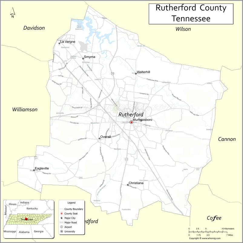
About Rutherford County Map, Tennessee: The map showing the county boundary, county seat, major cities, highways and neighbouring counties.
Tennessee More Maps & Info
About Rutherford County, Tennessee
Rutherford County is a county located in the U.S. state of Tennessee. It's county seat is Murfreesboro. As per 2020 census, the population of Rutherford County is 352182 people and population density is square miles. According to the United States Census Bureau, the county has a total area of 619 sq mi (1,603 km2). Rutherford County was established on 1803.
Rutherford County Facts
| Continent | North America |
| Country | United States |
| State | Tennessee |
| County Seat | Murfreesboro |
| Largest City/Town | Murfreesboro |
| Established | 1803 |
| Total Area | 624 sq mi |
| Land Area | 619 sq mi |
| Water Area | 5 sq mi |
| Population | 341,486 (Census 2020) |
| Population Density | 552 people per sq mi |
| Time Zone | Central (CST) |
| Major Highways | I-24, I-840, US-41, US-70S, TN-96 |
| Neighboring Counties | Wilson County, Cannon County, Coffee County, Bedford County, Marshall County, Williamson County, Davidson County |
| Famous For | Middle Tennessee State University, Civil War history, fast-growing suburbs |
| Top Attractions | Stones River National Battlefield, Cannonsburgh Village, Barfield Crescent Park |
| Official Website | https://rutherfordcountytn.gov |
Cities and Towns in Rutherford County, Tennessee
- Murfreesboro (county seat) – 152,769 (Census 2020)
- Smyrna – 53,070 (Census 2020)
- La Vergne – 39,102 (Census 2020)
- Eagleville – 813 (Census 2020)
Roads and Highways in Rutherford County
Rutherford County has a strong transportation network that connects it directly to Nashville and other major cities in Middle Tennessee.
- Interstate 24 (I-24) – Runs northwest connecting Murfreesboro to Nashville and southeast to Chattanooga
- Interstate 840 (I-840) – Bypass route connecting outer suburbs around Nashville
- U.S. Route 41 (US-41) – Connects local communities across the county
- U.S. Route 70S (US-70S) – Links Murfreesboro to Nashville and eastern Tennessee
- Tennessee State Route 96 (TN-96) – Connects Franklin to Murfreesboro
Neighboring Counties of Rutherford County
- Wilson County (north)
- Cannon County (east)
- Coffee County (southeast)
- Bedford County (south)
- Marshall County (southwest)
- Williamson County (west)
- Davidson County (northwest)
Top Attractions in Rutherford County
Rutherford County offers a mix of history, parks, and family-friendly attractions, especially around Murfreesboro.
- Stones River National Battlefield – Historic Civil War site with walking trails
- Cannonsburgh Village – Recreated historic village with local heritage exhibits
- Barfield Crescent Park – Large park with trails, playgrounds, and picnic areas
- Discovery Center at Murfree Spring – Hands-on science museum for kids
- Oaklands Mansion – Historic home with guided tours
- Stones River Greenway – Scenic trail for walking and biking
- Sharp Springs Park – Popular park in Smyrna with lake and sports facilities
Distance from Rutherford County to Nearby Cities
- Murfreesboro to Nashville – 35 mi (56 km)
- Murfreesboro to Chattanooga – 100 mi (161 km)
- Murfreesboro to Knoxville – 180 mi (290 km)
- Murfreesboro to Franklin – 30 mi (48 km)
- Murfreesboro to Shelbyville – 28 mi (45 km)
FAQs about Rutherford County
Rutherford County is known for its Civil War history, Middle Tennessee State University, and rapid population growth.
Murfreesboro is the county seat and largest city.
It is about 35 miles southeast of Nashville.
Interstate 24 and Interstate 840 are the main highways in the county.
Yes, it is one of the fastest-growing counties in Tennessee due to its proximity to Nashville.
- Anderson County Map
- Bedford County Map
- Benton County Map
- Bledsoe County Map
- Blount County Map
- Bradley County Map
- Campbell County Map
- Cannon County Map
- Carroll County Map
- Carter County Map
- Cheatham County Map
- Chester County Map
- Claiborne County Map
- Clay County Map
- Cocke County Map
- Coffee County Map
- Crockett County Map
- Cumberland County Map
- Davidson County Map
- Decatur County Map
- DeKalb County Map
- Dickson County Map
- Dyer County Map
- Fayette County Map
- Fentress County Map
- Franklin County Map
- Gibson County Map
- Giles County Map
- Grainger County Map
- Greene County Map
- Grundy County Map
- Hamblen County Map
- Hamilton County Map
- Hancock County Map
- Hardeman County Map
- Hardin County Map
- Hawkins County Map
- Haywood County Map
- Henderson County Map
- Henry County Map
- Hickman County Map
- Houston County Map
- Humphreys County Map
- Jackson County Map
- Jefferson County Map
- Johnson County Map
- Knox County Map
- Lake County Map
- Lauderdale County Map
- Lawrence County Map
- Lewis County Map
- Lincoln County Map
- Loudon County Map
- McMinn County Map
- McNairy County Map
- Macon County Map
- Madison County Map
- Marion County Map
- Marshall County Map
- Maury County Map
- Meigs County Map
- Monroe County Map
- Montgomery County Map
- Moore County Map
- Morgan County Map
- Obion County Map
- Overton County Map
- Perry County Map
- Pickett County Map
- Polk County Map
- Putnam County Map
- Rhea County Map
- Roane County Map
- Robertson County Map
- Rutherford County Map
- Scott County Map
- Sequatchie County Map
- Sevier County Map
- Shelby County Map
- Smith County Map
- Stewart County Map
- Sullivan County Map
- Sumner County Map
- Tipton County Map
- Trousdale County Map
- Unicoi County Map
- Union County Map
- Van Buren County Map
- Warren County Map
- Washington County Map
- Wayne County Map
- Weakley County Map
- White County Map
- Williamson County Map
- Wilson County Map
- Alabama Counties
- Alaska boroughs
- Arizona Counties
- Arkansas Counties
- California County Map
- Colorado Counties
- Connecticut Counties
- Delaware Counties
- Florida County Map
- Georgia County Map
- Hawaii Counties
- Idaho Counties
- Illinois Counties
- Indiana Counties
- Iowa Counties
- Kansas Counties
- Kentucky Counties
- Louisiana Counties
- Maine Counties
- Maryland Counties
- Massachusetts Counties
- Michigan County Map
- Minnesota Counties
- Mississippi Counties
- Missouri Counties
- Montana Counties
- Nebraska Counties
- Nevada Counties
- New York Counties
- New Hampshire Counties
- New Jersey Counties
- New Mexico Counties
- North Carolina Counties
- North Dakota Counties
- Ohio County Map
- Oklahoma Counties
- Oregon Counties
- Pennsylvania Counties
- Rhode Island Counties
- South Carolina Counties
- South Dakota Counties
- Map of Tennessee
- Texas County Map
- Utah Counties
- Vermont Counties
- Virginia Counties
- Washington Counties
- West Virginia Counties
- Wisconsin Counties
- Wyoming Counties