Map of Blount County - Blount County is a county located in the U.S. state of Tennessee. Blount County Map showing cities, highways, important places and water bodies. Get Where is Blount County located in the map, major cities in Blount county, population, areas, and places of interest.
Map of Blount County, Tennessee
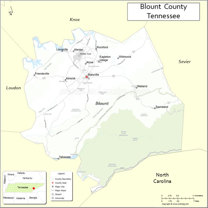
About Blount County Map, Tennessee: The map showing the county boundary, county seat, major cities, highways and neighbouring counties.
Tennessee More Maps & Info
About Blount County, Tennessee
Blount County is a county located in the U.S. state of Tennessee. It's county seat is Maryville. As per 2020 census, the population of Blount County is 137605 people and population density is square miles. According to the United States Census Bureau, the county has a total area of 559 sq mi (1,448 km2). Blount County was established on 1795.
Blount County Facts
| Continent | North America |
| Country | United States |
| State | Tennessee |
| County Seat | Maryville |
| Largest City/Town | Maryville |
| Established | 1795 |
| Total Area | 567 sq mi (1,468 sq km) |
| Land Area | 559 sq mi (1,448 sq km) |
| Water Area | 8 sq mi (21 sq km) |
| Population | 135,280 (Census 2020) |
| Population Density | 242 people per sq mi |
| Time Zone | Eastern Time Zone (ET) |
| Major Highways | US-129, US-411, US-321, TN-33, TN-73 |
| Neighboring Counties | Knox County, Sevier County, Monroe County, Loudon County |
| Famous For | Great Smoky Mountains, scenic drives, outdoor recreation |
| Top Attractions | Great Smoky Mountains National Park, Cades Cove, Foothills Parkway |
| Official Website | https://www.blounttn.org |
Cities and Towns in Blount County, Tennessee
- Maryville (county seat) – 31,907 (Census 2020)
- Alcoa – 10,978 (Census 2020)
- Friendsville – 890 (Census 2020)
- Louisville – 4,256 (Census 2020)
Roads and Highways in Blount County
Blount County has a well-developed road system that connects it to Knoxville and the Great Smoky Mountains region.
- U.S. Route 129 – runs north–south, connecting Knoxville and the Great Smoky Mountains National Park
- U.S. Route 411 – runs north–south, linking Maryville with Sevier and Monroe counties
- U.S. Route 321 – runs east–west, connecting to Lenoir City and the Smoky Mountains
- State Route 33 – connects to Knox County and surrounding areas
- State Route 73 – provides access to scenic mountain routes and the national park
Neighboring Counties of Blount County
- Knox County (north)
- Loudon County (west)
- Monroe County (south)
- Sevier County (east)
Top Attractions in Blount County
Blount County is a gateway to the Smoky Mountains and offers a mix of natural beauty and outdoor adventure.
- Great Smoky Mountains National Park – one of the most visited national parks in the U.S.
- Cades Cove – a scenic valley known for wildlife and historic cabins
- Foothills Parkway – a beautiful drive with mountain views
- Tuckaleechee Caverns – underground caves with guided tours
- Maryville College Woods – peaceful trails and green space
- Bicentennial Greenbelt Park – a popular walking and biking path
- Alcoa Duck Pond Park – family-friendly park with picnic areas
- Rocky Branch Trail – great for hiking and nature exploration
Distance from Blount County to Nearby Cities
- Blount County to Knoxville – 20 mi (32 km)
- Blount County to Chattanooga – 100 mi (161 km)
- Blount County to Asheville – 90 mi (145 km)
- Blount County to Nashville – 180 mi (290 km)
- Blount County to Atlanta – 200 mi (322 km)
FAQs about Blount County
Blount County is located in eastern Tennessee near the Great Smoky Mountains.
The county seat is Maryville.
It is known for its access to the Great Smoky Mountains and scenic outdoor attractions.
Main attractions include Great Smoky Mountains National Park, Cades Cove, and Foothills Parkway.
You can reach Blount County via U.S. Routes 129, 321, and 411 from nearby cities.
- Anderson County Map
- Bedford County Map
- Benton County Map
- Bledsoe County Map
- Blount County Map
- Bradley County Map
- Campbell County Map
- Cannon County Map
- Carroll County Map
- Carter County Map
- Cheatham County Map
- Chester County Map
- Claiborne County Map
- Clay County Map
- Cocke County Map
- Coffee County Map
- Crockett County Map
- Cumberland County Map
- Davidson County Map
- Decatur County Map
- DeKalb County Map
- Dickson County Map
- Dyer County Map
- Fayette County Map
- Fentress County Map
- Franklin County Map
- Gibson County Map
- Giles County Map
- Grainger County Map
- Greene County Map
- Grundy County Map
- Hamblen County Map
- Hamilton County Map
- Hancock County Map
- Hardeman County Map
- Hardin County Map
- Hawkins County Map
- Haywood County Map
- Henderson County Map
- Henry County Map
- Hickman County Map
- Houston County Map
- Humphreys County Map
- Jackson County Map
- Jefferson County Map
- Johnson County Map
- Knox County Map
- Lake County Map
- Lauderdale County Map
- Lawrence County Map
- Lewis County Map
- Lincoln County Map
- Loudon County Map
- McMinn County Map
- McNairy County Map
- Macon County Map
- Madison County Map
- Marion County Map
- Marshall County Map
- Maury County Map
- Meigs County Map
- Monroe County Map
- Montgomery County Map
- Moore County Map
- Morgan County Map
- Obion County Map
- Overton County Map
- Perry County Map
- Pickett County Map
- Polk County Map
- Putnam County Map
- Rhea County Map
- Roane County Map
- Robertson County Map
- Rutherford County Map
- Scott County Map
- Sequatchie County Map
- Sevier County Map
- Shelby County Map
- Smith County Map
- Stewart County Map
- Sullivan County Map
- Sumner County Map
- Tipton County Map
- Trousdale County Map
- Unicoi County Map
- Union County Map
- Van Buren County Map
- Warren County Map
- Washington County Map
- Wayne County Map
- Weakley County Map
- White County Map
- Williamson County Map
- Wilson County Map
- Alabama Counties
- Alaska boroughs
- Arizona Counties
- Arkansas Counties
- California County Map
- Colorado Counties
- Connecticut Counties
- Delaware Counties
- Florida County Map
- Georgia County Map
- Hawaii Counties
- Idaho Counties
- Illinois Counties
- Indiana Counties
- Iowa Counties
- Kansas Counties
- Kentucky Counties
- Louisiana Counties
- Maine Counties
- Maryland Counties
- Massachusetts Counties
- Michigan County Map
- Minnesota Counties
- Mississippi Counties
- Missouri Counties
- Montana Counties
- Nebraska Counties
- Nevada Counties
- New York Counties
- New Hampshire Counties
- New Jersey Counties
- New Mexico Counties
- North Carolina Counties
- North Dakota Counties
- Ohio County Map
- Oklahoma Counties
- Oregon Counties
- Pennsylvania Counties
- Rhode Island Counties
- South Carolina Counties
- South Dakota Counties
- Map of Tennessee
- Texas County Map
- Utah Counties
- Vermont Counties
- Virginia Counties
- Washington Counties
- West Virginia Counties
- Wisconsin Counties
- Wyoming Counties