Map of Robertson County - Robertson County is a county located in the U.S. state of Tennessee. Robertson County Map showing cities, highways, important places and water bodies. Get Where is Robertson County located in the map, major cities in Robertson county, population, areas, and places of interest.
Map of Robertson County, Tennessee
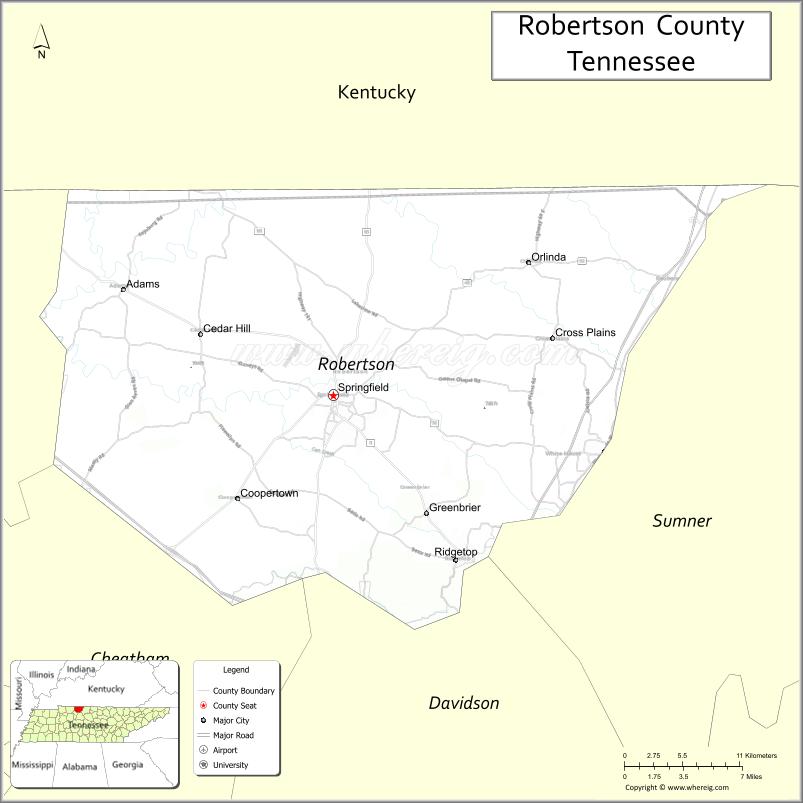
About Robertson County Map, Tennessee: The map showing the county boundary, county seat, major cities, highways and neighbouring counties.
Tennessee More Maps & Info
About Robertson County, Tennessee
Robertson County is a county located in the U.S. state of Tennessee. It's county seat is Springfield. As per 2020 census, the population of Robertson County is 74098 people and population density is square miles. According to the United States Census Bureau, the county has a total area of 477 sq mi (1,235 km2). Robertson County was established on 1796.
Robertson County Facts
| Continent | North America |
| Country | United States |
| State | Tennessee |
| County Seat | Springfield |
| Largest City/Town | Springfield |
| Established | 1796 |
| Total Area | 477 sq mi |
| Land Area | 476 sq mi |
| Water Area | 1 sq mi |
| Population | 72,803 (Census 2020) |
| Population Density | 153 people per sq mi |
| Time Zone | Central (CST) |
| Major Highways | I-24, US-41, US-431, TN-76 |
| Neighboring Counties | Sumner County, Davidson County, Cheatham County, Montgomery County (TN), Logan County (KY), Simpson County (KY) |
| Famous For | Tobacco farming, historic sites, rural landscapes |
| Top Attractions | Port Royal State Historic Park, J. Travis Price Park, Robertson County Fairgrounds |
| Official Website | https://www.robertsoncountytn.org |
Cities and Towns in Robertson County, Tennessee
- Springfield (county seat) – 18,782 (Census 2020)
- White House – 12,982 (Census 2020)
- Greenbrier – 6,898 (Census 2020)
- Cross Plains – 1,812 (Census 2020)
Roads and Highways in Robertson County
Robertson County is served by key highways that connect it to Nashville and nearby regions in both Tennessee and Kentucky.
- Interstate 24 (I-24) – Runs southeast connecting the county to Nashville and Clarksville
- U.S. Route 41 (US-41) – North-south route linking Springfield to Kentucky and Nashville
- U.S. Route 431 (US-431) – Connects Springfield to Bowling Green, KY and central Tennessee
- Tennessee State Route 76 (TN-76) – East-west route linking White House to Springfield and Clarksville
Neighboring Counties of Robertson County
- Sumner County (east)
- Davidson County (southeast)
- Cheatham County (south)
- Montgomery County, TN (west)
- Logan County, KY (northwest)
- Simpson County, KY (north)
Top Attractions in Robertson County
Robertson County offers a mix of history, parks, and local culture, with easy access to the Nashville area.
- Port Royal State Historic Park – Historic town site with walking trails and river views
- J. Travis Price Park – Popular for picnics, trails, and community events
- Robertson County Fairgrounds – Hosts local fairs and seasonal events
- Springfield Historic District – Features classic architecture and small-town charm
- Kilgore Park – A quiet park space for outdoor relaxation
- White House Greenway – Scenic walking and biking trail
- Garner Street Park – Family-friendly park in Springfield
Distance from Robertson County to Nearby Cities
- Springfield to Nashville – 30 mi (48 km)
- Springfield to Clarksville – 26 mi (42 km)
- Springfield to Bowling Green – 45 mi (72 km)
- Springfield to Franklin – 45 mi (72 km)
- Springfield to Hopkinsville – 50 mi (80 km)
FAQs about Robertson County
Robertson County is known for tobacco farming, historic sites, and its rural landscapes.
Springfield is the county seat and largest city in Robertson County.
It is about 30 miles north of Nashville.
The county borders Kentucky to the north.
Interstate 24 and U.S. Routes 41 and 431 are the main highways.
- Anderson County Map
- Bedford County Map
- Benton County Map
- Bledsoe County Map
- Blount County Map
- Bradley County Map
- Campbell County Map
- Cannon County Map
- Carroll County Map
- Carter County Map
- Cheatham County Map
- Chester County Map
- Claiborne County Map
- Clay County Map
- Cocke County Map
- Coffee County Map
- Crockett County Map
- Cumberland County Map
- Davidson County Map
- Decatur County Map
- DeKalb County Map
- Dickson County Map
- Dyer County Map
- Fayette County Map
- Fentress County Map
- Franklin County Map
- Gibson County Map
- Giles County Map
- Grainger County Map
- Greene County Map
- Grundy County Map
- Hamblen County Map
- Hamilton County Map
- Hancock County Map
- Hardeman County Map
- Hardin County Map
- Hawkins County Map
- Haywood County Map
- Henderson County Map
- Henry County Map
- Hickman County Map
- Houston County Map
- Humphreys County Map
- Jackson County Map
- Jefferson County Map
- Johnson County Map
- Knox County Map
- Lake County Map
- Lauderdale County Map
- Lawrence County Map
- Lewis County Map
- Lincoln County Map
- Loudon County Map
- McMinn County Map
- McNairy County Map
- Macon County Map
- Madison County Map
- Marion County Map
- Marshall County Map
- Maury County Map
- Meigs County Map
- Monroe County Map
- Montgomery County Map
- Moore County Map
- Morgan County Map
- Obion County Map
- Overton County Map
- Perry County Map
- Pickett County Map
- Polk County Map
- Putnam County Map
- Rhea County Map
- Roane County Map
- Robertson County Map
- Rutherford County Map
- Scott County Map
- Sequatchie County Map
- Sevier County Map
- Shelby County Map
- Smith County Map
- Stewart County Map
- Sullivan County Map
- Sumner County Map
- Tipton County Map
- Trousdale County Map
- Unicoi County Map
- Union County Map
- Van Buren County Map
- Warren County Map
- Washington County Map
- Wayne County Map
- Weakley County Map
- White County Map
- Williamson County Map
- Wilson County Map
- Alabama Counties
- Alaska boroughs
- Arizona Counties
- Arkansas Counties
- California County Map
- Colorado Counties
- Connecticut Counties
- Delaware Counties
- Florida County Map
- Georgia County Map
- Hawaii Counties
- Idaho Counties
- Illinois Counties
- Indiana Counties
- Iowa Counties
- Kansas Counties
- Kentucky Counties
- Louisiana Counties
- Maine Counties
- Maryland Counties
- Massachusetts Counties
- Michigan County Map
- Minnesota Counties
- Mississippi Counties
- Missouri Counties
- Montana Counties
- Nebraska Counties
- Nevada Counties
- New York Counties
- New Hampshire Counties
- New Jersey Counties
- New Mexico Counties
- North Carolina Counties
- North Dakota Counties
- Ohio County Map
- Oklahoma Counties
- Oregon Counties
- Pennsylvania Counties
- Rhode Island Counties
- South Carolina Counties
- South Dakota Counties
- Map of Tennessee
- Texas County Map
- Utah Counties
- Vermont Counties
- Virginia Counties
- Washington Counties
- West Virginia Counties
- Wisconsin Counties
- Wyoming Counties