Map of Hamilton County - Hamilton County is a county located in the U.S. state of Tennessee. Hamilton County Map showing cities, highways, important places and water bodies. Get Where is Hamilton County located in the map, major cities in Hamilton county, population, areas, and places of interest.
Map of Hamilton County, Tennessee
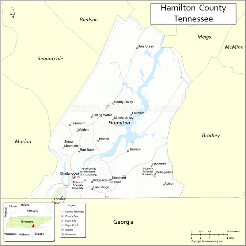
About Hamilton County Map, Tennessee: The map showing the county boundary, county seat, major cities, highways and neighbouring counties.
Tennessee More Maps & Info
About Hamilton County, Tennessee
Hamilton County is a county located in the U.S. state of Tennessee. It's county seat is Chattanooga. As per 2020 census, the population of Hamilton County is 369135 people and population density is square miles. According to the United States Census Bureau, the county has a total area of 543 sq mi (1,406 km2). Hamilton County was established on 1819.
Hamilton County Facts
| Continent | North America |
| Country | United States |
| State | Tennessee |
| County Seat | Chattanooga |
| Largest City/Town | Chattanooga |
| Established | 1819 |
| Total Area | 576 sq mi (1,492 sq km) |
| Land Area | 542 sq mi (1,404 sq km) |
| Water Area | 34 sq mi (88 sq km) |
| Population | 366,207 (Census 2020) |
| Population Density | 676 people per sq mi |
| Time Zone | Eastern Time Zone (ET) |
| Major Highways | I-24, I-75, I-59, US-27, US-11 |
| Neighboring Counties | Bradley County, Rhea County, Bledsoe County, Marion County, Sequatchie County, Walker County (GA), Catoosa County (GA) |
| Famous For | Chattanooga, Tennessee River, Lookout Mountain |
| Top Attractions | Lookout Mountain, Tennessee Aquarium, Ruby Falls |
| Official Website | https://www.hamiltontn.gov |
Cities and Towns in Hamilton County, Tennessee
- Chattanooga (county seat) – 181,099 (Census 2020)
- East Ridge – 21,591 (Census 2020)
- Soddy-Daisy – 13,619 (Census 2020)
- Red Bank – 11,652 (Census 2020)
Roads and Highways in Hamilton County
Hamilton County is a major transportation hub in southeastern Tennessee with several interstates and highways connecting the region.
- Interstate 24 (I-24) – runs northwest–southeast, connecting Nashville and Chattanooga
- Interstate 75 (I-75) – runs north–south, linking Chattanooga to Knoxville and Atlanta
- Interstate 59 (I-59) – connects Chattanooga to Birmingham
- U.S. Route 27 – runs through Chattanooga, connecting to northern and southern regions
- U.S. Route 11 – provides additional regional connectivity
Neighboring Counties of Hamilton County
- Rhea County (north)
- Bledsoe County (northeast)
- Bradley County (east)
- Marion County (west)
- Sequatchie County (northwest)
- Walker County, Georgia (south)
- Catoosa County, Georgia (southeast)
Top Attractions in Hamilton County
Hamilton County is home to Chattanooga and offers a wide range of attractions, from natural landmarks to family-friendly sites.
- Lookout Mountain – offers scenic views, hiking, and attractions like Rock City
- Tennessee Aquarium – one of the top aquariums in the United States
- Ruby Falls – an underground waterfall located inside Lookout Mountain
- Chattanooga Riverwalk – a scenic path along the Tennessee River
- Creative Discovery Museum – a hands-on museum for children
- Incline Railway – a historic railway with steep climbs and views
- Chattanooga Zoo – features a variety of animals and exhibits
Distance from Hamilton County to Nearby Cities
- Hamilton County to Nashville – 135 mi (217 km)
- Hamilton County to Knoxville – 110 mi (177 km)
- Hamilton County to Atlanta – 120 mi (193 km)
- Hamilton County to Birmingham – 150 mi (241 km)
- Hamilton County to Huntsville – 100 mi (161 km)
FAQs about Hamilton County
Hamilton County is located in southeastern Tennessee along the Georgia border.
The county seat is Chattanooga.
It is known for Chattanooga, the Tennessee River, and scenic Lookout Mountain.
Main attractions include the Tennessee Aquarium, Ruby Falls, and Lookout Mountain.
You can reach Hamilton County via Interstates 24, 75, and 59.
- Anderson County Map
- Bedford County Map
- Benton County Map
- Bledsoe County Map
- Blount County Map
- Bradley County Map
- Campbell County Map
- Cannon County Map
- Carroll County Map
- Carter County Map
- Cheatham County Map
- Chester County Map
- Claiborne County Map
- Clay County Map
- Cocke County Map
- Coffee County Map
- Crockett County Map
- Cumberland County Map
- Davidson County Map
- Decatur County Map
- DeKalb County Map
- Dickson County Map
- Dyer County Map
- Fayette County Map
- Fentress County Map
- Franklin County Map
- Gibson County Map
- Giles County Map
- Grainger County Map
- Greene County Map
- Grundy County Map
- Hamblen County Map
- Hamilton County Map
- Hancock County Map
- Hardeman County Map
- Hardin County Map
- Hawkins County Map
- Haywood County Map
- Henderson County Map
- Henry County Map
- Hickman County Map
- Houston County Map
- Humphreys County Map
- Jackson County Map
- Jefferson County Map
- Johnson County Map
- Knox County Map
- Lake County Map
- Lauderdale County Map
- Lawrence County Map
- Lewis County Map
- Lincoln County Map
- Loudon County Map
- McMinn County Map
- McNairy County Map
- Macon County Map
- Madison County Map
- Marion County Map
- Marshall County Map
- Maury County Map
- Meigs County Map
- Monroe County Map
- Montgomery County Map
- Moore County Map
- Morgan County Map
- Obion County Map
- Overton County Map
- Perry County Map
- Pickett County Map
- Polk County Map
- Putnam County Map
- Rhea County Map
- Roane County Map
- Robertson County Map
- Rutherford County Map
- Scott County Map
- Sequatchie County Map
- Sevier County Map
- Shelby County Map
- Smith County Map
- Stewart County Map
- Sullivan County Map
- Sumner County Map
- Tipton County Map
- Trousdale County Map
- Unicoi County Map
- Union County Map
- Van Buren County Map
- Warren County Map
- Washington County Map
- Wayne County Map
- Weakley County Map
- White County Map
- Williamson County Map
- Wilson County Map
- Alabama Counties
- Alaska boroughs
- Arizona Counties
- Arkansas Counties
- California County Map
- Colorado Counties
- Connecticut Counties
- Delaware Counties
- Florida County Map
- Georgia County Map
- Hawaii Counties
- Idaho Counties
- Illinois Counties
- Indiana Counties
- Iowa Counties
- Kansas Counties
- Kentucky Counties
- Louisiana Counties
- Maine Counties
- Maryland Counties
- Massachusetts Counties
- Michigan County Map
- Minnesota Counties
- Mississippi Counties
- Missouri Counties
- Montana Counties
- Nebraska Counties
- Nevada Counties
- New York Counties
- New Hampshire Counties
- New Jersey Counties
- New Mexico Counties
- North Carolina Counties
- North Dakota Counties
- Ohio County Map
- Oklahoma Counties
- Oregon Counties
- Pennsylvania Counties
- Rhode Island Counties
- South Carolina Counties
- South Dakota Counties
- Map of Tennessee
- Texas County Map
- Utah Counties
- Vermont Counties
- Virginia Counties
- Washington Counties
- West Virginia Counties
- Wisconsin Counties
- Wyoming Counties