Map of Washington County - Washington County is a county located in the U.S. state of Tennessee. Washington County Map showing cities, highways, important places and water bodies. Get Where is Washington County located in the map, major cities in Washington county, population, areas, and places of interest.
Map of Washington County, Tennessee
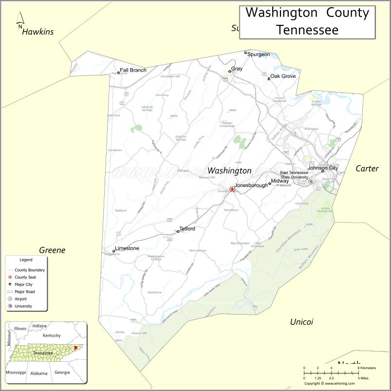
About Washington County Map, Tennessee: The map showing the county boundary, county seat, major cities, highways and neighbouring counties.
Tennessee More Maps & Info
About Washington County, Tennessee
Washington County is a county located in the U.S. state of Tennessee. It's county seat is Jonesborough. As per 2020 census, the population of Washington County is 134236 people and population density is square miles. According to the United States Census Bureau, the county has a total area of 326 sq mi (844 km2). Washington County was established on 1777.
Washington County Facts
| Continent | North America |
| Country | United States |
| State | Tennessee |
| County Seat | Jonesborough |
| Largest City/Town | Johnson City |
| Established | 1777 |
| Total Area | 329 sq mi |
| Land Area | 326 sq mi |
| Water Area | 3 sq mi |
| Population | 133,001 (Census 2020) |
| Population Density | 408 people per sq mi |
| Time Zone | Eastern (EST) |
| Major Highways | I-26, US-11E, US-19W, US-321 |
| Neighboring Counties | Sullivan County, Carter County, Unicoi County, Greene County, Hawkins County |
| Famous For | Jonesborough (Tennessee’s oldest town), storytelling, East Tennessee State University |
| Top Attractions | Historic Jonesborough, Winged Deer Park, Hands On! Discovery Center |
| Official Website | https://www.washingtoncountytn.org |
Cities and Towns in Washington County, Tennessee
- Jonesborough (county seat) – 5,860 (Census 2020)
- Johnson City – 71,046 (Census 2020)
- Gray – 1,200 (approx. community)
- Telford – 900 (approx. community)
Roads and Highways in Washington County
Washington County is well connected through major highways that link it to the Tri-Cities region and nearby states.
- Interstate 26 (I-26) – Runs east-west connecting Johnson City to Asheville, NC and Kingsport
- U.S. Route 11E (US-11E) – Connects Jonesborough to Greeneville and Bristol
- U.S. Route 19W (US-19W) – Links the county to North Carolina and Sullivan County
- U.S. Route 321 (US-321) – Connects Johnson City to Elizabethton and Lenoir City
Neighboring Counties of Washington County
- Sullivan County (north)
- Carter County (east)
- Unicoi County (south)
- Greene County (southwest)
- Hawkins County (west)
Top Attractions in Washington County
Washington County blends history, education, and outdoor recreation in the heart of the Tri-Cities region.
- Historic Jonesborough – Tennessee’s oldest town with museums and storytelling events
- Winged Deer Park – Large park with trails, lake access, and sports facilities
- Hands On! Discovery Center – Interactive museum for children and families
- Buffalo Mountain Park – Scenic hiking area with mountain views
- Founders Park – Popular green space in Johnson City
- East Tennessee State University – Major educational institution with cultural events
- Boone Lake – Ideal for boating, fishing, and recreation
Distance from Washington County to Nearby Cities
- Johnson City to Knoxville – 110 mi (177 km)
- Johnson City to Asheville – 60 mi (97 km)
- Johnson City to Bristol – 25 mi (40 km)
- Johnson City to Nashville – 285 mi (459 km)
- Johnson City to Roanoke – 140 mi (225 km)
FAQs about Washington County
Washington County is known for Jonesborough, Tennessee’s oldest town, and its storytelling heritage.
Jonesborough is the county seat of Washington County.
Johnson City is the largest city in the county.
Yes, it is part of the Tri-Cities region along with Sullivan and Carter counties.
Visitors can enjoy hiking, boating, fishing, and exploring parks and lakes.
- Anderson County Map
- Bedford County Map
- Benton County Map
- Bledsoe County Map
- Blount County Map
- Bradley County Map
- Campbell County Map
- Cannon County Map
- Carroll County Map
- Carter County Map
- Cheatham County Map
- Chester County Map
- Claiborne County Map
- Clay County Map
- Cocke County Map
- Coffee County Map
- Crockett County Map
- Cumberland County Map
- Davidson County Map
- Decatur County Map
- DeKalb County Map
- Dickson County Map
- Dyer County Map
- Fayette County Map
- Fentress County Map
- Franklin County Map
- Gibson County Map
- Giles County Map
- Grainger County Map
- Greene County Map
- Grundy County Map
- Hamblen County Map
- Hamilton County Map
- Hancock County Map
- Hardeman County Map
- Hardin County Map
- Hawkins County Map
- Haywood County Map
- Henderson County Map
- Henry County Map
- Hickman County Map
- Houston County Map
- Humphreys County Map
- Jackson County Map
- Jefferson County Map
- Johnson County Map
- Knox County Map
- Lake County Map
- Lauderdale County Map
- Lawrence County Map
- Lewis County Map
- Lincoln County Map
- Loudon County Map
- McMinn County Map
- McNairy County Map
- Macon County Map
- Madison County Map
- Marion County Map
- Marshall County Map
- Maury County Map
- Meigs County Map
- Monroe County Map
- Montgomery County Map
- Moore County Map
- Morgan County Map
- Obion County Map
- Overton County Map
- Perry County Map
- Pickett County Map
- Polk County Map
- Putnam County Map
- Rhea County Map
- Roane County Map
- Robertson County Map
- Rutherford County Map
- Scott County Map
- Sequatchie County Map
- Sevier County Map
- Shelby County Map
- Smith County Map
- Stewart County Map
- Sullivan County Map
- Sumner County Map
- Tipton County Map
- Trousdale County Map
- Unicoi County Map
- Union County Map
- Van Buren County Map
- Warren County Map
- Washington County Map
- Wayne County Map
- Weakley County Map
- White County Map
- Williamson County Map
- Wilson County Map
- Alabama Counties
- Alaska boroughs
- Arizona Counties
- Arkansas Counties
- California County Map
- Colorado Counties
- Connecticut Counties
- Delaware Counties
- Florida County Map
- Georgia County Map
- Hawaii Counties
- Idaho Counties
- Illinois Counties
- Indiana Counties
- Iowa Counties
- Kansas Counties
- Kentucky Counties
- Louisiana Counties
- Maine Counties
- Maryland Counties
- Massachusetts Counties
- Michigan County Map
- Minnesota Counties
- Mississippi Counties
- Missouri Counties
- Montana Counties
- Nebraska Counties
- Nevada Counties
- New York Counties
- New Hampshire Counties
- New Jersey Counties
- New Mexico Counties
- North Carolina Counties
- North Dakota Counties
- Ohio County Map
- Oklahoma Counties
- Oregon Counties
- Pennsylvania Counties
- Rhode Island Counties
- South Carolina Counties
- South Dakota Counties
- Map of Tennessee
- Texas County Map
- Utah Counties
- Vermont Counties
- Virginia Counties
- Washington Counties
- West Virginia Counties
- Wisconsin Counties
- Wyoming Counties