Map of Sevier County - Sevier County is a county located in the U.S. state of Tennessee. Sevier County Map showing cities, highways, important places and water bodies. Get Where is Sevier County located in the map, major cities in Sevier county, population, areas, and places of interest.
Map of Sevier County, Tennessee
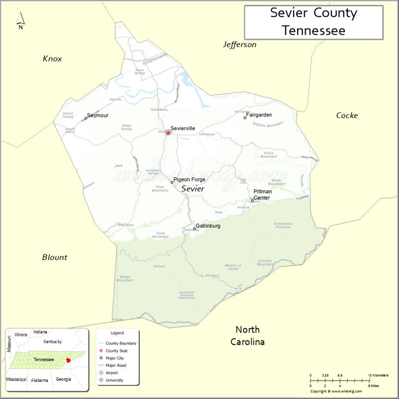
About Sevier County Map, Tennessee: The map showing the county boundary, county seat, major cities, highways and neighbouring counties.
Tennessee More Maps & Info
About Sevier County, Tennessee
Sevier County is a county located in the U.S. state of Tennessee. It's county seat is Sevierville. As per 2020 census, the population of Sevier County is 99517 people and population density is square miles. According to the United States Census Bureau, the county has a total area of 592 sq mi (1,533 km2). Sevier County was established on 1794.
Sevier County Facts
| Continent | North America |
| Country | United States |
| State | Tennessee |
| County Seat | Sevierville |
| Largest City/Town | Sevierville |
| Established | 1794 |
| Total Area | 598 sq mi |
| Land Area | 592 sq mi |
| Water Area | 6 sq mi |
| Population | 98,380 (Census 2020) |
| Population Density | 166 people per sq mi |
| Time Zone | Eastern (EST) |
| Major Highways | US-441, US-321, TN-66, TN-339 |
| Neighboring Counties | Jefferson County, Cocke County, Blount County, Knox County |
| Famous For | Great Smoky Mountains, tourism, Dollywood |
| Top Attractions | Great Smoky Mountains National Park, Dollywood, Gatlinburg |
| Official Website | https://www.seviercountytn.gov |
Cities and Towns in Sevier County, Tennessee
- Sevierville (county seat) – 17,889 (Census 2020)
- Gatlinburg – 3,577 (Census 2020)
- Pigeon Forge – 6,343 (Census 2020)
- Pittman Center – 573 (Census 2020)
Roads and Highways in Sevier County
Sevier County has a well-used highway network that supports heavy tourism traffic and connects the region to nearby cities and national parks.
- U.S. Route 441 (US-441) – Main route connecting Sevierville, Pigeon Forge, and Gatlinburg to the Great Smoky Mountains National Park
- U.S. Route 321 (US-321) – Connects the county to Knoxville and eastern mountain areas
- Tennessee State Route 66 (TN-66) – Major corridor linking I-40 to Sevierville
- Tennessee State Route 339 (TN-339) – Scenic route connecting Sevierville to surrounding rural areas
Neighboring Counties of Sevier County
- Jefferson County (north)
- Cocke County (east)
- Blount County (west)
- Knox County (northwest)
Top Attractions in Sevier County
Sevier County is one of the most visited areas in Tennessee, known for its mountains, entertainment, and family attractions.
- Great Smoky Mountains National Park – Popular for hiking, wildlife, and scenic drives
- Dollywood – Famous theme park with rides, shows, and festivals
- Gatlinburg Strip – Busy area with shops, attractions, and restaurants
- Pigeon Forge Parkway – Entertainment hub with theaters and attractions
- Ober Mountain – Offers skiing, tram rides, and mountain views
- Ripley's Aquarium of the Smokies – Family-friendly aquarium in Gatlinburg
- Anakeesta – Outdoor adventure park with treetop walks and views
Distance from Sevier County to Nearby Cities
- Sevierville to Knoxville – 25 mi (40 km)
- Sevierville to Asheville – 85 mi (137 km)
- Sevierville to Chattanooga – 140 mi (225 km)
- Sevierville to Nashville – 215 mi (346 km)
- Sevierville to Johnson City – 95 mi (153 km)
FAQs about Sevier County
Sevier County is known for the Great Smoky Mountains, tourism, and attractions like Dollywood.
Sevierville is the county seat and largest city.
The Great Smoky Mountains National Park is partly located in Sevier County.
Yes, it is one of the top tourist destinations in Tennessee.
It is about 25 miles southeast of Knoxville.
- Anderson County Map
- Bedford County Map
- Benton County Map
- Bledsoe County Map
- Blount County Map
- Bradley County Map
- Campbell County Map
- Cannon County Map
- Carroll County Map
- Carter County Map
- Cheatham County Map
- Chester County Map
- Claiborne County Map
- Clay County Map
- Cocke County Map
- Coffee County Map
- Crockett County Map
- Cumberland County Map
- Davidson County Map
- Decatur County Map
- DeKalb County Map
- Dickson County Map
- Dyer County Map
- Fayette County Map
- Fentress County Map
- Franklin County Map
- Gibson County Map
- Giles County Map
- Grainger County Map
- Greene County Map
- Grundy County Map
- Hamblen County Map
- Hamilton County Map
- Hancock County Map
- Hardeman County Map
- Hardin County Map
- Hawkins County Map
- Haywood County Map
- Henderson County Map
- Henry County Map
- Hickman County Map
- Houston County Map
- Humphreys County Map
- Jackson County Map
- Jefferson County Map
- Johnson County Map
- Knox County Map
- Lake County Map
- Lauderdale County Map
- Lawrence County Map
- Lewis County Map
- Lincoln County Map
- Loudon County Map
- McMinn County Map
- McNairy County Map
- Macon County Map
- Madison County Map
- Marion County Map
- Marshall County Map
- Maury County Map
- Meigs County Map
- Monroe County Map
- Montgomery County Map
- Moore County Map
- Morgan County Map
- Obion County Map
- Overton County Map
- Perry County Map
- Pickett County Map
- Polk County Map
- Putnam County Map
- Rhea County Map
- Roane County Map
- Robertson County Map
- Rutherford County Map
- Scott County Map
- Sequatchie County Map
- Sevier County Map
- Shelby County Map
- Smith County Map
- Stewart County Map
- Sullivan County Map
- Sumner County Map
- Tipton County Map
- Trousdale County Map
- Unicoi County Map
- Union County Map
- Van Buren County Map
- Warren County Map
- Washington County Map
- Wayne County Map
- Weakley County Map
- White County Map
- Williamson County Map
- Wilson County Map
- Alabama Counties
- Alaska boroughs
- Arizona Counties
- Arkansas Counties
- California County Map
- Colorado Counties
- Connecticut Counties
- Delaware Counties
- Florida County Map
- Georgia County Map
- Hawaii Counties
- Idaho Counties
- Illinois Counties
- Indiana Counties
- Iowa Counties
- Kansas Counties
- Kentucky Counties
- Louisiana Counties
- Maine Counties
- Maryland Counties
- Massachusetts Counties
- Michigan County Map
- Minnesota Counties
- Mississippi Counties
- Missouri Counties
- Montana Counties
- Nebraska Counties
- Nevada Counties
- New York Counties
- New Hampshire Counties
- New Jersey Counties
- New Mexico Counties
- North Carolina Counties
- North Dakota Counties
- Ohio County Map
- Oklahoma Counties
- Oregon Counties
- Pennsylvania Counties
- Rhode Island Counties
- South Carolina Counties
- South Dakota Counties
- Map of Tennessee
- Texas County Map
- Utah Counties
- Vermont Counties
- Virginia Counties
- Washington Counties
- West Virginia Counties
- Wisconsin Counties
- Wyoming Counties