Map of Scott County - Scott County is a county located in the U.S. state of Tennessee. Scott County Map showing cities, highways, important places and water bodies. Get Where is Scott County located in the map, major cities in Scott county, population, areas, and places of interest.
Map of Scott County, Tennessee
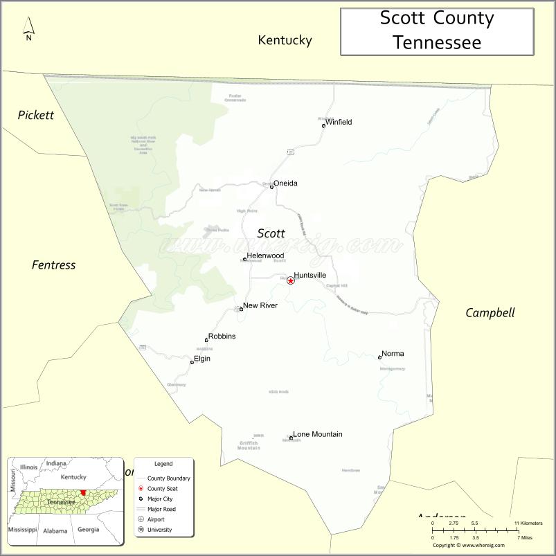
About Scott County Map, Tennessee: The map showing the county boundary, county seat, major cities, highways and neighbouring counties.
Tennessee More Maps & Info
About Scott County, Tennessee
Scott County is a county located in the U.S. state of Tennessee. It's county seat is Huntsville. As per 2020 census, the population of Scott County is 21917 people and population density is square miles. According to the United States Census Bureau, the county has a total area of 532 sq mi (1,378 km2). Scott County was established on 1849.
Scott County Facts
| Continent | North America |
| Country | United States |
| State | Tennessee |
| County Seat | Huntsville |
| Largest City/Town | Oneida |
| Established | 1849 |
| Total Area | 549 sq mi |
| Land Area | 533 sq mi |
| Water Area | 16 sq mi |
| Population | 21,576 (Census 2020) |
| Population Density | 40 people per sq mi |
| Time Zone | Eastern (EST) |
| Major Highways | US-27, TN-63, TN-297 |
| Neighboring Counties | McCreary County (KY), Campbell County, Anderson County, Morgan County, Fentress County |
| Famous For | Big South Fork National River, coal mining history, scenic mountains |
| Top Attractions | Big South Fork National River and Recreation Area, Rugby Historic District, Brimstone Recreation Area |
| Official Website | https://scottcounty.com |
Cities and Towns in Scott County, Tennessee
- Huntsville (county seat) – 1,248 (Census 2020)
- Oneida – 3,787 (Census 2020)
- Winfield – 967 (Census 2020)
- Helenwood – 865 (Census 2020)
Roads and Highways in Scott County
Scott County is served by key highways that connect its mountain communities to nearby counties and Kentucky.
- U.S. Route 27 (US-27) – Runs north-south connecting Oneida to Kentucky and Knoxville
- Tennessee State Route 63 (TN-63) – Connects Huntsville to Lafollette and Jamestown
- Tennessee State Route 297 (TN-297) – Scenic route through Big South Fork area connecting to Morgan County
Neighboring Counties of Scott County
- McCreary County, KY (north)
- Campbell County (east)
- Anderson County (southeast)
- Morgan County (south)
- Fentress County (west)
Top Attractions in Scott County
Scott County is known for its natural beauty, outdoor recreation, and historic sites in the Cumberland Plateau region.
- Big South Fork National River and Recreation Area – Offers hiking, horseback riding, and scenic gorges
- Rugby Historic District – Restored Victorian village with unique history
- Brimstone Recreation Area – Popular for ATV riding and outdoor adventure
- Twin Arches – Impressive natural rock formations within Big South Fork
- Angel Falls Overlook – Scenic viewpoint over the river gorge
- Huntsville Historic Courthouse – Local landmark with historic value
- Station Camp Creek – Quiet spot for fishing and nature walks
Distance from Scott County to Nearby Cities
- Huntsville to Knoxville – 60 mi (97 km)
- Huntsville to Lexington, KY – 110 mi (177 km)
- Huntsville to Nashville – 160 mi (257 km)
- Huntsville to Oak Ridge – 55 mi (89 km)
- Huntsville to Jamestown – 20 mi (32 km)
FAQs about Scott County
Scott County is known for Big South Fork National River and its scenic mountain landscapes.
Huntsville is the county seat of Scott County.
Oneida is the largest town in the county.
Yes, it offers hiking, ATV trails, fishing, and scenic views across the Cumberland Plateau.
Yes, it borders Kentucky to the north.
- Anderson County Map
- Bedford County Map
- Benton County Map
- Bledsoe County Map
- Blount County Map
- Bradley County Map
- Campbell County Map
- Cannon County Map
- Carroll County Map
- Carter County Map
- Cheatham County Map
- Chester County Map
- Claiborne County Map
- Clay County Map
- Cocke County Map
- Coffee County Map
- Crockett County Map
- Cumberland County Map
- Davidson County Map
- Decatur County Map
- DeKalb County Map
- Dickson County Map
- Dyer County Map
- Fayette County Map
- Fentress County Map
- Franklin County Map
- Gibson County Map
- Giles County Map
- Grainger County Map
- Greene County Map
- Grundy County Map
- Hamblen County Map
- Hamilton County Map
- Hancock County Map
- Hardeman County Map
- Hardin County Map
- Hawkins County Map
- Haywood County Map
- Henderson County Map
- Henry County Map
- Hickman County Map
- Houston County Map
- Humphreys County Map
- Jackson County Map
- Jefferson County Map
- Johnson County Map
- Knox County Map
- Lake County Map
- Lauderdale County Map
- Lawrence County Map
- Lewis County Map
- Lincoln County Map
- Loudon County Map
- McMinn County Map
- McNairy County Map
- Macon County Map
- Madison County Map
- Marion County Map
- Marshall County Map
- Maury County Map
- Meigs County Map
- Monroe County Map
- Montgomery County Map
- Moore County Map
- Morgan County Map
- Obion County Map
- Overton County Map
- Perry County Map
- Pickett County Map
- Polk County Map
- Putnam County Map
- Rhea County Map
- Roane County Map
- Robertson County Map
- Rutherford County Map
- Scott County Map
- Sequatchie County Map
- Sevier County Map
- Shelby County Map
- Smith County Map
- Stewart County Map
- Sullivan County Map
- Sumner County Map
- Tipton County Map
- Trousdale County Map
- Unicoi County Map
- Union County Map
- Van Buren County Map
- Warren County Map
- Washington County Map
- Wayne County Map
- Weakley County Map
- White County Map
- Williamson County Map
- Wilson County Map
- Alabama Counties
- Alaska boroughs
- Arizona Counties
- Arkansas Counties
- California County Map
- Colorado Counties
- Connecticut Counties
- Delaware Counties
- Florida County Map
- Georgia County Map
- Hawaii Counties
- Idaho Counties
- Illinois Counties
- Indiana Counties
- Iowa Counties
- Kansas Counties
- Kentucky Counties
- Louisiana Counties
- Maine Counties
- Maryland Counties
- Massachusetts Counties
- Michigan County Map
- Minnesota Counties
- Mississippi Counties
- Missouri Counties
- Montana Counties
- Nebraska Counties
- Nevada Counties
- New York Counties
- New Hampshire Counties
- New Jersey Counties
- New Mexico Counties
- North Carolina Counties
- North Dakota Counties
- Ohio County Map
- Oklahoma Counties
- Oregon Counties
- Pennsylvania Counties
- Rhode Island Counties
- South Carolina Counties
- South Dakota Counties
- Map of Tennessee
- Texas County Map
- Utah Counties
- Vermont Counties
- Virginia Counties
- Washington Counties
- West Virginia Counties
- Wisconsin Counties
- Wyoming Counties