Map of Pickett County - Pickett County is a county located in the U.S. state of Tennessee. Pickett County Map showing cities, highways, important places and water bodies. Get Where is Pickett County located in the map, major cities in Pickett county, population, areas, and places of interest.
Map of Pickett County, Tennessee
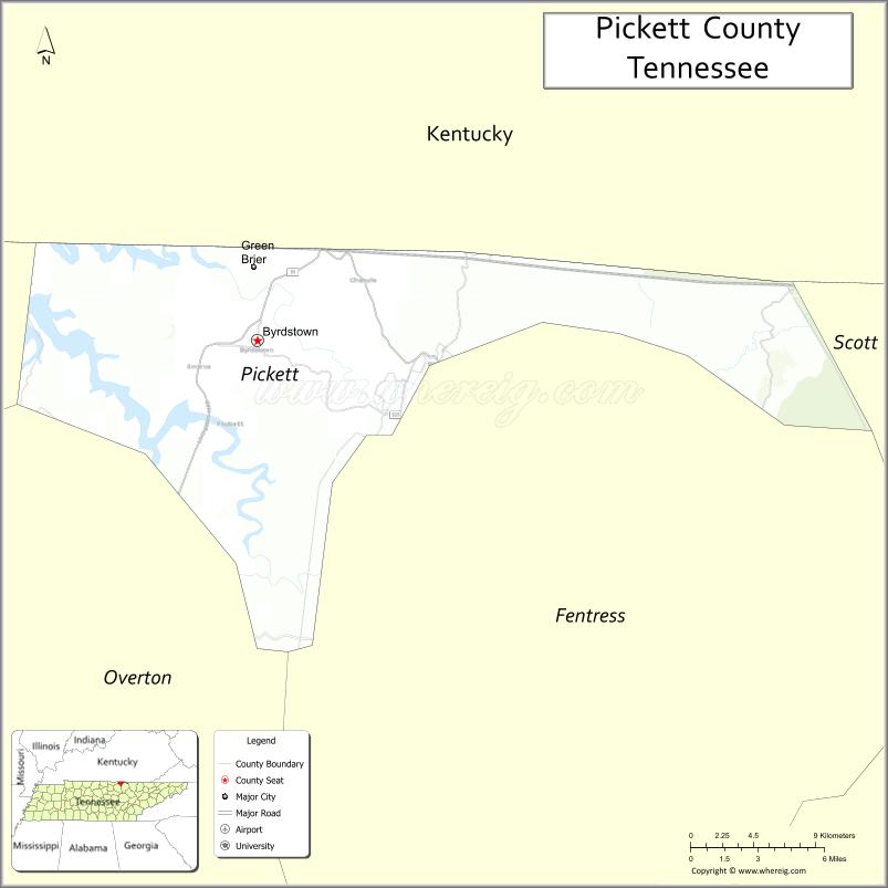
About Pickett County Map, Tennessee: The map showing the county boundary, county seat, major cities, highways and neighbouring counties.
Tennessee More Maps & Info
About Pickett County, Tennessee
Pickett County is a county located in the U.S. state of Tennessee. It's county seat is Byrdstown. As per 2020 census, the population of Pickett County is 5079 people and population density is square miles. According to the United States Census Bureau, the county has a total area of 163 sq mi (422 km2). Pickett County was established on 1879.
Pickett County Facts
| Continent | North America |
| Country | United States |
| State | Tennessee |
| County Seat | Byrdstown |
| Largest City/Town | Byrdstown |
| Established | 1879 |
| Total Area | 174 sq mi (451 sq km) |
| Land Area | 163 sq mi (422 sq km) |
| Water Area | 11 sq mi (29 sq km) |
| Population | 5,001 (Census 2020) |
| Population Density | 31 people per sq mi |
| Time Zone | Central Time Zone (CT) |
| Major Highways | TN-111, TN-42 |
| Neighboring Counties | Overton County, Fentress County, Clinton County (KY) |
| Famous For | Dale Hollow Lake, outdoor recreation, rural landscapes |
| Top Attractions | Dale Hollow Lake, Pickett State Park, Byrdstown Downtown |
| Official Website | https://www.pickettcountytn.gov |
Cities and Towns in Pickett County, Tennessee
- Byrdstown (county seat) – 800 (Census 2020)
Roads and Highways in Pickett County
Pickett County is served by state highways that connect it to nearby counties and scenic areas.
- State Route 111 – runs north–south, linking the county to Kentucky and central Tennessee
- State Route 42 – provides regional connectivity across the county
Neighboring Counties of Pickett County
- Clinton County, Kentucky (north)
- Fentress County (east)
- Overton County (south and west)
Top Attractions in Pickett County
Pickett County offers lakes, parks, and outdoor recreation opportunities.
- Dale Hollow Lake – known for fishing, boating, and houseboats
- Pickett State Park – offers hiking trails, camping, and scenic views
- Byrdstown Downtown – features small-town charm and local shops
- Pogue Creek Canyon State Natural Area – provides hiking and natural scenery
- Sunset Marina – a popular spot for boating and lake activities
- Obey River (nearby) – offers fishing and outdoor recreation
- Pickett County Courthouse – a historic landmark in Byrdstown
Distance from Pickett County to Nearby Cities
- Pickett County to Cookeville – 45 mi (72 km)
- Pickett County to Nashville – 110 mi (177 km)
- Pickett County to Knoxville – 120 mi (193 km)
- Pickett County to Lexington – 150 mi (241 km)
- Pickett County to Louisville – 170 mi (274 km)
FAQs about Pickett County
Pickett County is located in north-central Tennessee along the Kentucky border.
The county seat is Byrdstown.
It is known for Dale Hollow Lake, outdoor recreation, and scenic landscapes.
Main attractions include Dale Hollow Lake and Pickett State Park.
You can reach Pickett County via State Routes 111 and 42.
- Anderson County Map
- Bedford County Map
- Benton County Map
- Bledsoe County Map
- Blount County Map
- Bradley County Map
- Campbell County Map
- Cannon County Map
- Carroll County Map
- Carter County Map
- Cheatham County Map
- Chester County Map
- Claiborne County Map
- Clay County Map
- Cocke County Map
- Coffee County Map
- Crockett County Map
- Cumberland County Map
- Davidson County Map
- Decatur County Map
- DeKalb County Map
- Dickson County Map
- Dyer County Map
- Fayette County Map
- Fentress County Map
- Franklin County Map
- Gibson County Map
- Giles County Map
- Grainger County Map
- Greene County Map
- Grundy County Map
- Hamblen County Map
- Hamilton County Map
- Hancock County Map
- Hardeman County Map
- Hardin County Map
- Hawkins County Map
- Haywood County Map
- Henderson County Map
- Henry County Map
- Hickman County Map
- Houston County Map
- Humphreys County Map
- Jackson County Map
- Jefferson County Map
- Johnson County Map
- Knox County Map
- Lake County Map
- Lauderdale County Map
- Lawrence County Map
- Lewis County Map
- Lincoln County Map
- Loudon County Map
- McMinn County Map
- McNairy County Map
- Macon County Map
- Madison County Map
- Marion County Map
- Marshall County Map
- Maury County Map
- Meigs County Map
- Monroe County Map
- Montgomery County Map
- Moore County Map
- Morgan County Map
- Obion County Map
- Overton County Map
- Perry County Map
- Pickett County Map
- Polk County Map
- Putnam County Map
- Rhea County Map
- Roane County Map
- Robertson County Map
- Rutherford County Map
- Scott County Map
- Sequatchie County Map
- Sevier County Map
- Shelby County Map
- Smith County Map
- Stewart County Map
- Sullivan County Map
- Sumner County Map
- Tipton County Map
- Trousdale County Map
- Unicoi County Map
- Union County Map
- Van Buren County Map
- Warren County Map
- Washington County Map
- Wayne County Map
- Weakley County Map
- White County Map
- Williamson County Map
- Wilson County Map
- Alabama Counties
- Alaska boroughs
- Arizona Counties
- Arkansas Counties
- California County Map
- Colorado Counties
- Connecticut Counties
- Delaware Counties
- Florida County Map
- Georgia County Map
- Hawaii Counties
- Idaho Counties
- Illinois Counties
- Indiana Counties
- Iowa Counties
- Kansas Counties
- Kentucky Counties
- Louisiana Counties
- Maine Counties
- Maryland Counties
- Massachusetts Counties
- Michigan County Map
- Minnesota Counties
- Mississippi Counties
- Missouri Counties
- Montana Counties
- Nebraska Counties
- Nevada Counties
- New York Counties
- New Hampshire Counties
- New Jersey Counties
- New Mexico Counties
- North Carolina Counties
- North Dakota Counties
- Ohio County Map
- Oklahoma Counties
- Oregon Counties
- Pennsylvania Counties
- Rhode Island Counties
- South Carolina Counties
- South Dakota Counties
- Map of Tennessee
- Texas County Map
- Utah Counties
- Vermont Counties
- Virginia Counties
- Washington Counties
- West Virginia Counties
- Wisconsin Counties
- Wyoming Counties