Map of Warren County - Warren County is a county located in the U.S. state of Tennessee. Warren County Map showing cities, highways, important places and water bodies. Get Where is Warren County located in the map, major cities in Warren county, population, areas, and places of interest.
Map of Warren County, Tennessee
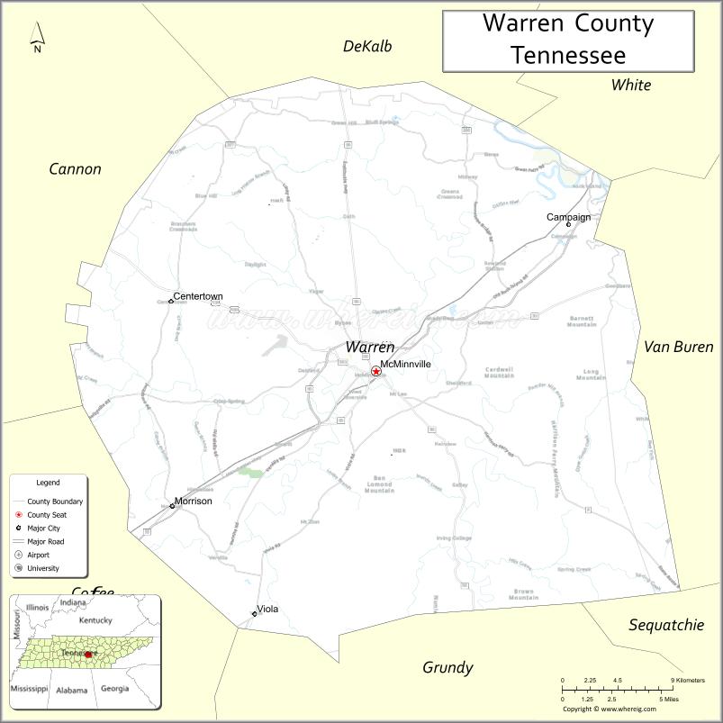
About Warren County Map, Tennessee: The map showing the county boundary, county seat, major cities, highways and neighbouring counties.
Tennessee More Maps & Info
About Warren County, Tennessee
Warren County is a county located in the U.S. state of Tennessee. It's county seat is McMinnville. As per 2020 census, the population of Warren County is 41523 people and population density is square miles. According to the United States Census Bureau, the county has a total area of 433 sq mi (1,121 km2). Warren County was established on 1807.
Warren County Facts
| Continent | North America |
| Country | United States |
| State | Tennessee |
| County Seat | McMinnville |
| Largest City/Town | McMinnville |
| Established | 1807 |
| Total Area | 433 sq mi |
| Land Area | 432 sq mi |
| Water Area | 1 sq mi |
| Population | 40,342 (Census 2020) |
| Population Density | 93 people per sq mi |
| Time Zone | Central (CST) |
| Major Highways | US-70S, TN-55, TN-56, TN-108 |
| Neighboring Counties | White County, Van Buren County, Grundy County, Coffee County, Cannon County, DeKalb County |
| Famous For | Nursery industry, Cumberland Plateau, scenic landscapes |
| Top Attractions | Rock Island State Park, Cumberland Caverns, Nursery Capital of the World |
| Official Website | https://www.warrencountytn.gov |
Cities and Towns in Warren County, Tennessee
- McMinnville (county seat) – 13,978 (Census 2020)
- Viola – 137 (Census 2020)
- Centertown – 300 (approx. community)
- Irving College – 0 (unincorporated community)
Roads and Highways in Warren County
Warren County is served by several highways that connect it to nearby cities across Middle Tennessee and the Cumberland Plateau.
- U.S. Route 70S (US-70S) – Runs east-west connecting McMinnville to Nashville and Sparta
- Tennessee State Route 55 (TN-55) – Connects the county to Manchester and McMinnville
- Tennessee State Route 56 (TN-56) – Links McMinnville to Smithville and Altamont
- Tennessee State Route 108 (TN-108) – Connects McMinnville to Spencer and the plateau region
Neighboring Counties of Warren County
- White County (north)
- Van Buren County (east)
- Grundy County (south)
- Coffee County (southwest)
- Cannon County (west)
- DeKalb County (northwest)
Top Attractions in Warren County
Warren County offers a mix of natural beauty, caves, and a strong agricultural heritage.
- Rock Island State Park – Known for waterfalls, hiking trails, and river views
- Cumberland Caverns – One of the longest caves in the U.S. with guided tours
- Falcon Rest Mansion – Historic Victorian mansion with tours
- Nursery Capital – Area known for plant nurseries and gardening
- Hickory Creek Nursery Area – Scenic farmland and plant industry hub
- Riverfront Park – Local park with walking paths and open spaces
- McMinnville Historic District – Features historic buildings and small-town charm
Distance from Warren County to Nearby Cities
- McMinnville to Nashville – 75 mi (121 km)
- McMinnville to Chattanooga – 80 mi (129 km)
- McMinnville to Knoxville – 140 mi (225 km)
- McMinnville to Cookeville – 35 mi (56 km)
- McMinnville to Manchester – 25 mi (40 km)
FAQs about Warren County
Warren County is known for its nursery industry, scenic landscapes, and outdoor attractions.
McMinnville is the county seat and largest city.
It has a large number of plant nurseries and is a major center for nursery production.
Visitors can explore parks, waterfalls, caves, and scenic countryside areas.
Yes, it is about 75 miles southeast of Nashville.
- Anderson County Map
- Bedford County Map
- Benton County Map
- Bledsoe County Map
- Blount County Map
- Bradley County Map
- Campbell County Map
- Cannon County Map
- Carroll County Map
- Carter County Map
- Cheatham County Map
- Chester County Map
- Claiborne County Map
- Clay County Map
- Cocke County Map
- Coffee County Map
- Crockett County Map
- Cumberland County Map
- Davidson County Map
- Decatur County Map
- DeKalb County Map
- Dickson County Map
- Dyer County Map
- Fayette County Map
- Fentress County Map
- Franklin County Map
- Gibson County Map
- Giles County Map
- Grainger County Map
- Greene County Map
- Grundy County Map
- Hamblen County Map
- Hamilton County Map
- Hancock County Map
- Hardeman County Map
- Hardin County Map
- Hawkins County Map
- Haywood County Map
- Henderson County Map
- Henry County Map
- Hickman County Map
- Houston County Map
- Humphreys County Map
- Jackson County Map
- Jefferson County Map
- Johnson County Map
- Knox County Map
- Lake County Map
- Lauderdale County Map
- Lawrence County Map
- Lewis County Map
- Lincoln County Map
- Loudon County Map
- McMinn County Map
- McNairy County Map
- Macon County Map
- Madison County Map
- Marion County Map
- Marshall County Map
- Maury County Map
- Meigs County Map
- Monroe County Map
- Montgomery County Map
- Moore County Map
- Morgan County Map
- Obion County Map
- Overton County Map
- Perry County Map
- Pickett County Map
- Polk County Map
- Putnam County Map
- Rhea County Map
- Roane County Map
- Robertson County Map
- Rutherford County Map
- Scott County Map
- Sequatchie County Map
- Sevier County Map
- Shelby County Map
- Smith County Map
- Stewart County Map
- Sullivan County Map
- Sumner County Map
- Tipton County Map
- Trousdale County Map
- Unicoi County Map
- Union County Map
- Van Buren County Map
- Warren County Map
- Washington County Map
- Wayne County Map
- Weakley County Map
- White County Map
- Williamson County Map
- Wilson County Map
- Alabama Counties
- Alaska boroughs
- Arizona Counties
- Arkansas Counties
- California County Map
- Colorado Counties
- Connecticut Counties
- Delaware Counties
- Florida County Map
- Georgia County Map
- Hawaii Counties
- Idaho Counties
- Illinois Counties
- Indiana Counties
- Iowa Counties
- Kansas Counties
- Kentucky Counties
- Louisiana Counties
- Maine Counties
- Maryland Counties
- Massachusetts Counties
- Michigan County Map
- Minnesota Counties
- Mississippi Counties
- Missouri Counties
- Montana Counties
- Nebraska Counties
- Nevada Counties
- New York Counties
- New Hampshire Counties
- New Jersey Counties
- New Mexico Counties
- North Carolina Counties
- North Dakota Counties
- Ohio County Map
- Oklahoma Counties
- Oregon Counties
- Pennsylvania Counties
- Rhode Island Counties
- South Carolina Counties
- South Dakota Counties
- Map of Tennessee
- Texas County Map
- Utah Counties
- Vermont Counties
- Virginia Counties
- Washington Counties
- West Virginia Counties
- Wisconsin Counties
- Wyoming Counties