Map of Davidson County - Davidson County is a county located in the U.S. state of Tennessee. Davidson County Map showing cities, highways, important places and water bodies. Get Where is Davidson County located in the map, major cities in Davidson county, population, areas, and places of interest.
Map of Davidson County, Tennessee
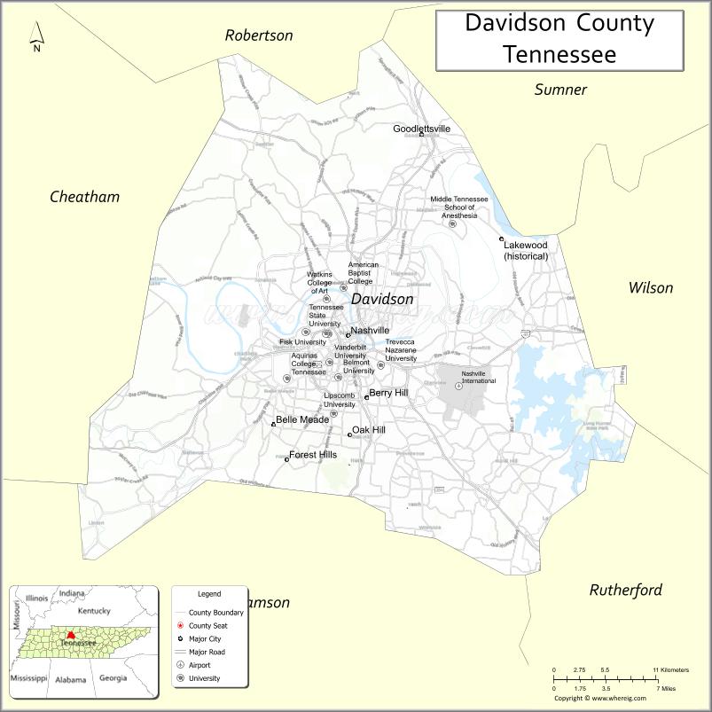
About Davidson County Map, Tennessee: The map showing the county boundary, county seat, major cities, highways and neighbouring counties.
Tennessee More Maps & Info
About Davidson County, Tennessee
Davidson County is a county located in the U.S. state of Tennessee. It's county seat is Nashville. As per 2020 census, the population of Davidson County is 703953 people and population density is square miles. According to the United States Census Bureau, the county has a total area of 502 sq mi (1,300 km2). Davidson County was established on 1783.
Davidson County Facts
| Continent | North America |
| Country | United States |
| State | Tennessee |
| County Seat | Nashville |
| Largest City/Town | Nashville |
| Established | 1783 |
| Total Area | 526 sq mi (1,362 sq km) |
| Land Area | 504 sq mi (1,305 sq km) |
| Water Area | 22 sq mi (57 sq km) |
| Population | 715,884 (Census 2020) |
| Population Density | 1,421 people per sq mi |
| Time Zone | Central Time Zone (CT) |
| Major Highways | I-40, I-24, I-65, I-440, US-31, US-41, US-70 |
| Neighboring Counties | Robertson County, Sumner County, Wilson County, Rutherford County, Williamson County, Cheatham County |
| Famous For | Nashville, country music, live entertainment |
| Top Attractions | Grand Ole Opry, Broadway, Country Music Hall of Fame, Centennial Park |
| Official Website | https://www.nashville.gov |
Cities and Towns in Davidson County, Tennessee
- Nashville (county seat) – 689,447 (Census 2020)
- Forest Hills – 5,362 (Census 2020)
- Oak Hill – 4,744 (Census 2020)
- Berry Hill – 2,112 (Census 2020)
Roads and Highways in Davidson County
Davidson County is a major transportation hub with several interstates and highways connecting it to cities across Tennessee and beyond.
- Interstate 40 (I-40) – runs east–west, connecting Nashville to Memphis and Knoxville
- Interstate 24 (I-24) – runs northwest–southeast, linking Nashville to Clarksville and Chattanooga
- Interstate 65 (I-65) – runs north–south, connecting Nashville to Louisville and Birmingham
- Interstate 440 (I-440) – bypass loop around central Nashville
- U.S. Route 31 – connects Nashville to surrounding communities
- U.S. Route 41 – runs through the county linking nearby towns
- U.S. Route 70 – provides east–west access across the region
Neighboring Counties of Davidson County
- Robertson County (northwest)
- Sumner County (north)
- Wilson County (east)
- Rutherford County (southeast)
- Williamson County (southwest)
- Cheatham County (west)
Top Attractions in Davidson County
Davidson County is home to Nashville, offering world-famous music, culture, and entertainment.
- Grand Ole Opry – a legendary venue for country music performances
- Broadway – a lively street filled with music venues and nightlife
- Country Music Hall of Fame and Museum – showcases the history of country music
- Centennial Park – features the Parthenon replica and green space
- Ryman Auditorium – historic venue known as the "Mother Church of Country Music"
- Nashville Zoo – a family-friendly attraction with a wide range of animals
- The Parthenon – a full-scale replica of the ancient Greek structure
- Johnny Cash Museum – dedicated to the life and career of the famous singer
Distance from Davidson County to Nearby Cities
- Davidson County to Memphis – 210 mi (338 km)
- Davidson County to Knoxville – 180 mi (290 km)
- Davidson County to Chattanooga – 135 mi (217 km)
- Davidson County to Louisville – 175 mi (282 km)
- Davidson County to Atlanta – 250 mi (402 km)
FAQs about Davidson County
Davidson County is located in central Tennessee and includes the city of Nashville.
The county seat is Nashville.
It is known for Nashville, country music, and live entertainment.
Main attractions include the Grand Ole Opry, Broadway, and the Country Music Hall of Fame.
You can reach Davidson County via major interstates like I-40, I-24, and I-65.
- Anderson County Map
- Bedford County Map
- Benton County Map
- Bledsoe County Map
- Blount County Map
- Bradley County Map
- Campbell County Map
- Cannon County Map
- Carroll County Map
- Carter County Map
- Cheatham County Map
- Chester County Map
- Claiborne County Map
- Clay County Map
- Cocke County Map
- Coffee County Map
- Crockett County Map
- Cumberland County Map
- Davidson County Map
- Decatur County Map
- DeKalb County Map
- Dickson County Map
- Dyer County Map
- Fayette County Map
- Fentress County Map
- Franklin County Map
- Gibson County Map
- Giles County Map
- Grainger County Map
- Greene County Map
- Grundy County Map
- Hamblen County Map
- Hamilton County Map
- Hancock County Map
- Hardeman County Map
- Hardin County Map
- Hawkins County Map
- Haywood County Map
- Henderson County Map
- Henry County Map
- Hickman County Map
- Houston County Map
- Humphreys County Map
- Jackson County Map
- Jefferson County Map
- Johnson County Map
- Knox County Map
- Lake County Map
- Lauderdale County Map
- Lawrence County Map
- Lewis County Map
- Lincoln County Map
- Loudon County Map
- McMinn County Map
- McNairy County Map
- Macon County Map
- Madison County Map
- Marion County Map
- Marshall County Map
- Maury County Map
- Meigs County Map
- Monroe County Map
- Montgomery County Map
- Moore County Map
- Morgan County Map
- Obion County Map
- Overton County Map
- Perry County Map
- Pickett County Map
- Polk County Map
- Putnam County Map
- Rhea County Map
- Roane County Map
- Robertson County Map
- Rutherford County Map
- Scott County Map
- Sequatchie County Map
- Sevier County Map
- Shelby County Map
- Smith County Map
- Stewart County Map
- Sullivan County Map
- Sumner County Map
- Tipton County Map
- Trousdale County Map
- Unicoi County Map
- Union County Map
- Van Buren County Map
- Warren County Map
- Washington County Map
- Wayne County Map
- Weakley County Map
- White County Map
- Williamson County Map
- Wilson County Map
- Alabama Counties
- Alaska boroughs
- Arizona Counties
- Arkansas Counties
- California County Map
- Colorado Counties
- Connecticut Counties
- Delaware Counties
- Florida County Map
- Georgia County Map
- Hawaii Counties
- Idaho Counties
- Illinois Counties
- Indiana Counties
- Iowa Counties
- Kansas Counties
- Kentucky Counties
- Louisiana Counties
- Maine Counties
- Maryland Counties
- Massachusetts Counties
- Michigan County Map
- Minnesota Counties
- Mississippi Counties
- Missouri Counties
- Montana Counties
- Nebraska Counties
- Nevada Counties
- New York Counties
- New Hampshire Counties
- New Jersey Counties
- New Mexico Counties
- North Carolina Counties
- North Dakota Counties
- Ohio County Map
- Oklahoma Counties
- Oregon Counties
- Pennsylvania Counties
- Rhode Island Counties
- South Carolina Counties
- South Dakota Counties
- Map of Tennessee
- Texas County Map
- Utah Counties
- Vermont Counties
- Virginia Counties
- Washington Counties
- West Virginia Counties
- Wisconsin Counties
- Wyoming Counties