Map of Marshall County - Marshall County is a county located in the U.S. state of Tennessee. Marshall County Map showing cities, highways, important places and water bodies. Get Where is Marshall County located in the map, major cities in Marshall county, population, areas, and places of interest.
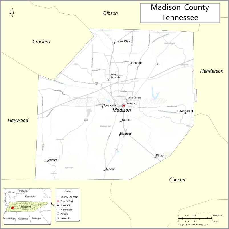
Map of Madison County, Tennessee
About Marshall County Map, Tennessee: The map showing the county boundary, county seat, major cities, highways and neighbouring counties.
Tennessee More Maps & Info
About Madison County, Tennessee
Madison County is a county located in the U.S. state of Tennessee. It's county seat is Jackson. As per 2020 census, the population of Madison County is 98775 people and population density is square miles. According to the United States Census Bureau, the county has a total area of 557 sq mi (1,443 km2). Madison County was established on 1821.
Madison County Facts
| Continent | North America |
| Country | United States |
| State | Tennessee |
| County Seat | Jackson |
| Largest City/Town | Jackson |
| Established | 1821 |
| Total Area | 558 sq mi (1,445 sq km) |
| Land Area | 557 sq mi (1,442 sq km) |
| Water Area | 1 sq mi (3 sq km) |
| Population | 98,823 (Census 2020) |
| Population Density | 177 people per sq mi |
| Time Zone | Central Time Zone (CT) |
| Major Highways | I-40, US-45, US-70, TN-20 |
| Neighboring Counties | Carroll County, Henderson County, Chester County, Hardeman County, Crockett County, Gibson County |
| Famous For | Jackson city, Casey Jones legend, manufacturing |
| Top Attractions | Casey Jones Village, Cypress Grove Nature Park, Rusty’s TV and Movie Car Museum |
| Official Website | https://www.madisontn.org |
Cities and Towns in Madison County, Tennessee
- Jackson (county seat) – 68,205 (Census 2020)
- Medina – 4,500 (Census 2020)
- Three Way – 1,800 (Census 2020)
- Pinson – 1,200 (Census 2020)
Roads and Highways in Madison County
Madison County is a key transportation hub in West Tennessee with major highways connecting the region.
- Interstate 40 (I-40) – runs east–west, connecting Memphis and Nashville
- U.S. Route 45 – runs north–south, linking Jackson to Kentucky and Mississippi
- U.S. Route 70 – parallels I-40, connecting local communities
- State Route 20 – provides additional access across the county
Neighboring Counties of Madison County
- Carroll County (north)
- Gibson County (northwest)
- Crockett County (west)
- Henderson County (east)
- Chester County (south)
- Hardeman County (southwest)
Top Attractions in Madison County
Madison County offers cultural attractions, parks, and historic sites.
- Casey Jones Village – a popular attraction celebrating the famous railroad engineer
- Cypress Grove Nature Park – offers walking trails, wildlife viewing, and scenic landscapes
- Rusty’s TV and Movie Car Museum – features vehicles from films and television
- Jackson Downtown Square – offers shopping, dining, and local events
- International Rock-A-Billy Hall of Fame – celebrates rockabilly music history
- Muse Park – provides recreational facilities and open space
- West Tennessee Healthcare Sportsplex – hosts sports events and activities
Distance from Madison County to Nearby Cities
- Madison County to Memphis – 85 mi (137 km)
- Madison County to Nashville – 125 mi (201 km)
- Madison County to Clarksville – 130 mi (209 km)
- Madison County to Birmingham – 200 mi (322 km)
- Madison County to Little Rock – 170 mi (274 km)
FAQs about Madison County
Madison County is located in western Tennessee in the United States.
The county seat is Jackson.
It is known for the city of Jackson, the Casey Jones legend, and manufacturing.
Main attractions include Casey Jones Village and Cypress Grove Nature Park.
You can reach Madison County via Interstate 40 and U.S. Routes 45 and 70.
- Anderson County Map
- Bedford County Map
- Benton County Map
- Bledsoe County Map
- Blount County Map
- Bradley County Map
- Campbell County Map
- Cannon County Map
- Carroll County Map
- Carter County Map
- Cheatham County Map
- Chester County Map
- Claiborne County Map
- Clay County Map
- Cocke County Map
- Coffee County Map
- Crockett County Map
- Cumberland County Map
- Davidson County Map
- Decatur County Map
- DeKalb County Map
- Dickson County Map
- Dyer County Map
- Fayette County Map
- Fentress County Map
- Franklin County Map
- Gibson County Map
- Giles County Map
- Grainger County Map
- Greene County Map
- Grundy County Map
- Hamblen County Map
- Hamilton County Map
- Hancock County Map
- Hardeman County Map
- Hardin County Map
- Hawkins County Map
- Haywood County Map
- Henderson County Map
- Henry County Map
- Hickman County Map
- Houston County Map
- Humphreys County Map
- Jackson County Map
- Jefferson County Map
- Johnson County Map
- Knox County Map
- Lake County Map
- Lauderdale County Map
- Lawrence County Map
- Lewis County Map
- Lincoln County Map
- Loudon County Map
- McMinn County Map
- McNairy County Map
- Macon County Map
- Madison County Map
- Marion County Map
- Marshall County Map
- Maury County Map
- Meigs County Map
- Monroe County Map
- Montgomery County Map
- Moore County Map
- Morgan County Map
- Obion County Map
- Overton County Map
- Perry County Map
- Pickett County Map
- Polk County Map
- Putnam County Map
- Rhea County Map
- Roane County Map
- Robertson County Map
- Rutherford County Map
- Scott County Map
- Sequatchie County Map
- Sevier County Map
- Shelby County Map
- Smith County Map
- Stewart County Map
- Sullivan County Map
- Sumner County Map
- Tipton County Map
- Trousdale County Map
- Unicoi County Map
- Union County Map
- Van Buren County Map
- Warren County Map
- Washington County Map
- Wayne County Map
- Weakley County Map
- White County Map
- Williamson County Map
- Wilson County Map
- Alabama Counties
- Alaska boroughs
- Arizona Counties
- Arkansas Counties
- California County Map
- Colorado Counties
- Connecticut Counties
- Delaware Counties
- Florida County Map
- Georgia County Map
- Hawaii Counties
- Idaho Counties
- Illinois Counties
- Indiana Counties
- Iowa Counties
- Kansas Counties
- Kentucky Counties
- Louisiana Counties
- Maine Counties
- Maryland Counties
- Massachusetts Counties
- Michigan County Map
- Minnesota Counties
- Mississippi Counties
- Missouri Counties
- Montana Counties
- Nebraska Counties
- Nevada Counties
- New York Counties
- New Hampshire Counties
- New Jersey Counties
- New Mexico Counties
- North Carolina Counties
- North Dakota Counties
- Ohio County Map
- Oklahoma Counties
- Oregon Counties
- Pennsylvania Counties
- Rhode Island Counties
- South Carolina Counties
- South Dakota Counties
- Map of Tennessee
- Texas County Map
- Utah Counties
- Vermont Counties
- Virginia Counties
- Washington Counties
- West Virginia Counties
- Wisconsin Counties
- Wyoming Counties