Map of Bedford County - Bedford County is a county located in the U.S. state of Tennessee. Bedford County Map showing cities, highways, important places and water bodies. Get Where is Bedford County located in the map, major cities in Bedford county, population, areas, and places of interest.
Map of Bedford County, Tennessee
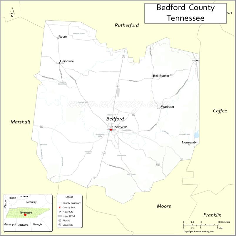
About Bedford County Map, Tennessee: The map showing the county boundary, county seat, major cities, highways and neighbouring counties.
Tennessee More Maps & Info
About Bedford County, Tennessee
Bedford County is a county located in the U.S. state of Tennessee. It's county seat is Shelbyville. As per 2020 census, the population of Bedford County is 51119 people and population density is square miles. According to the United States Census Bureau, the county has a total area of 474 sq mi (1,228 km2). Bedford County was established on 1807.
Bedford County Facts
| Continent | North America |
| Country | United States |
| State | Tennessee |
| County Seat | Shelbyville |
| Largest City/Town | Shelbyville |
| Established | 1807 |
| Total Area | 475 sq mi (1,230 sq km) |
| Land Area | 474 sq mi (1,228 sq km) |
| Water Area | 1 sq mi (2 sq km) |
| Population | 50,237 (Census 2020) |
| Population Density | 106 people per sq mi |
| Time Zone | Central Time Zone (CT) |
| Major Highways | US-231, US-41A, TN-64, TN-82 |
| Neighboring Counties | Rutherford County, Coffee County, Moore County, Lincoln County, Marshall County, Cannon County |
| Famous For | Tennessee Walking Horse industry, Walking Horse National Celebration |
| Top Attractions | Tennessee Walking Horse National Celebration Grounds, Shelbyville Historic District, H.V. Griffin Park |
| Official Website | https://www.bedfordcountytn.gov |
Cities and Towns in Bedford County, Tennessee
- Shelbyville (county seat) – 23,106 (Census 2020)
- Bell Buckle – 500 (Census 2020)
- Wartrace – 764 (Census 2020)
- Flat Creek (CDP) – 1,300 (Census 2020)
Roads and Highways in Bedford County
Bedford County is connected by key highways that link it to central Tennessee cities and nearby rural areas.
- U.S. Route 231 – runs north–south, connecting to Murfreesboro and Fayetteville
- U.S. Route 41A – runs northwest–southeast, linking to Nashville and Tullahoma
- State Route 64 – runs east–west, connecting to Shelbyville and neighboring counties
- State Route 82 – provides regional access between Shelbyville and Lynchburg
Neighboring Counties of Bedford County
- Rutherford County (north)
- Cannon County (northeast)
- Coffee County (east)
- Moore County (south)
- Lincoln County (southwest)
- Marshall County (west)
Top Attractions in Bedford County
Bedford County offers a mix of horse culture, small-town charm, and outdoor spaces to enjoy.
- Tennessee Walking Horse National Celebration Grounds – hosts the famous annual horse show
- Shelbyville Historic District – features historic buildings and local shops
- H.V. Griffin Park – a large park with trails, playgrounds, and sports areas
- Bell Buckle Historic District – a charming town known for arts, crafts, and festivals
- Duck River – popular for kayaking, fishing, and scenic views
- Wartrace Historic District – known for its ties to horse training and history
- Jernigan Field – a local sports and recreation area
- Bedford County Arts Council – showcases local art and events
Distance from Bedford County to Nearby Cities
- Bedford County to Nashville – 55 mi (89 km)
- Bedford County to Murfreesboro – 30 mi (48 km)
- Bedford County to Chattanooga – 90 mi (145 km)
- Bedford County to Huntsville – 70 mi (113 km)
- Bedford County to Knoxville – 180 mi (290 km)
FAQs about Bedford County
Bedford County is located in southern Middle Tennessee in the United States.
The county seat is Shelbyville.
It is best known for the Tennessee Walking Horse industry and its annual celebration.
Main attractions include the Walking Horse Celebration Grounds, Bell Buckle, and local parks.
You can reach Bedford County via U.S. Routes 231 and 41A or several state highways.
- Anderson County Map
- Bedford County Map
- Benton County Map
- Bledsoe County Map
- Blount County Map
- Bradley County Map
- Campbell County Map
- Cannon County Map
- Carroll County Map
- Carter County Map
- Cheatham County Map
- Chester County Map
- Claiborne County Map
- Clay County Map
- Cocke County Map
- Coffee County Map
- Crockett County Map
- Cumberland County Map
- Davidson County Map
- Decatur County Map
- DeKalb County Map
- Dickson County Map
- Dyer County Map
- Fayette County Map
- Fentress County Map
- Franklin County Map
- Gibson County Map
- Giles County Map
- Grainger County Map
- Greene County Map
- Grundy County Map
- Hamblen County Map
- Hamilton County Map
- Hancock County Map
- Hardeman County Map
- Hardin County Map
- Hawkins County Map
- Haywood County Map
- Henderson County Map
- Henry County Map
- Hickman County Map
- Houston County Map
- Humphreys County Map
- Jackson County Map
- Jefferson County Map
- Johnson County Map
- Knox County Map
- Lake County Map
- Lauderdale County Map
- Lawrence County Map
- Lewis County Map
- Lincoln County Map
- Loudon County Map
- McMinn County Map
- McNairy County Map
- Macon County Map
- Madison County Map
- Marion County Map
- Marshall County Map
- Maury County Map
- Meigs County Map
- Monroe County Map
- Montgomery County Map
- Moore County Map
- Morgan County Map
- Obion County Map
- Overton County Map
- Perry County Map
- Pickett County Map
- Polk County Map
- Putnam County Map
- Rhea County Map
- Roane County Map
- Robertson County Map
- Rutherford County Map
- Scott County Map
- Sequatchie County Map
- Sevier County Map
- Shelby County Map
- Smith County Map
- Stewart County Map
- Sullivan County Map
- Sumner County Map
- Tipton County Map
- Trousdale County Map
- Unicoi County Map
- Union County Map
- Van Buren County Map
- Warren County Map
- Washington County Map
- Wayne County Map
- Weakley County Map
- White County Map
- Williamson County Map
- Wilson County Map
- Alabama Counties
- Alaska boroughs
- Arizona Counties
- Arkansas Counties
- California County Map
- Colorado Counties
- Connecticut Counties
- Delaware Counties
- Florida County Map
- Georgia County Map
- Hawaii Counties
- Idaho Counties
- Illinois Counties
- Indiana Counties
- Iowa Counties
- Kansas Counties
- Kentucky Counties
- Louisiana Counties
- Maine Counties
- Maryland Counties
- Massachusetts Counties
- Michigan County Map
- Minnesota Counties
- Mississippi Counties
- Missouri Counties
- Montana Counties
- Nebraska Counties
- Nevada Counties
- New York Counties
- New Hampshire Counties
- New Jersey Counties
- New Mexico Counties
- North Carolina Counties
- North Dakota Counties
- Ohio County Map
- Oklahoma Counties
- Oregon Counties
- Pennsylvania Counties
- Rhode Island Counties
- South Carolina Counties
- South Dakota Counties
- Map of Tennessee
- Texas County Map
- Utah Counties
- Vermont Counties
- Virginia Counties
- Washington Counties
- West Virginia Counties
- Wisconsin Counties
- Wyoming Counties