Map of Bradley County - Bradley County is a county located in the U.S. state of Tennessee. Bradley County Map showing cities, highways, important places and water bodies. Get Where is Bradley County located in the map, major cities in Bradley county, population, areas, and places of interest.
Map of Bradley County, Tennessee
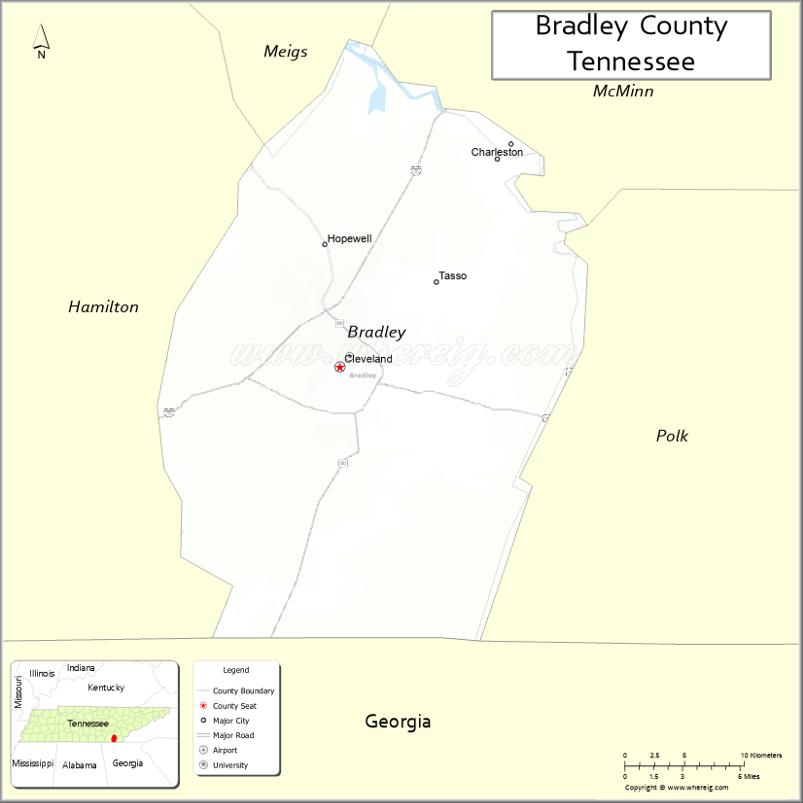
About Bradley County Map, Tennessee: The map showing the county boundary, county seat, major cities, highways and neighbouring counties.
Tennessee More Maps & Info
About Bradley County, Tennessee
Bradley County is a county located in the U.S. state of Tennessee. It's county seat is Cleveland. As per 2020 census, the population of Bradley County is 110162 people and population density is square miles. According to the United States Census Bureau, the county has a total area of 329 sq mi (852 km2). Bradley County was established on 1836.
Bradley County Facts
| Continent | North America |
| Country | United States |
| State | Tennessee |
| County Seat | Cleveland |
| Largest City/Town | Cleveland |
| Established | 1836 |
| Total Area | 336 sq mi (870 sq km) |
| Land Area | 329 sq mi (852 sq km) |
| Water Area | 7 sq mi (18 sq km) |
| Population | 108,620 (Census 2020) |
| Population Density | 330 people per sq mi |
| Time Zone | Eastern Time Zone (ET) |
| Major Highways | I-75, US-11, US-64, US-74, TN-60 |
| Neighboring Counties | McMinn County, Polk County, Hamilton County, Meigs County, Rhea County |
| Famous For | Lee University, Cherokee National Forest access, manufacturing |
| Top Attractions | Red Clay State Historic Park, Cleveland Greenway, Museum Center at 5ive Points |
| Official Website | https://www.bradleycountytn.gov |
Cities and Towns in Bradley County, Tennessee
- Cleveland (county seat) – 47,356 (Census 2020)
- Charleston – 651 (Census 2020)
- Hopewell (CDP) – 1,900 (Census 2020)
- Wildwood Lake (CDP) – 3,050 (Census 2020)
Roads and Highways in Bradley County
Bradley County is well connected by major interstates and highways that link it to Chattanooga and other regional cities.
- Interstate 75 (I-75) – runs north–south, connecting Knoxville and Chattanooga
- U.S. Route 11 – runs parallel to I-75, linking Cleveland with nearby towns
- U.S. Route 64 – runs east–west, connecting to Polk County and Hamilton County
- U.S. Route 74 – provides access toward North Carolina and surrounding regions
- State Route 60 – connects Cleveland to Dayton and McMinn County
Neighboring Counties of Bradley County
- McMinn County (north)
- Meigs County (northwest)
- Rhea County (west)
- Hamilton County (southwest)
- Polk County (south and east)
Top Attractions in Bradley County
Bradley County offers a mix of history, outdoor spaces, and local attractions centered around the city of Cleveland.
- Red Clay State Historic Park – a historic Cherokee site with trails and picnic areas
- Cleveland Greenway – a scenic path for walking, biking, and running
- Museum Center at 5ive Points – features exhibits on local history and culture
- Hiwassee River – popular for kayaking, fishing, and rafting
- Bradley Square Mall – a shopping destination in Cleveland
- Tinsley Park – a large park with sports fields and walking trails
- Ocoee River (nearby) – known for whitewater rafting and outdoor adventure
- Lee University Campus – a notable local landmark and educational center
Distance from Bradley County to Nearby Cities
- Bradley County to Chattanooga – 30 mi (48 km)
- Bradley County to Knoxville – 80 mi (129 km)
- Bradley County to Nashville – 150 mi (241 km)
- Bradley County to Atlanta – 110 mi (177 km)
- Bradley County to Asheville – 120 mi (193 km)
FAQs about Bradley County
Bradley County is located in southeastern Tennessee in the United States.
The county seat is Cleveland.
It is known for Cleveland, Lee University, and access to outdoor recreation areas.
Main attractions include Red Clay State Historic Park, the Cleveland Greenway, and the Hiwassee River.
You can reach Bradley County via Interstate 75 and several U.S. highways connecting it to nearby cities.
- Anderson County Map
- Bedford County Map
- Benton County Map
- Bledsoe County Map
- Blount County Map
- Bradley County Map
- Campbell County Map
- Cannon County Map
- Carroll County Map
- Carter County Map
- Cheatham County Map
- Chester County Map
- Claiborne County Map
- Clay County Map
- Cocke County Map
- Coffee County Map
- Crockett County Map
- Cumberland County Map
- Davidson County Map
- Decatur County Map
- DeKalb County Map
- Dickson County Map
- Dyer County Map
- Fayette County Map
- Fentress County Map
- Franklin County Map
- Gibson County Map
- Giles County Map
- Grainger County Map
- Greene County Map
- Grundy County Map
- Hamblen County Map
- Hamilton County Map
- Hancock County Map
- Hardeman County Map
- Hardin County Map
- Hawkins County Map
- Haywood County Map
- Henderson County Map
- Henry County Map
- Hickman County Map
- Houston County Map
- Humphreys County Map
- Jackson County Map
- Jefferson County Map
- Johnson County Map
- Knox County Map
- Lake County Map
- Lauderdale County Map
- Lawrence County Map
- Lewis County Map
- Lincoln County Map
- Loudon County Map
- McMinn County Map
- McNairy County Map
- Macon County Map
- Madison County Map
- Marion County Map
- Marshall County Map
- Maury County Map
- Meigs County Map
- Monroe County Map
- Montgomery County Map
- Moore County Map
- Morgan County Map
- Obion County Map
- Overton County Map
- Perry County Map
- Pickett County Map
- Polk County Map
- Putnam County Map
- Rhea County Map
- Roane County Map
- Robertson County Map
- Rutherford County Map
- Scott County Map
- Sequatchie County Map
- Sevier County Map
- Shelby County Map
- Smith County Map
- Stewart County Map
- Sullivan County Map
- Sumner County Map
- Tipton County Map
- Trousdale County Map
- Unicoi County Map
- Union County Map
- Van Buren County Map
- Warren County Map
- Washington County Map
- Wayne County Map
- Weakley County Map
- White County Map
- Williamson County Map
- Wilson County Map
- Alabama Counties
- Alaska boroughs
- Arizona Counties
- Arkansas Counties
- California County Map
- Colorado Counties
- Connecticut Counties
- Delaware Counties
- Florida County Map
- Georgia County Map
- Hawaii Counties
- Idaho Counties
- Illinois Counties
- Indiana Counties
- Iowa Counties
- Kansas Counties
- Kentucky Counties
- Louisiana Counties
- Maine Counties
- Maryland Counties
- Massachusetts Counties
- Michigan County Map
- Minnesota Counties
- Mississippi Counties
- Missouri Counties
- Montana Counties
- Nebraska Counties
- Nevada Counties
- New York Counties
- New Hampshire Counties
- New Jersey Counties
- New Mexico Counties
- North Carolina Counties
- North Dakota Counties
- Ohio County Map
- Oklahoma Counties
- Oregon Counties
- Pennsylvania Counties
- Rhode Island Counties
- South Carolina Counties
- South Dakota Counties
- Map of Tennessee
- Texas County Map
- Utah Counties
- Vermont Counties
- Virginia Counties
- Washington Counties
- West Virginia Counties
- Wisconsin Counties
- Wyoming Counties