Map of Roane County - Roane County is a county located in the U.S. state of Tennessee. Roane County Map showing cities, highways, important places and water bodies. Get Where is Roane County located in the map, major cities in Roane county, population, areas, and places of interest.
Map of Roane County, Tennessee
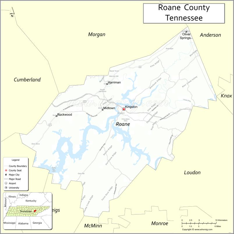
About Roane County Map, Tennessee: The map showing the county boundary, county seat, major cities, highways and neighbouring counties.
Tennessee More Maps & Info
About Roane County, Tennessee
Roane County is a county located in the U.S. state of Tennessee. It's county seat is Kingston. As per 2020 census, the population of Roane County is 53992 people and population density is square miles. According to the United States Census Bureau, the county has a total area of 361 sq mi (935 km2). Roane County was established on 1801.
Roane County Facts
| Continent | North America |
| Country | United States |
| State | Tennessee |
| County Seat | Kingston |
| Largest City/Town | Oak Ridge (partly) |
| Established | 1801 |
| Total Area | 395 sq mi |
| Land Area | 361 sq mi |
| Water Area | 34 sq mi |
| Population | 53,404 (Census 2020) |
| Population Density | 148 people per sq mi |
| Time Zone | Eastern (EST) |
| Major Highways | I-40, I-75, US-70, TN-58, TN-61 |
| Neighboring Counties | Morgan County, Anderson County, Loudon County, Rhea County, Meigs County |
| Famous For | Oak Ridge history, Tennessee River, outdoor recreation |
| Top Attractions | Fort Southwest Point, Watts Bar Lake, Roane State Park |
| Official Website | https://www.roanecountytn.gov |
Cities and Towns in Roane County, Tennessee
- Kingston (county seat) – 6,110 (Census 2020)
- Harriman – 6,389 (Census 2020)
- Rockwood – 5,562 (Census 2020)
- Oak Ridge (partly) – 31,402 (Census 2020)
Roads and Highways in Roane County
Roane County is well connected by major interstates and state routes that link it to Knoxville, Chattanooga, and surrounding counties.
- Interstate 40 (I-40) – Runs east-west connecting Knoxville to Nashville
- Interstate 75 (I-75) – North-south route linking Michigan to Florida through East Tennessee
- U.S. Route 70 (US-70) – Parallels I-40 and connects local communities
- Tennessee State Route 58 (TN-58) – Connects Kingston to Chattanooga
- Tennessee State Route 61 (TN-61) – Links Harriman to Oliver Springs
Neighboring Counties of Roane County
- Morgan County (north)
- Anderson County (northeast)
- Loudon County (south)
- Rhea County (southwest)
- Meigs County (west)
Top Attractions in Roane County
Roane County offers a mix of history, lakes, and outdoor spaces, making it a great spot for both learning and relaxation.
- Fort Southwest Point – Historic site marking early frontier history
- Watts Bar Lake – Popular for boating, fishing, and camping
- Roane State Park – Scenic park with trails and picnic areas
- Kingston Waterfront – Relaxing views along the Tennessee River
- Harriman Riverfront Park – Great for walking and family outings
- Rockwood Marina – Ideal for lake access and boating activities
- Oak Ridge History Area – Nearby sites related to the Manhattan Project
Distance from Roane County to Nearby Cities
- Kingston to Knoxville – 30 mi (48 km)
- Kingston to Chattanooga – 105 mi (169 km)
- Kingston to Nashville – 160 mi (257 km)
- Kingston to Oak Ridge – 12 mi (19 km)
- Kingston to Crossville – 45 mi (72 km)
FAQs about Roane County
Roane County is known for its connection to Oak Ridge and its role in early U.S. history and science.
Kingston is the county seat of Roane County.
Interstates 40 and 75 are the main highways serving the county.
Watts Bar Lake and local parks offer boating, fishing, and outdoor recreation.
Yes, it is about 30 miles west of Knoxville.
- Anderson County Map
- Bedford County Map
- Benton County Map
- Bledsoe County Map
- Blount County Map
- Bradley County Map
- Campbell County Map
- Cannon County Map
- Carroll County Map
- Carter County Map
- Cheatham County Map
- Chester County Map
- Claiborne County Map
- Clay County Map
- Cocke County Map
- Coffee County Map
- Crockett County Map
- Cumberland County Map
- Davidson County Map
- Decatur County Map
- DeKalb County Map
- Dickson County Map
- Dyer County Map
- Fayette County Map
- Fentress County Map
- Franklin County Map
- Gibson County Map
- Giles County Map
- Grainger County Map
- Greene County Map
- Grundy County Map
- Hamblen County Map
- Hamilton County Map
- Hancock County Map
- Hardeman County Map
- Hardin County Map
- Hawkins County Map
- Haywood County Map
- Henderson County Map
- Henry County Map
- Hickman County Map
- Houston County Map
- Humphreys County Map
- Jackson County Map
- Jefferson County Map
- Johnson County Map
- Knox County Map
- Lake County Map
- Lauderdale County Map
- Lawrence County Map
- Lewis County Map
- Lincoln County Map
- Loudon County Map
- McMinn County Map
- McNairy County Map
- Macon County Map
- Madison County Map
- Marion County Map
- Marshall County Map
- Maury County Map
- Meigs County Map
- Monroe County Map
- Montgomery County Map
- Moore County Map
- Morgan County Map
- Obion County Map
- Overton County Map
- Perry County Map
- Pickett County Map
- Polk County Map
- Putnam County Map
- Rhea County Map
- Roane County Map
- Robertson County Map
- Rutherford County Map
- Scott County Map
- Sequatchie County Map
- Sevier County Map
- Shelby County Map
- Smith County Map
- Stewart County Map
- Sullivan County Map
- Sumner County Map
- Tipton County Map
- Trousdale County Map
- Unicoi County Map
- Union County Map
- Van Buren County Map
- Warren County Map
- Washington County Map
- Wayne County Map
- Weakley County Map
- White County Map
- Williamson County Map
- Wilson County Map
- Alabama Counties
- Alaska boroughs
- Arizona Counties
- Arkansas Counties
- California County Map
- Colorado Counties
- Connecticut Counties
- Delaware Counties
- Florida County Map
- Georgia County Map
- Hawaii Counties
- Idaho Counties
- Illinois Counties
- Indiana Counties
- Iowa Counties
- Kansas Counties
- Kentucky Counties
- Louisiana Counties
- Maine Counties
- Maryland Counties
- Massachusetts Counties
- Michigan County Map
- Minnesota Counties
- Mississippi Counties
- Missouri Counties
- Montana Counties
- Nebraska Counties
- Nevada Counties
- New York Counties
- New Hampshire Counties
- New Jersey Counties
- New Mexico Counties
- North Carolina Counties
- North Dakota Counties
- Ohio County Map
- Oklahoma Counties
- Oregon Counties
- Pennsylvania Counties
- Rhode Island Counties
- South Carolina Counties
- South Dakota Counties
- Map of Tennessee
- Texas County Map
- Utah Counties
- Vermont Counties
- Virginia Counties
- Washington Counties
- West Virginia Counties
- Wisconsin Counties
- Wyoming Counties