
Where is Elizabethton Located? - Elizabethton is a city located in the Carter County of Tennessee, United States. Elizabethton lies between 40.1303822 Degrees North latitudes and 75.5149128 Degrees West longitudes.
Location Map of Elizabethton, Tennessee
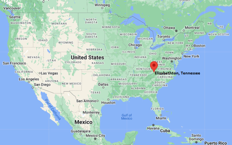
Elizabethton Map, Tennessee, USA
Where is Elizabethton?: The Google Map showing the location of Elizabethton in the U.S. state of Tennessee.
Where is Elizabethton Located?
Elizabethton is a city located in the Carter County of Tennessee, United States. Elizabethton lies between 40.1303822 Degrees North latitudes and 75.5149128 Degrees West longitudes. According to 2020 U.S.census, the population of Elizabethton city is 14546 people and the city has a total area of 9.55 sq mi. The city has numerous parks and recreational facilities.
Most Viewed US Maps
| USA Sttae Map | USA Region Map | USA Road Map |
| USA County Map | Where is USA in World Map? | US ZIP Code Map |
| USA Time Zones Map | US State and Capitals Map | USA Physical Map |
Find 4,400+ U.S. Cities by State - Explore Their Locations and Get Detailed Information
Elizabethton, Tennessee Quick Facts
| Property | Details |
|---|---|
| City | Elizabethton |
| County | Carter County |
| State | Tennessee |
| State Capital | Nashville |
| US Region | South |
| Latitude | 36.3487°N |
| Longitude | 82.2107°W |
| Elevation | 1,593 ft (486 m) |
| Land Area | 9.79 sq mi |
| Water Area | 0.09 sq mi |
| Total Area | 9.88 sq mi |
| Population (2020 Census) | 14,178 |
| Population Density | Approximately 1,448 per sq mi |
| ZIP Codes | 37643, 37644 |
| Area Code | 423 |
| Time Zone Standard | Eastern Standard Time (EST), UTC−5 |
| Time Zone Daylight | Eastern Daylight Time (EDT), UTC−4 |
| Currency | US Dollar (USD) |
| FIPS Code | 47-23500 |
| Congressional District | Tennessee's 1st Congressional District |
Nearby Cities to Elizabethton, Tennessee
- Johnson City, Tennessee - West - 10 mi
- Jonesborough, Tennessee - Southwest - 18 mi
- Erwin, Tennessee - South - 23 mi
- Bristol, Tennessee - Northeast - 25 mi
- Piney Flats, Tennessee - West - 18 mi
- Mountain City, Tennessee - Northeast - 31 mi
- Kingsport, Tennessee - Northwest - 31 mi
- Boone, North Carolina - East - 39 mi
- Greeneville, Tennessee - Southwest - 43 mi
- Asheville, North Carolina - South - 68 mi
Elizabethton, Tennessee Climate and Weather Overview
| Month | Avg High (°F) | Avg Low (°F) | Avg Rainfall (in) |
|---|---|---|---|
| January | 45 | 26 | 3.50 |
| April | 67 | 43 | 3.80 |
| July | 84 | 63 | 4.30 |
| October | 69 | 45 | 2.80 |
| Annual | 66 | 44 | 45.30 |
| Climate Attribute | Details |
|---|---|
| Climate Classification (Köppen) | Humid Subtropical (Cfa) |
| Annual Rainfall | Approximately 45 inches |
| Annual Sunshine Days | About 205 days |
| Hurricane/Tornado Risk | Very low hurricane risk; low tornado risk |
| Snowfall | Approximately 10 inches annually |
Driving Distances from Elizabethton, Tennessee
| City | State | Distance (mi) | Approx. Drive Time |
|---|---|---|---|
| Johnson City | Tennessee | 10 | 15 min |
| Piney Flats | Tennessee | 18 | 22 min |
| Jonesborough | Tennessee | 18 | 25 min |
| Erwin | Tennessee | 23 | 30 min |
| Bristol | Tennessee | 25 | 30 min |
| Mountain City | Tennessee | 31 | 40 min |
| Kingsport | Tennessee | 31 | 40 min |
| Boone | North Carolina | 39 | 55 min |
| Greeneville | Tennessee | 43 | 55 min |
| Knoxville | Tennessee | 113 | 1 hr 50 min |
Transportation and Connectivity in Elizabethton, Tennessee
| Transportation | Details |
|---|---|
| Airport Name | Tri-Cities Airport |
| IATA Code | TRI |
| Port | None |
| Major Highways | U.S. Highway 19E, U.S. Highway 321, Tennessee State Route 91, Tennessee State Route 67 |
| Train/Amtrak Service | No passenger rail service; nearest Amtrak station is in Charlotte, North Carolina |
| Local Bus/Transit Service | Johnson City Transit (regional connections) and NET Trans |
- U.S. Highway 19E connects Elizabethton with Johnson City and western North Carolina.
- U.S. Highway 321 provides access to Bristol, Lenoir, and other communities in northeast Tennessee.
- Tennessee State Routes 67 and 91 serve surrounding mountain communities and recreational areas.
- Tri-Cities Airport, about 25 miles northwest, offers regular commercial flights to major U.S. hubs.
Places to Visit in Elizabethton, Tennessee
| Landmark Name | Type |
|---|---|
| Sycamore Shoals State Historic Park | State Historic Park |
| Covered Bridge Park | City Park |
| Elizabethton Covered Bridge | Historic Bridge |
| Tweetsie Trail | Rail Trail |
| Carter Mansion | Historic House Museum |
| Watauga River | Outdoor Recreation Area |
| Doe River Gorge | Scenic Attraction |
| Roan Mountain State Park | State Park |
| Rocky Mount State Historic Site | Historic Site |
| Winged Deer Park | Regional Park |
Colleges and Universities in Elizabethton, Tennessee
| Institution Name | Type | Level | Notable For |
|---|---|---|---|
| Northeast State Community College (Elizabethton Campus) | Public | Community College | Career and technical education |
| East Tennessee State University | Public | University | Research, health sciences, and business programs |
| Milligan University | Private | University | Liberal arts and Christian education |
| King University | Private | University | Liberal arts and professional studies |
| Tusculum University | Private | University | Undergraduate and graduate programs |
| Virginia Highlands Community College | Public | Community College | Transfer and workforce training |
| Northeast State Community College | Public | Community College | Academic transfer programs |
| Elizabethton City Schools | Public | K–12 District | Public education |
Waterbodies in Elizabethton, Tennessee
Watauga River, Doe River, Watauga Lake, Boone Lake, South Holston Lake, Buffalo Creek, Stoney Creek, Little Doe River
Golf Courses in Elizabethton, Tennessee
Elizabethton Golf Course, Pine Oaks Golf Course, Johnson City Country Club, Cattails at MeadowView, Clear Creek Golf Club, Graysburg Hills Golf Course, Bristol Country Club, Tri-Cities Golf Club
Elizabethton, Tennessee — Key Historical Facts
- Elizabethton was founded in 1799 and named after Elizabeth Maclin Carter, the wife of prominent frontier settler John Carter.
- The city became the county seat of Carter County and played an important role in the early settlement of northeastern Tennessee.
- Sycamore Shoals, located in present-day Elizabethton, was the site of the historic Watauga Association and the gathering point for the Overmountain Men before the Battle of Kings Mountain in 1780.
- The arrival of the railroad and textile manufacturing in the late 19th and early 20th centuries contributed significantly to the city's economic development.
- The historic Elizabethton Covered Bridge, completed in 1882, remains one of the city's best-known landmarks and is listed on the National Register of Historic Places.
- Today, Elizabethton is known for its rich frontier history, scenic mountain surroundings, outdoor recreation, and vibrant downtown district.
References
- City of Elizabethton
- Sycamore Shoals State Historic Park
- U.S. Census Bureau
- Johnson City Convention & Visitors Bureau
Tennessee Maps & Info
- Where is Athens
- Where is Bartlett
- Where is Brentwood
- Where is Bristol
- Where is Chattanooga
- Where is Clarksville
- Where is Collierville
- Where is Columbia
- Where is Cookeville
- Where is Crossville
- Where is Dickson
- Where is Dyersburg
- Where is East Ridge
- Where is Elizabethton
- Where is Farragut
- Where is Franklin
- Where is Gallatin
- Where is Germantown
- Where is Goodlettsville
- Where is Greeneville
- Where is Hartsville
- Where is Hendersonville
- Where is Jackson
- Where is Johnson City
- Where is Kingsport
- Where is Knoxville
- Where is La Vergne
- Where is Lakeland
- Where is Lebanon
- Where is Lewisburg
- Where is Manchester
- Where is Maryville
- Where is McMinnville
- Where is Morristown
- Where is Mount Juliet
- Where is Murfreesboro
- Where is Nolensville
- Where is Oak Ridge
- Where is Sevierville
- Where is Seymour
- Where is Shelbyville
- Where is Smyrna
- Where is Soddy-Daisy
- Where is Spring Hill
- Where is Tullahoma
- Where is White House