
Where is Smyrna Located? - Smyrna is a city located in the Rutherford County of Tennessee, United States. Smyrna lies between 40.1551096 Degrees North latitudes and 74.8287747 Degrees West longitudes.
Location Map of Smyrna, Tennessee
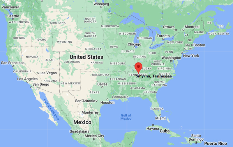
Smyrna Map, Tennessee, USA
Where is Smyrna?: The Google Map showing the location of Smyrna in the U.S. state of Tennessee.
Where is Smyrna Located?
Smyrna is a city located in the Rutherford County of Tennessee, United States. Smyrna lies between 40.1551096 Degrees North latitudes and 74.8287747 Degrees West longitudes. According to 2020 U.S.census, the population of Smyrna city is 53070 people and the city has a total area of 30.31 sq mi. The city has numerous parks and recreational facilities.
Most Viewed US Maps
| USA Sttae Map | USA Region Map | USA Road Map |
| USA County Map | Where is USA in World Map? | US ZIP Code Map |
| USA Time Zones Map | US State and Capitals Map | USA Physical Map |
Find 4,400+ U.S. Cities by State - Explore Their Locations and Get Detailed Information
Smyrna, Tennessee Quick Facts
| Attribute | Details |
|---|---|
| City | Smyrna |
| County | Rutherford County and Wilson County |
| State | Tennessee |
| State Capital | Nashville |
| US Region | Southern United States |
| Latitude | 35.9828° N |
| Longitude | 86.5186° W |
| Elevation | 522 ft (159 m) |
| Land Area (sq mi) | 25.56 |
| Water Area (sq mi) | 0.00 |
| Total Area (sq mi) | 25.56 |
| Population (2020 Census) | 53,070 |
| Population Density (per sq mi) | 2,076.2 |
| ZIP Codes | 37167 |
| Area Code | 615 |
| Time Zone Standard | Central Standard Time (CST), UTC−6 |
| Time Zone Daylight | Central Daylight Time (CDT), UTC−5 |
| Currency | United States Dollar (USD) |
| FIPS Code | 4770260 |
| Congressional District | 5th Congressional District |
Transportation and Connectivity in Smyrna
| Transportation Feature | Details |
|---|---|
| Airport Name | Nashville International Airport provides major commercial air service. |
| IATA Code | BNA |
| Port | Inland location; Nashville and Tennessee River ports provide regional access. |
| Major Highways | Interstate 24, U.S. Highway 70, and Tennessee State Route 266 |
| Train/Amtrak Service | Amtrak service is available from Nashville Station. |
| Local Bus/Transit Service | Regional transit connections are available through nearby Nashville area services. |
- Interstate 24 connects Smyrna with Nashville, Murfreesboro, and Chattanooga.
- U.S. Highway 70 provides regional connections through Middle Tennessee.
- The city is part of the Nashville metropolitan area transportation network.
- Nashville International Airport provides convenient regional and national air connections.
Top Places to Visit in Smyrna, Tennessee
| Landmark Name | Type |
|---|---|
| Smyrna Depot and Railroad Museum | Historic Museum |
| Smyrna Outdoor Adventure Center | Recreation Facility |
| Sharp Springs Natural Area | Nature Area |
| Lee Victory Recreation Park | Community Park |
| Sam Davis Home and Museum | Historic Site |
| Long Hunter State Park | State Park |
| Stones River National Battlefield | Historic Battlefield |
| Stewart Creek Greenway | Recreation Trail |
| Nashville Superspeedway | Sports Venue |
| Percy Priest Lake | Recreation Area |
Driving Distances from Smyrna, Tennessee to Nearby Cities
| City | State | Distance (mi) | Approx. Drive Time |
|---|---|---|---|
| Nashville | Tennessee | 25 | 35 min |
| Murfreesboro | Tennessee | 15 | 25 min |
| Franklin | Tennessee | 35 | 45 min |
| Lebanon | Tennessee | 30 | 40 min |
| Columbia | Tennessee | 70 | 1 hr 15 min |
| Clarksville | Tennessee | 80 | 1 hr 20 min |
| Chattanooga | Tennessee | 120 | 1 hr 50 min |
| Knoxville | Tennessee | 180 | 2 hr 45 min |
| Memphis | Tennessee | 210 | 3 hr 15 min |
| Louisville | Kentucky | 210 | 3 hr 15 min |
Colleges and Universities near Smyrna, Tennessee
| Institution Name | Type | Level | Notable For |
|---|---|---|---|
| Murfreesboro Campus - Middle Tennessee State University | Public | University | Aerospace, business, education, liberal arts, and research programs |
| Nashville State Community College | Public | Community College | Technical education, workforce training, and associate degrees |
| Tennessee State University | Public | University | Agriculture, business, education, and research programs |
| Vanderbilt University | Private | University | Medicine, law, research, and academic programs |
Waterbodies in Smyrna, Tennessee
Percy Priest Lake, Stewart Creek, Stones River, and nearby Middle Tennessee waterways
Golf Courses near Smyrna, Tennessee
Riverview Golf Course, Smyrna Golf Course, Cedar Crest Golf Club, and nearby Rutherford County golf facilities
Key Landmarks and Places to Visit in Smyrna, Tennessee
| Landmark Name | Type |
|---|---|
| Smyrna Depot and Railroad Museum | Historic Museum |
| Smyrna Outdoor Adventure Center | Recreation Facility |
| Sharp Springs Natural Area | Nature Area |
| Lee Victory Recreation Park | Community Park |
| Sam Davis Home and Museum | Historic Site |
| Long Hunter State Park | State Park |
| Stones River National Battlefield | Historic Battlefield |
| Stewart Creek Greenway | Recreation Trail |
| Nashville Superspeedway | Sports Venue |
| Percy Priest Lake | Recreation Area |
Waterbodies in Smyrna, Tennessee
Percy Priest Lake, Stewart Creek, Stones River, and nearby Middle Tennessee waterways
Golf Courses near Smyrna, Tennessee
Riverview Golf Course, Smyrna Golf Course, Cedar Crest Golf Club, and nearby Rutherford County golf facilities
Smyrna, Tennessee — Key Historical Facts
- Smyrna was settled in the early 19th century and developed as an agricultural community in Middle Tennessee.
- The town was incorporated in 1855 and grew around farming, transportation, and local trade.
- The arrival of the railroad helped Smyrna become an important regional transportation center.
- During World War II, the area became associated with military aviation activities at nearby Sewart Air Force Base.
- Smyrna experienced major growth during the late 20th and early 21st centuries as part of the Nashville metropolitan region.
References
- Town of Smyrna Official Website
- Rutherford County Government
- Wilson County Government
- U.S. Census Bureau
- Tennessee Tourism
- Middle Tennessee State University
Tennessee Maps & Info
- Where is Athens
- Where is Bartlett
- Where is Brentwood
- Where is Bristol
- Where is Chattanooga
- Where is Clarksville
- Where is Collierville
- Where is Columbia
- Where is Cookeville
- Where is Crossville
- Where is Dickson
- Where is Dyersburg
- Where is East Ridge
- Where is Elizabethton
- Where is Farragut
- Where is Franklin
- Where is Gallatin
- Where is Germantown
- Where is Goodlettsville
- Where is Greeneville
- Where is Hartsville
- Where is Hendersonville
- Where is Jackson
- Where is Johnson City
- Where is Kingsport
- Where is Knoxville
- Where is La Vergne
- Where is Lakeland
- Where is Lebanon
- Where is Lewisburg
- Where is Manchester
- Where is Maryville
- Where is McMinnville
- Where is Morristown
- Where is Mount Juliet
- Where is Murfreesboro
- Where is Nolensville
- Where is Oak Ridge
- Where is Sevierville
- Where is Seymour
- Where is Shelbyville
- Where is Smyrna
- Where is Soddy-Daisy
- Where is Spring Hill
- Where is Tullahoma
- Where is White House