Map of Keweenaw County - Keweenaw County is a county located in the U.S. state of Michigan. Keweenaw County Map showing cities, highways, important places and water bodies. Get Where is Keweenaw County located in the map, major cities in Keweenaw county, population, areas, and places of interest.
Map of Keweenaw County, Michigan
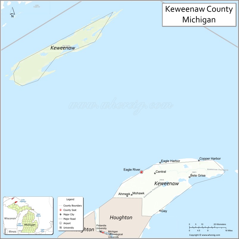
About Keweenaw County Map, Michigan: The map showing the county boundary, county seat, major cities, highways, water bodies and neighbouring counties.
Other Michigan Maps & Info
Map of Keweenaw County, Michigan
Keweenaw County is a county located in the U.S. state of Michigan. It's county seat is Eagle River. As per 2020 census, the population of Keweenaw County is 2107 people and population density is square miles. According to the United States Census Bureau, the county has a total area of 5,966 sq mi (15,452 km2). Keweenaw County was established on 1861.
Keweenaw County Facts
| County Info | Facts |
|---|---|
| County | Keweenaw County |
| County Seat | Eagle River |
| State | Michigan |
| Country | United States |
| FIPS code | 83 |
| Established | 1861 |
| Area | 5,966 sq mi (15,452 km2) |
| Population | 2107 |
| Density | |
| Formed / Origin | From part of Houghton County. |
Ctities in Keweenaw county
| City Name | Type | Population (2020) | Pop. Density | Area |
|---|---|---|---|---|
| Ahmeek | Village | 146 | 2,085.7/sq mi (805.3/km2) | 0.07 sq mi (0.18 km2) |
| Allouez | Township | 1,571 | 28.8/sq mi (11.1/km2) | 54.62 sq mi (141.5 km2) |
| Eagle Harbor | Township | 217 | 1.2/sq mi (0.5/km2) | 180.41 sq mi (467.3 km2) |
| Grant | Township | 219 | 1.8/sq mi (0.7/km2) | 119.2 sq mi (309 km2) |
| Houghton | Township | 82 | 0.7/sq mi (0.3/km2) | 120.72 sq mi (312.7 km2) |
| Sherman | Township | 67 | 1.0/sq mi (0.4/km2) | 65.16 sq mi (168.8 km2) |
- Alcona County Map
- Alger County Map
- Allegan County Map
- Alpena County Map
- Antrim County Map
- Arenac County Map
- Baraga County Map
- Barry County Map
- Bay County Map
- Benzie County Map
- Berrien County Map
- Branch County Map
- Calhoun County Map
- Cass County Map
- Charlevoix County Map
- Cheboygan County Map
- Chippewa County Map
- Clare County Map
- Clinton County Map
- Crawford County Map
- Delta County Map
- Dickinson County Map
- Eaton County Map
- Emmet County Map
- Genesee County Map
- Gladwin County Map
- Gogebic County Map
- Grand Traverse County Map
- Gratiot County Map
- Hillsdale County Map
- Houghton County Map
- Huron County Map
- Ingham County Map
- Ionia County Map
- Iosco County Map
- Iron County Map
- Isabella County Map
- Jackson County Map
- Kalamazoo County Map
- Kalkaska County Map
- Kent County Map
- Keweenaw County Map
- Lake County Map
- Lapeer County Map
- Leelanau County Map
- Lenawee County Map
- Livingston County Map
- Luce County Map
- Mackinac County Map
- Macomb County Map
- Manistee County Map
- Marquette County Map
- Mason County Map
- Mecosta County Map
- Menominee County Map
- Midland County Map
- Missaukee County Map
- Monroe County Map
- Montcalm County Map
- Montmorency County Map
- Muskegon County Map
- Newaygo County Map
- Oakland County Map
- Oceana County Map
- Ogemaw County Map
- Ontonagon County Map
- Osceola County Map
- Oscoda County Map
- Otsego County Map
- Ottawa County Map
- Presque Isle County Map
- Roscommon County Map
- Saginaw County Map
- St Clair County Map
- St Joseph County Map
- Sanilac County Map
- Schoolcraft County Map
- Shiawassee County Map
- Tuscola County Map
- Van Buren County Map
- Washtenaw County Map
- Wayne County Map
- Wexford County Map
- Alabama Counties
- Alaska boroughs
- Arizona Counties
- Arkansas Counties
- California County Map
- Colorado Counties
- Connecticut Counties
- Delaware Counties
- Florida County Map
- Georgia County Map
- Hawaii Counties
- Idaho Counties
- Illinois Counties
- Indiana Counties
- Iowa Counties
- Kansas Counties
- Kentucky Counties
- Louisiana Counties
- Maine Counties
- Maryland Counties
- Massachusetts Counties
- Michigan County Map
- Minnesota Counties
- Mississippi Counties
- Missouri Counties
- Montana Counties
- Nebraska Counties
- Nevada Counties
- New York Counties
- New Hampshire Counties
- New Jersey Counties
- New Mexico Counties
- North Carolina Counties
- North Dakota Counties
- Ohio County Map
- Oklahoma Counties
- Oregon Counties
- Pennsylvania Counties
- Rhode Island Counties
- South Carolina Counties
- South Dakota Counties
- Map of Tennessee
- Texas County Map
- Utah Counties
- Vermont Counties
- Virginia Counties
- Washington Counties
- West Virginia Counties
- Wisconsin Counties
- Wyoming Counties