
Dixon is a city in Solano County in Northern California's Sacramento Valley. It sits between Sacramento and the San Francisco Bay Area, about 23 miles southwest of Sacramento. Known for its agricultural setting and strong farming heritage, Dixon is surrounded by fields and orchards and is also close to destinations such as the Jelly Belly visitor center in Fairfield and the Suisun Valley.
Location Map of Dixon, Solano County, California
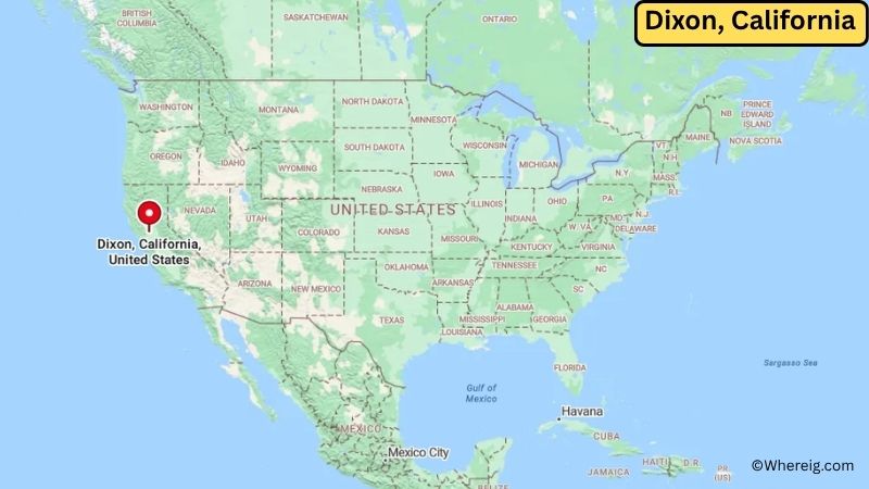
About Map: The map shows the location of Dixon in Solano County, in the U.S. state of California.
Dixon Map, California
About Dixon Map: The Google Map highlights the location of Dixon in Solano County, California. Use the zoom, satellite, and street-view options to explore the city's neighborhoods, roads, and nearby places.
Where is Dixon Located?
Dixon is a city located in Solano County, California, the United States. It is located in the Sacramento Valley, about 23 miles southwest of Sacramento and approximately 65 miles northeast of San Francisco. The city lies at about 38.45° North latitude and 121.82° West longitude. The 2020 Census recorded 18,960 residents. Dixon covers approximately 7.43 square miles (19.25 square kilometers), with nearly all of its area consisting of land. Agriculture has played a major role in the city's development, with the surrounding region known for tomatoes, almonds, walnuts, and other crops. Dixon was incorporated in 1878 and grew around the railroad and farming industries. The city is known for the Dixon May Fair, one of California's oldest fairs. Nearby attractions include the University of California, Davis, the Jelly Belly Visitor Center, and the Suisun Valley. Dixon's location along Interstate 80 makes it an important connection between Sacramento and the Bay Area.
Most Viewed US Maps
| USA Sttae Map | USA Region Map | USA Road Map |
| USA County Map | Where is USA in World Map? | US ZIP Code Map |
| USA Time Zones Map | US State and Capitals Map | USA Physical Map |
Find 4,400+ U.S. Cities by State - Explore Their Locations and Get Detailed Information
Dixon City Facts
| City | Dixon |
| State | California |
| County | Solano County |
| Country | United States |
| Region | Sacramento Valley |
| Incorporated | April 30, 1878 |
| Founded | 1852 |
| Total Area | 7.43 sq mi (19.25 sq km) |
| Land Area | 7.41 sq mi (19.19 sq km) |
| Water Area | 0.02 sq mi (0.05 sq km) |
| Elevation | 52 ft (16 m) |
| Population (2023 estimate) | Approximately 19,500 |
| Population (2020 Census) | 18,960 |
| Population Density | 2,556 people per sq mi |
| Time Zone | Pacific Time Zone (PST/PDT) |
| ZIP Codes | 95620 |
| Area Code | 707, 369 |
| Major Highways | Interstate 80, California State Route 113 |
| Public Transit | Dixon Readi-Ride |
| Major Attractions | Dixon May Fair, Hall Memorial Park, Northwest Park, Jelly Belly Visitor Center |
| Official Website | https://www.cityofdixon.us/ |
Distance from Dixon, CA to Nearby Cities
- Davis, CA – 10 miles (16 km)
- Vacaville, CA – 11 miles (18 km)
- Winters, CA – 12 miles (19 km)
- Woodland, CA – 15 miles (24 km)
- Fairfield, CA – 16 miles (26 km)
- West Sacramento, CA – 22 miles (35 km)
- Sacramento, CA – 23 miles (37 km)
- Vallejo, CA – 31 miles (50 km)
- Napa, CA – 34 miles (55 km)
- Rio Vista, CA – 27 miles (43 km)
- Benicia, CA – 35 miles (56 km)
- Antioch, CA – 42 miles (68 km)
- Stockton, CA – 48 miles (77 km)
- Santa Rosa, CA – 61 miles (98 km)
- San Francisco, CA – 65 miles (105 km)
- Oakland, CA – 63 miles (101 km)
- Modesto, CA – 72 miles (116 km)
- Lake Tahoe, CA – 110 miles (177 km)
Top Attractions in Dixon
- Dixon May Fair – A long-running annual community fair celebrating agriculture, livestock, food, and local entertainment.
- Dixon Historical Museum – A local museum preserving artifacts and stories from Dixon's agricultural and railroad history.
- Hall Memorial Park – A community park with recreational facilities and open areas for outdoor activities.
- Northwest Park – A neighborhood park offering walking areas, playgrounds, and recreational space.
- Dixon Fruit and Produce Stands – Seasonal roadside stands and farms reflect the city's agricultural character.
- Jelly Belly Visitor Center – A popular attraction in nearby Fairfield featuring tours, exhibits, and information about the Jelly Belly brand.
- UC Davis Arboretum – A scenic outdoor destination at the University of California, Davis, with gardens and walking paths.
- Putah Creek – A nearby natural waterway offering opportunities for walking, wildlife viewing, and outdoor recreation.
Airports Near Dixon
- Sacramento International Airport (SMF) – 25 miles
- Buchanan Field Airport (CCR) – 45 miles
- Oakland International Airport (OAK) – 65 miles
- San Francisco International Airport (SFO) – 75 miles
Sources:
Population and area data sourced from the United States Census Bureau (2020 Census). General city information referenced from the official City of Dixon website and local government records.
California Related Links
- Where is Los Angeles
- Where is San Diego
- Where is San Francisco
- Where is Anaheim
- Where is Bakersfield
- Where is Chula Vista
- Where is Freemont
- Where is Fresno
- Where is Glendale
- Where is Irvine
- Where is Long Beach
- Where is Modesto
- Where is Oakland
- Where is Paradise
- Where is Riverside
- Where is Sacramento
- Where is San Bernardino
- Where is San Jose
- Where is Santa Ana
- Where is Stockton
- Where is Berkeley
- Where is Clovis
- Where is Corona
- Where is Elk Grove
- Where is Escondido
- Where is Fontana
- Where is Fremont
- Where is Fullerton
- Where is Garden Grove
- Where is Hayward
- Where is Huntington Beach
- Where is Lancaster
- Where is Moreno Valley
- Where is Oceanside
- Where is Ontario
- Where is Orange
- Where is Oxnard
- Where is Palmdale
- Where is Pasadena
- Where is Pomona
- Where is Rancho Cucamonga
- Where is Roseville
- Where is Salinas
- Where is Santa Clara
- Where is Santa Clarita
- Where is Santa Rosa
- Where is Sunnyvale
- Where is Thousand Oaks
- Where is Torrance
- Where is Vallejo
- Where is Victorville
- Where is Visalia