
Fortuna is a city in Northern California's Redwood Coast region and part of Humboldt County. It is about 25 miles south of Eureka and lies in the Eel River Valley. The city is known for its redwood forests, nearby Victorian Ferndale, Riverwalk, and easy access to Humboldt Redwoods State Park and the scenic Pacific coastline.
Location Map of Fortuna, Humboldt County, California
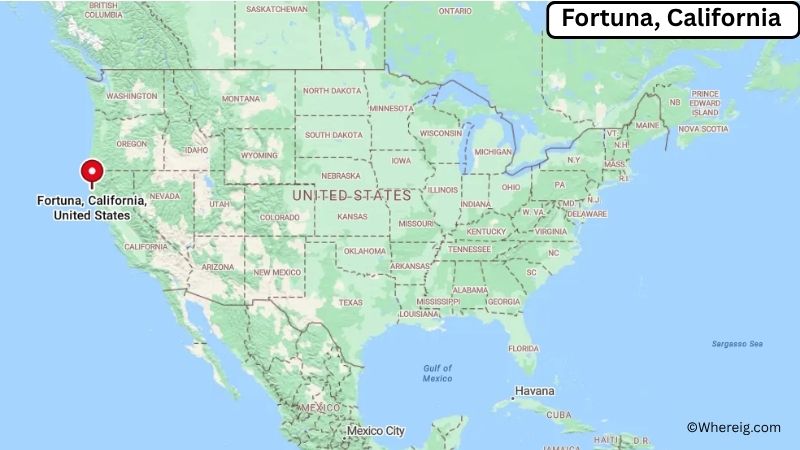
About Map: The map shows the location of Fortuna in Humboldt County, in the U.S. state of California.
Fortuna Map, California
About Fortuna Map: The Google Map highlights the location of Fortuna in Humboldt County, California. Use the zoom, satellite, and street-view options to explore the city's neighborhoods, roads, and nearby places.
Where is Fortuna Located?
Fortuna is a city located in Humboldt County, California, the United States. It lies in the Eel River Valley along California's North Coast, about 25 miles south of Eureka, 10 miles east of the Pacific Ocean, and roughly 30 miles north of Scotia. Fortuna is positioned at approximately 40.598° North latitude and 124.157° West longitude. The city covers about 4.85 square miles, or 12.56 square kilometers, of land. The 2020 Census recorded 11,926 residents, while recent estimates place the population at about 12,000. Fortuna stands at an elevation of roughly 60 feet above sea level. The city grew from a late 19th-century settlement connected to logging, agriculture, dairy farming, and transportation in the Eel River Valley. Redwood forests remain an important part of the surrounding landscape. The Eel River runs near the city and provides a major geographic feature of the area. Fortuna is also known for its proximity to the Victorian town of Ferndale and the giant redwoods of Humboldt Redwoods State Park. U.S. Route 101 runs directly through Fortuna, making the city an important stop along California's Redwood Coast.
Most Viewed US Maps
| USA Sttae Map | USA Region Map | USA Road Map |
| USA County Map | Where is USA in World Map? | US ZIP Code Map |
| USA Time Zones Map | US State and Capitals Map | USA Physical Map |
Find 4,400+ U.S. Cities by State - Explore Their Locations and Get Detailed Information
Fortuna City Facts
| City | Fortuna |
|---|---|
| State | California |
| County | Humboldt County |
| Country | United States |
| Region | North Coast, Redwood Coast, Eel River Valley |
| Incorporated | February 20, 1906 |
| Founded | 1870s |
| Total Area | 4.85 sq mi (12.56 sq km) |
| Land Area | 4.85 sq mi (12.56 sq km) |
| Water Area | 0 sq mi (0 sq km) |
| Elevation | 60 ft (18 m) |
| Population (2023 estimate) | About 12,000 |
| Population (2020 Census) | 11,926 |
| Population Density | 2,459.0 people per sq mi |
| Time Zone | Pacific Time (PST/PDT) |
| ZIP Codes | 95540 |
| Area Code | 707 |
| Major Highways | U.S. Route 101, California State Route 36 |
| Public Transit | Redwood Transit System |
| Major Attractions | Fortuna Riverwalk, Rohner Park, Redwood National and State Parks, Humboldt Redwoods State Park, Ferndale |
| Official Website | https://www.friendlyfortuna.com/ |
Distance from Fortuna, CA to Nearby Cities
- Ferndale, CA – 10 miles (16 km)
- Rio Dell, CA – 10 miles (16 km)
- Scotia, CA – 12 miles (19 km)
- Eureka, CA – 25 miles (40 km)
- Arcata, CA – 30 miles (48 km)
- McKinleyville, CA – 35 miles (56 km)
- Garberville, CA – 55 miles (89 km)
- Redway, CA – 50 miles (80 km)
- Trinidad, CA – 50 miles (80 km)
- Willow Creek, CA – 55 miles (89 km)
- Fort Bragg, CA – 135 miles (217 km)
- Ukiah, CA – 145 miles (233 km)
- Redding, CA – 150 miles (241 km)
- Santa Rosa, CA – 185 miles (298 km)
- Chico, CA – 190 miles (306 km)
- Medford, OR – 190 miles (306 km)
- Sacramento, CA – 250 miles (402 km)
- San Francisco, CA – 265 miles (426 km)
Top Attractions in Fortuna
- Fortuna Riverwalk – A scenic walking and recreation area along the Eel River with trails, open space, wildlife viewing, and river views.
- Rohner Park – A large community park with picnic areas, sports facilities, playgrounds, walking paths, and spaces for local events.
- Humboldt Redwoods State Park – A major redwood forest park south of Fortuna featuring the Avenue of the Giants, hiking trails, campgrounds, and giant coastal redwoods.
- Ferndale Historic District – A nearby Victorian-era town known for beautifully preserved buildings, historic streets, local shops, and restaurants.
- Fortuna Depot Museum – A local museum preserving railroad and regional history connected to Fortuna and the Eel River Valley.
- Humboldt Botanical Gardens – A botanical garden near Eureka featuring native plants, gardens, trails, and views of the surrounding landscape.
- Redwood National and State Parks – A nationally protected landscape farther north containing some of the world's tallest trees, coastal forests, beaches, and hiking trails.
- Headwaters Forest Reserve – A protected redwood forest area east of Fortuna with old-growth trees and important wildlife habitat.
- Table Bluff County Park – A coastal recreation area west of Fortuna offering ocean views and access to the rugged North Coast landscape.
- Lost Coast – A remote section of Northern California coastline known for rugged beaches, cliffs, wilderness, and hiking opportunities.
Airports Near Fortuna
- California Redwood Coast-Humboldt County Airport (ACV) – 40 miles
- Rohnerville Airport (FOT) – 5 miles
- Garberville Airport (O16) – 55 miles
- Little River Airport (LLR) – 145 miles
- Arcata-Eureka Airport (ACV) – 40 miles
Sources:
Population and area data sourced from the United States Census Bureau (2020 Census). General city information referenced from the official City of Fortuna website and local government records.
California Related Links
- Where is Los Angeles
- Where is San Diego
- Where is San Francisco
- Where is Anaheim
- Where is Bakersfield
- Where is Chula Vista
- Where is Freemont
- Where is Fresno
- Where is Glendale
- Where is Irvine
- Where is Long Beach
- Where is Modesto
- Where is Oakland
- Where is Paradise
- Where is Riverside
- Where is Sacramento
- Where is San Bernardino
- Where is San Jose
- Where is Santa Ana
- Where is Stockton
- Where is Berkeley
- Where is Clovis
- Where is Corona
- Where is Elk Grove
- Where is Escondido
- Where is Fontana
- Where is Fremont
- Where is Fullerton
- Where is Garden Grove
- Where is Hayward
- Where is Huntington Beach
- Where is Lancaster
- Where is Moreno Valley
- Where is Oceanside
- Where is Ontario
- Where is Orange
- Where is Oxnard
- Where is Palmdale
- Where is Pasadena
- Where is Pomona
- Where is Rancho Cucamonga
- Where is Roseville
- Where is Salinas
- Where is Santa Clara
- Where is Santa Clarita
- Where is Santa Rosa
- Where is Sunnyvale
- Where is Thousand Oaks
- Where is Torrance
- Where is Vallejo
- Where is Victorville
- Where is Visalia