
Where is Senatobia Located? - Senatobia is a city located in the Tate County of Mississippi, United States. Senatobia lies between 39.0479645 Degrees North latitudes and 119.7221216 Degrees West longitudes.
Location Map of Senatobia, Mississippi
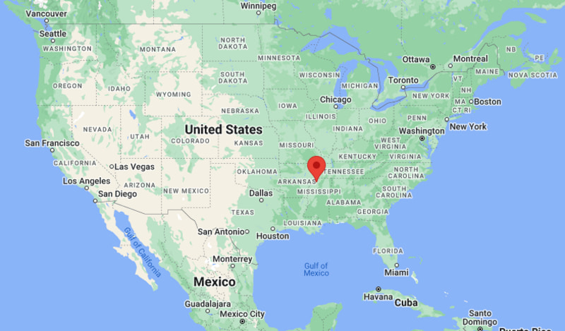
Senatobia Map, Mississippi, USA
Where is Senatobia?: The Google Map showing the location of Senatobia in the U.S. state of Mississippi.
Where is Senatobia Located?
Senatobia is a city located in the Tate County of Mississippi, United States. Senatobia lies between 39.0479645 Degrees North latitudes and 119.7221216 Degrees West longitudes. According to 2020 U.S.census, the population of Senatobia city is 8354 people and the city has a total area of 15.56 sq mi. The city has numerous parks and recreational facilities.
Most Viewed US Maps
| USA Sttae Map | USA Region Map | USA Road Map |
| USA County Map | Where is USA in World Map? | US ZIP Code Map |
| USA Time Zones Map | US State and Capitals Map | USA Physical Map |
Find 4,400+ U.S. Cities by State - Explore Their Locations and Get Detailed Information
Senatobia, Mississippi Quick Facts
| Attribute | Details |
|---|---|
| City | Senatobia |
| County | Tate County |
| State | Mississippi |
| State Capital | Jackson |
| US Region | Southern United States |
| Latitude | 34.6176° N |
| Longitude | 89.9676° W |
| Elevation | 400 ft (122 m) |
| Land Area (sq mi) | 15.41 |
| Water Area (sq mi) | 0.10 |
| Total Area (sq mi) | 15.51 |
| Population (2020 Census) | 7,371 |
| Population Density (per sq mi) | 478.3 |
| ZIP Codes | 38668 |
| Area Code | 662 |
| Time Zone Standard | Central Standard Time (CST), UTC−6 |
| Time Zone Daylight | Central Daylight Time (CDT), UTC−5 |
| Currency | United States Dollar (USD) |
| FIPS Code | 2866000 |
| Congressional District | 1st Congressional District |
Transportation and Connectivity in Senatobia
| Transportation Feature | Details |
|---|---|
| Airport Name | Northwest Mississippi Regional Airport; Memphis International Airport is the nearest major commercial airport. |
| IATA Code | TPA; MEM for Memphis International Airport |
| Port | None |
| Major Highways | Interstate 55, U.S. Highway 51, Mississippi Highway 4, and Mississippi Highway 6 |
| Train/Amtrak Service | No Amtrak passenger station is located in Senatobia. Amtrak service is available in nearby Marks and Memphis. |
| Local Bus/Transit Service | Local public transportation options are limited; regional transportation services operate in Tate County. |
- Interstate 55 runs north-south along the western side of Senatobia and connects the city with Memphis, Jackson, and other communities along the Mississippi River corridor.
- U.S. Highway 51 runs north-south through Senatobia and provides a local connection toward Hernando, Batesville, and Memphis.
- Mississippi Highway 4 provides an east-west connection through the Senatobia area and links the city with communities in northern Mississippi.
- Mississippi Highway 6 connects Senatobia with Batesville to the east and Oxford and other northern Mississippi communities.
Top Places to Visit in Senatobia, Mississippi
| Landmark Name | Type |
|---|---|
| Northwest Mississippi Community College | College Campus |
| Northwest Mississippi Regional Airport | Airport |
| Jim Thomas Park | Park |
| Senatobia City Park | Park |
| Tate County Courthouse | Historic Government Building |
| Downtown Senatobia | Historic Downtown |
| Hugh White State Park | State Park |
| Enid Lake | Reservoir |
| George P. Cossar State Park | State Park |
| Wall Doxey State Park | State Park |
Driving Distances from Senatobia, Mississippi to Nearby Cities
| City | State | Distance (mi) | Approx. Drive Time |
|---|---|---|---|
| Coldwater | Mississippi | 10 | 15 min |
| Batesville | Mississippi | 31 | 35 min |
| Hernando | Mississippi | 24 | 25 min |
| Oxford | Mississippi | 45 | 50 min |
| Southaven | Mississippi | 37 | 40 min |
| Olive Branch | Mississippi | 43 | 45 min |
| Memphis | Tennessee | 47 | 50 min |
| Grenada | Mississippi | 55 | 1 hr |
| Clarksdale | Mississippi | 58 | 1 hr |
| Starkville | Mississippi | 105 | 1 hr 45 min |
Colleges and Universities in Senatobia, Mississippi
| Institution Name | Type | Level | Notable For |
|---|---|---|---|
| Northwest Mississippi Community College | Public | Community College | Academic, career, and technical programs |
| University of Mississippi | Public | University | Research and higher education |
| Mississippi State University | Public | University | Research, agriculture, and engineering |
| Rust College | Private | University | Historically Black liberal arts education |
Waterbodies in Senatobia, Mississippi
Coldwater River, Enid Lake, Lake Tate, Cane Creek
Golf Courses in Senatobia, Mississippi
Senatobia Country Club, The Club at North Creek, Mallard Pointe Golf Course
Key Landmarks and Places to Visit in Senatobia, Mississippi
| Landmark Name | Type |
|---|---|
| Northwest Mississippi Community College | College Campus |
| Jim Thomas Park | Park |
| Senatobia City Park | Park |
| Tate County Courthouse | Historic Government Building |
| Downtown Senatobia | Historic Downtown |
| Enid Lake | Reservoir |
| George P. Cossar State Park | State Park |
| Wall Doxey State Park | State Park |
| Hugh White State Park | State Park |
| Coldwater River | Natural Attraction |
Waterbodies in Senatobia, Mississippi
Coldwater River, Enid Lake, Lake Tate, Cane Creek
Golf Courses in Senatobia, Mississippi
Senatobia Country Club, The Club at North Creek, Mallard Pointe Golf Course
Senatobia, Mississippi — Key Historical Facts
- Senatobia was founded in the 1850s and developed as a community along important transportation routes in northern Mississippi.
- The town was named Senatobia, a name associated with a Chickasaw word interpreted as meaning “white sycamore.”
- Senatobia became the county seat of Tate County and developed as a regional center for agriculture, commerce, and government.
- The arrival of the railroad helped Senatobia expand its connections with Memphis and other communities in northern Mississippi.
- Northwest Mississippi Community College has been an important educational institution in Senatobia since its establishment in 1928.
References
- City of Senatobia Official Website
- Tate County Government
- U.S. Census Bureau
- Visit Mississippi
- Northwest Mississippi Community College
- Mississippi State Parks
Other Mississippi Maps & Info
- Where is Aberdeen
- Where is Amory
- Where is Baldwyn
- Where is Batesville
- Where is Bay St. Louis
- Where is Biloxi
- Where is Booneville
- Where is Brandon
- Where is Brookhaven
- Where is Byram
- Where is Canton
- Where is Carthage
- Where is Clarksdale
- Where is Cleveland
- Where is Clinton
- Where is Columbia
- Where is Columbus
- Where is Corinth
- Where is Crystal Springs
- Where is D'Iberville
- Where is Diamondhead
- Where is Ellisville
- Where is Florence
- Where is Flowood
- Where is Forest
- Where is Fulton
- Where is Gautier
- Where is Greenville
- Where is Greenwood
- Where is Grenada
- Where is Gulf Hills
- Where is Gulfport
- Where is Hattiesburg
- Where is Hazlehurst
- Where is Hernando
- Where is Holly Springs
- Where is Horn Lake
- Where is Houston
- Where is Indianola
- Where is Iuka
- Where is Jackson
- Where is Kosciusko
- Where is Laurel
- Where is Leland
- Where is Long Beach
- Where is Louisville
- Where is Madison
- Where is Magee
- Where is McComb
- Where is Meridian
- Where is Morton
- Where is Moss Point
- Where is Natchez
- Where is New Albany
- Where is Newton
- Where is Ocean Springs
- Where is Olive Branch
- Where is Oxford
- Where is Pass Christian
- Where is Pascagoula
- Where is Pearl
- Where is Petal
- Where is Philadelphia
- Where is Picayune
- Where is Pontotoc
- Where is Richland
- Where is Ridgeland
- Where is Ripley
- Where is Ruleville
- Where is Saltillo
- Where is Senatobia
- Where is Southaven
- Where is St. Martin
- Where is Starkville
- Where is Tupelo
- Where is Tutwiler
- Where is Verona
- Where is Vicksburg
- Where is Water Valley
- Where is Waveland
- Where is Waynesboro
- Where is West Point
- Where is Wiggins
- Where is Winona
- Where is Yazoo City