
Where is Bay St. Louis Located? - Bay St. Louis is a city located in the Hancock County of Mississippi, United States. Bay St. Louis lies between 30.3088 Degrees North latitudes and -89.3344 Degrees West longitudes.
Location Map of Bay St. Louis, Mississippi
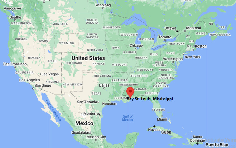
Bay St. Louis Map, Mississippi, USA
Where is Bay St. Louis?: The Google Map showing the location of Bay St. Louis in the U.S. state of Mississippi.
Where is Bay St. Louis Located?
Bay St. Louis is a city located in the Hancock County of Mississippi, United States. Bay St. Louis lies at approximately 30.3088 Degrees North latitude and -89.3344 Degrees West longitude. According to the 2020 U.S. Census, the population of Bay St. Louis city is 9,284 people and the city has a total area of 14.69 sq mi. The city has numerous parks and recreational facilities.
Most Viewed US Maps
| USA Sttae Map | USA Region Map | USA Road Map |
| USA County Map | Where is USA in World Map? | US ZIP Code Map |
| USA Time Zones Map | US State and Capitals Map | USA Physical Map |
Find 4,400+ U.S. Cities by State - Explore Their Locations and Get Detailed Information
Bay St. Louis, Mississippi Quick Facts
| Fact | Details |
|---|---|
| City | Bay St. Louis |
| County | Hancock County |
| State | Mississippi |
| Country | United States |
| Region | Mississippi Gulf Coast |
| Latitude | 30.3088 N |
| Longitude | -89.3344 W |
| Elevation | 23 ft (7 m) |
| Land Area | 13.8 sq mi |
| Water Area | 2.8 sq mi |
| Total Area | 14.69 sq mi |
| Population (Census 2020) | 9,707 |
| Population Density | Approximately 703 per sq mi |
| ZIP Code | 39520 |
| Area Code | 228 |
| Time Zone | Central Time (CT) |
| FIPS Code | 28-03940 |
Nearby Cities and Communities to Bay St. Louis, Mississippi
- Waveland, Mississippi - 3 mi (5 km)
- Diamondhead, Mississippi - 8 mi (13 km)
- Pass Christian, Mississippi - 12 mi (19 km)
- Kiln, Mississippi - 14 mi (23 km)
- Pearlington, Mississippi - 18 mi (29 km)
- Long Beach, Mississippi - 24 mi (39 km)
- Gulfport, Mississippi - 33 mi (53 km)
- Slidell, Louisiana - 35 mi (56 km)
- Biloxi, Mississippi - 47 mi (76 km)
- New Orleans, Louisiana - 59 mi (95 km)
Bay St. Louis, Mississippi Climate and Weather Overview
| Month | Avg High | Avg Low | Avg Precipitation |
|---|---|---|---|
| January | 62°F | 43°F | 5.5 in |
| April | 77°F | 57°F | 5.3 in |
| July | 91°F | 75°F | 7.3 in |
| October | 81°F | 60°F | 3.8 in |
| Climate Attribute | Details |
|---|---|
| Climate Type | Humid Subtropical (Cfa) |
| Annual Rainfall | Approximately 65 inches |
| Annual Sunshine | Approximately 220 sunny days |
| Average Snowfall | Rare |
| Main Weather Risks | Hurricanes, Tropical Storms, Coastal Flooding and Thunderstorms |
Driving Distances from Bay St. Louis, Mississippi
| Destination | Distance | Distance (km) | Drive Time |
|---|---|---|---|
| Waveland | 3 mi | 5 km | 6 min |
| Diamondhead | 8 mi | 13 km | 12 min |
| Pass Christian | 12 mi | 19 km | 18 min |
| Kiln | 14 mi | 23 km | 20 min |
| Long Beach | 24 mi | 39 km | 28 min |
| Gulfport | 33 mi | 53 km | 38 min |
| Slidell | 35 mi | 56 km | 40 min |
| Biloxi | 47 mi | 76 km | 55 min |
| New Orleans | 59 mi | 95 km | 1 hr 5 min |
Transportation and Connectivity in Bay St. Louis, Mississippi
| Nearest Airport | Gulfport-Biloxi International Airport |
| IATA Code | GPT |
| Major Airport | Louis Armstrong New Orleans International Airport (MSY) |
| Major Highways | Interstate 10, U.S. Highway 90 and Mississippi Highway 603 |
| Rail Service | Amtrak (Bay St. Louis Station) |
| Public Transit | Coast Transit Authority (CTA) |
- Bay St. Louis is the county seat of Hancock County.
- The city is known for its historic Old Town district and scenic Gulf Coast beaches.
- Tourism, boating, fishing, hospitality and healthcare are major contributors to the local economy.
- Bay St. Louis is recognized as one of Mississippi's premier coastal arts communities.
- The city offers easy access to New Orleans while maintaining a relaxed small-town atmosphere.
Key Landmarks and Places to Visit in Bay St. Louis, Mississippi
| Landmark | Type |
|---|---|
| Old Town Bay St. Louis | Historic District |
| Bay St. Louis Beach | Public Beach |
| Alice Moseley Folk Art Museum | Art Museum |
| 100 Men D.B.A. Hall | Historic Landmark |
| Hancock County Historical Society Museum | Museum |
| Washington Street Pier | Fishing Pier |
| Buccaneer State Park | State Park |
| Hollywood Casino Gulf Coast | Casino Resort |
Colleges and Universities Near Bay St. Louis, Mississippi
| Institution | Type | Distance | Notable For |
|---|---|---|---|
| Pearl River Community College | Community College | 20 mi | Career and transfer programs |
| University of Southern Mississippi - Gulf Park | Public University | 28 mi | Business and coastal studies |
| Mississippi Gulf Coast Community College | Community College | 30 mi | Technical and workforce education |
| Tulane University | Private University | 61 mi | Research and professional studies |
| University of New Orleans | Public University | 60 mi | Engineering and research |
Waterbodies in and Near Bay St. Louis, Mississippi
Bay of St. Louis, Mississippi Sound, Jourdan River, Wolf River, Gulf of Mexico, Bayou La Croix, Pearl River, Heron Bay, Hancock Bay and Jordan Bay.
Golf Courses in and Near Bay St. Louis, Mississippi
The Bridges Golf Club at Hollywood Casino, Diamondhead Country Club (Cardinal Course), Diamondhead Country Club (Pine Course), Pass Christian Isles Golf Club, Windance Country Club, Grand Bear Golf Club and Shell Landing Golf Club.
Bay St. Louis, Mississippi - Key Historical Facts
- French settlers established Bay St. Louis during the late seventeenth century, making it one of the oldest communities on the Gulf Coast.
- The city became an important fishing, shipping and resort destination during the nineteenth century.
- Its historic downtown preserves many restored homes, galleries and cultural landmarks.
- Hurricane Katrina caused extensive damage in 2005, followed by a major community rebuilding effort.
- Today, Bay St. Louis is celebrated for its waterfront, arts scene and historic coastal character.
References
- City of Bay St. Louis
- U.S. Census Bureau
- Visit Hancock County
- Mississippi Department of Transportation
Other Mississippi Maps & Info
- Where is Aberdeen
- Where is Amory
- Where is Baldwyn
- Where is Batesville
- Where is Bay St. Louis
- Where is Biloxi
- Where is Booneville
- Where is Brandon
- Where is Brookhaven
- Where is Byram
- Where is Canton
- Where is Carthage
- Where is Clarksdale
- Where is Cleveland
- Where is Clinton
- Where is Columbia
- Where is Columbus
- Where is Corinth
- Where is Crystal Springs
- Where is D'Iberville
- Where is Diamondhead
- Where is Ellisville
- Where is Florence
- Where is Flowood
- Where is Forest
- Where is Fulton
- Where is Gautier
- Where is Greenville
- Where is Greenwood
- Where is Grenada
- Where is Gulf Hills
- Where is Gulfport
- Where is Hattiesburg
- Where is Hazlehurst
- Where is Hernando
- Where is Holly Springs
- Where is Horn Lake
- Where is Houston
- Where is Indianola
- Where is Iuka
- Where is Jackson
- Where is Kosciusko
- Where is Laurel
- Where is Leland
- Where is Long Beach
- Where is Louisville
- Where is Madison
- Where is Magee
- Where is McComb
- Where is Meridian
- Where is Morton
- Where is Moss Point
- Where is Natchez
- Where is New Albany
- Where is Newton
- Where is Ocean Springs
- Where is Olive Branch
- Where is Oxford
- Where is Pass Christian
- Where is Pascagoula
- Where is Pearl
- Where is Petal
- Where is Philadelphia
- Where is Picayune
- Where is Pontotoc
- Where is Richland
- Where is Ridgeland
- Where is Ripley
- Where is Ruleville
- Where is Saltillo
- Where is Senatobia
- Where is Southaven
- Where is St. Martin
- Where is Starkville
- Where is Tupelo
- Where is Tutwiler
- Where is Verona
- Where is Vicksburg
- Where is Water Valley
- Where is Waveland
- Where is Waynesboro
- Where is West Point
- Where is Wiggins
- Where is Winona
- Where is Yazoo City