Written and Fact-checked by Whereig Editors, Reviewed by Mukesh Kumar| Last Updated On: May 12, 2026
Map of Hancock County - Hancock County is a county located in the U.S. state of Mississippi. Hancock County Map showing cities, highways, important places and water bodies. Get Where is Hancock County located in the map, major cities in Hancock county, population, areas, and places of interest.
Map of Hancock County, Mississippi
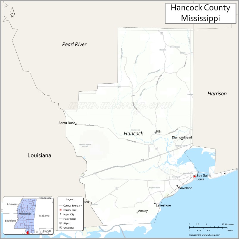
About Hancock County Map, Mississippi: The map showing the county boundary, county seat, major cities, highways, water bodies and neighbouring counties.
Other Mississippi Maps & Info
Hancock County, Mississippi
Hancock County is a county located in the U.S. state of Mississippi. It's county seat is Bay St. Louis. As per 2020 census, the population of Hancock County is 46055 people and population density is square miles. According to the United States Census Bureau, the county has a total area of 477 sq mi (1,235 km2). Hancock County was established on 1812.
Hancock County Facts
| Continent | North America |
| Country | United States |
| State | Mississippi |
| County Seat | Bay St. Louis |
| Largest City/Town | Bay St. Louis |
| Established | 1812 |
| Total Area | 553 sq mi (1,432 sq km) |
| Land Area | 474 sq mi (1,227 sq km) |
| Water Area | 79 sq mi (205 sq km) |
| Population | 48,693 (Census 2020) |
| Population Density | 102.7 people per sq mi |
| Time Zone | Central Time Zone |
| Major Highways | Interstate 10, U.S. Route 90, Mississippi Highway 43 |
| Major Rivers | Pearl River, Jourdan River |
| Neighboring Counties | Harrison County, Pearl River County, St. Tammany Parish (Louisiana) |
| Famous For | Mississippi Gulf Coast beaches, Bay St. Louis arts culture, and NASA Stennis Space Center |
| Top Attractions | Bay St. Louis Beach, Buccaneer State Park, and NASA Stennis Space Center nearby region |
| Official Website | Official Website |
About Hancock County, Mississippi
Hancock County is located on the Mississippi Gulf Coast bordering Louisiana and was established in 1812. The county seat and largest city is Bay St. Louis, a coastal community known for its beaches, art galleries, seafood restaurants, and historic charm. The county is famous for tourism, outdoor recreation, and the nearby NASA Stennis Space Center.
Cities and Towns in Hancock County, Mississippi
| City/Town | Population (Census 2020) | Latitude & Longitude |
|---|---|---|
| Bay St. Louis (county seat) | 9,677 | 30.3088°N, 89.3300°W |
| Waveland | 6,435 | 30.2869°N, 89.3767°W |
| Diamondhead | 9,529 | 30.3946°N, 89.3631°W |
| Kiln nearby region | 2,200 | 30.4116°N, 89.4387°W |
| Pearlington nearby region | 1,200 | 30.2463°N, 89.6117°W |
Golf Courses in Hancock County, Mississippi
| Golf Course | Location | Latitude & Longitude |
|---|---|---|
| Diamondhead Country Club | Diamondhead | 30.3941°N, 89.3694°W |
| The Bridges Golf Club | Bay St. Louis | 30.3232°N, 89.3617°W |
| Bayou Vista Golf Course nearby region | Waveland area | 30.2956°N, 89.3818°W |
What Are the Major Roads and Highways in Hancock County, Mississippi
Major highways connect Hancock County with the Mississippi Gulf Coast and southeastern Louisiana.
- Interstate 10 - major east-west interstate linking Gulf Coast cities
- U.S. Route 90 - scenic coastal highway running along the Gulf of Mexico
- Mississippi Highway 43 - regional north-south route connecting inland communities
Neighboring Counties and Parishes of Hancock County
- Harrison County (east)
- Pearl River County (north)
- St. Tammany Parish, Louisiana (west)
What Are the Top Attractions in Hancock County, Mississippi
The county offers Gulf Coast beaches, outdoor recreation, and arts and cultural attractions.
- Bay St. Louis Beach - scenic Gulf Coast beach area popular for relaxation, fishing, and waterfront dining
- Buccaneer State Park - coastal recreation area with camping, water park attractions, and beach access
- NASA Stennis Space Center Nearby Region - major NASA rocket testing and aerospace research facility
- Old Town Bay St. Louis - arts district with galleries, boutiques, restaurants, and historic architecture
- Diamondhead Marina and Recreation Areas - boating, fishing, and golf opportunities along the coast
- Jourdan River Scenic Areas - kayaking, fishing, and wildlife observation destinations
- Infinity Science Center - interactive museum connected to space exploration and science education
- Waveland Beachfront - Gulf Coast recreation area with parks and scenic shoreline views
- Annual Crab Festival and Coastal Events - celebrations featuring seafood, music, and local culture
- Pearl River Wildlife Areas - natural habitats supporting birdwatching and outdoor adventures
Distance from Hancock County to Nearby Cities
The following distances are measured by road (driving).
- Bay St. Louis to Gulfport, Mississippi - 28 mi (45 km)
- Bay St. Louis to Biloxi, Mississippi - 40 mi (64 km)
- Bay St. Louis to New Orleans, Louisiana - 58 mi (93 km)
- Bay St. Louis to Mobile, Alabama - 95 mi (153 km)
- Bay St. Louis to Baton Rouge, Louisiana - 121 mi (195 km)
- Bay St. Louis to Hattiesburg, Mississippi - 92 mi (148 km)
- Bay St. Louis to Jackson, Mississippi - 165 mi (266 km)
- Bay St. Louis to Montgomery, Alabama - 231 mi (372 km)
- Bay St. Louis to Birmingham, Alabama - 301 mi (484 km)
- Bay St. Louis to Houston, Texas - 348 mi (560 km)
- Bay St. Louis to Atlanta, Georgia - 420 mi (676 km)
- Bay St. Louis to Dallas, Texas - 507 mi (816 km)
FAQs about Hancock County
Hancock County is located on the Mississippi Gulf Coast bordering Louisiana.
Hancock County had a population of 48,693 according to Census 2020 data.
Hancock County is known for Mississippi Gulf Coast beaches, Bay St. Louis arts culture, and NASA Stennis Space Center.
The county is served by Interstate 10, U.S. Route 90, and Mississippi Highway 43.
Yes, Hancock County has golf facilities including Diamondhead Country Club and The Bridges Golf Club.
References
- QuickFacts - U.S. Census Bureau
- United States Census Bureau
- Official County Website
- Visit Mississippi Gulf Coast
- Infinity Science Center
- Adams County Map
- Alcorn County Map
- Amite County Map
- Attala County Map
- Benton County Map
- Bolivar County Map
- Calhoun County Map
- Carroll County Map
- Chickasaw County Map
- Choctaw County Map
- Claiborne County Map
- Clarke County Map
- Clay County Map
- Coahoma County Map
- Copiah County Map
- Covington County Map
- DeSoto County Map
- Forrest County Map
- Franklin County Map
- George County Map
- Greene County Map
- Grenada County Map
- Hancock County Map
- Harrison County Map
- Hinds County Map
- Holmes County Map
- Humphreys County Map
- Issaquena County Map
- Itawamba County Map
- Jackson County Map
- Jasper County Map
- Jefferson County Map
- Jefferson Davis County Map
- Jones County Map
- Kemper County Map
- Lafayette County Map
- Lamar County Map
- Lauderdale County Map
- Lawrence County Map
- Leake County Map
- Lee County Map
- Leflore County Map
- Lincoln County Map
- Lowndes County Map
- Madison County Map
- Marion County Map
- Marshall County Map
- Monroe County Map
- Montgomery County Map
- Neshoba County Map
- Newton County Map
- Noxubee County Map
- Oktibbeha County Map
- Panola County Map
- Pearl River County Map
- Perry County Map
- Pike County Map
- Pontotoc County Map
- Prentiss County Map
- Quitman County Map
- Rankin County Map
- Scott County Map
- Sharkey County Map
- Simpson County Map
- Smith County Map
- Stone County Map
- Sunflower County Map
- Tallahatchie County Map
- Tate County Map
- Tippah County Map
- Tishomingo County Map
- Tunica County Map
- Union County Map
- Walthall County Map
- Warren County Map
- Washington County Map
- Wayne County Map
- Webster County Map
- Wilkinson County Map
- Winston County Map
- Yalobusha County Map
- Yazoo County Map
- Alabama Counties
- Alaska boroughs
- Arizona Counties
- Arkansas Counties
- California County Map
- Colorado Counties
- Connecticut Counties
- Delaware Counties
- Florida County Map
- Georgia County Map
- Hawaii Counties
- Idaho Counties
- Illinois Counties
- Indiana Counties
- Iowa Counties
- Kansas Counties
- Kentucky Counties
- Louisiana Counties
- Maine Counties
- Maryland Counties
- Massachusetts Counties
- Michigan County Map
- Minnesota Counties
- Mississippi Counties
- Missouri Counties
- Montana Counties
- Nebraska Counties
- Nevada Counties
- New York Counties
- New Hampshire Counties
- New Jersey Counties
- New Mexico Counties
- North Carolina Counties
- North Dakota Counties
- Ohio County Map
- Oklahoma Counties
- Oregon Counties
- Pennsylvania Counties
- Rhode Island Counties
- South Carolina Counties
- South Dakota Counties
- Map of Tennessee
- Texas County Map
- Utah Counties
- Vermont Counties
- Virginia Counties
- Washington Counties
- West Virginia Counties
- Wisconsin Counties
- Wyoming Counties